Brownell Lake Project
The 1863ha Brownell Lake Property is a highly prospective volcanogenic massive sulphide (“VMS”) polymetallic exploration project. Acquired in 2017, the property is located 100km east of La Ronge and 75km south of SSR Mining’s Seabee Gold Operation.
-
- Saskatchewan
-
- Available for option: No
-
- Copper,
- Gold,
- Zinc
Project Highlights
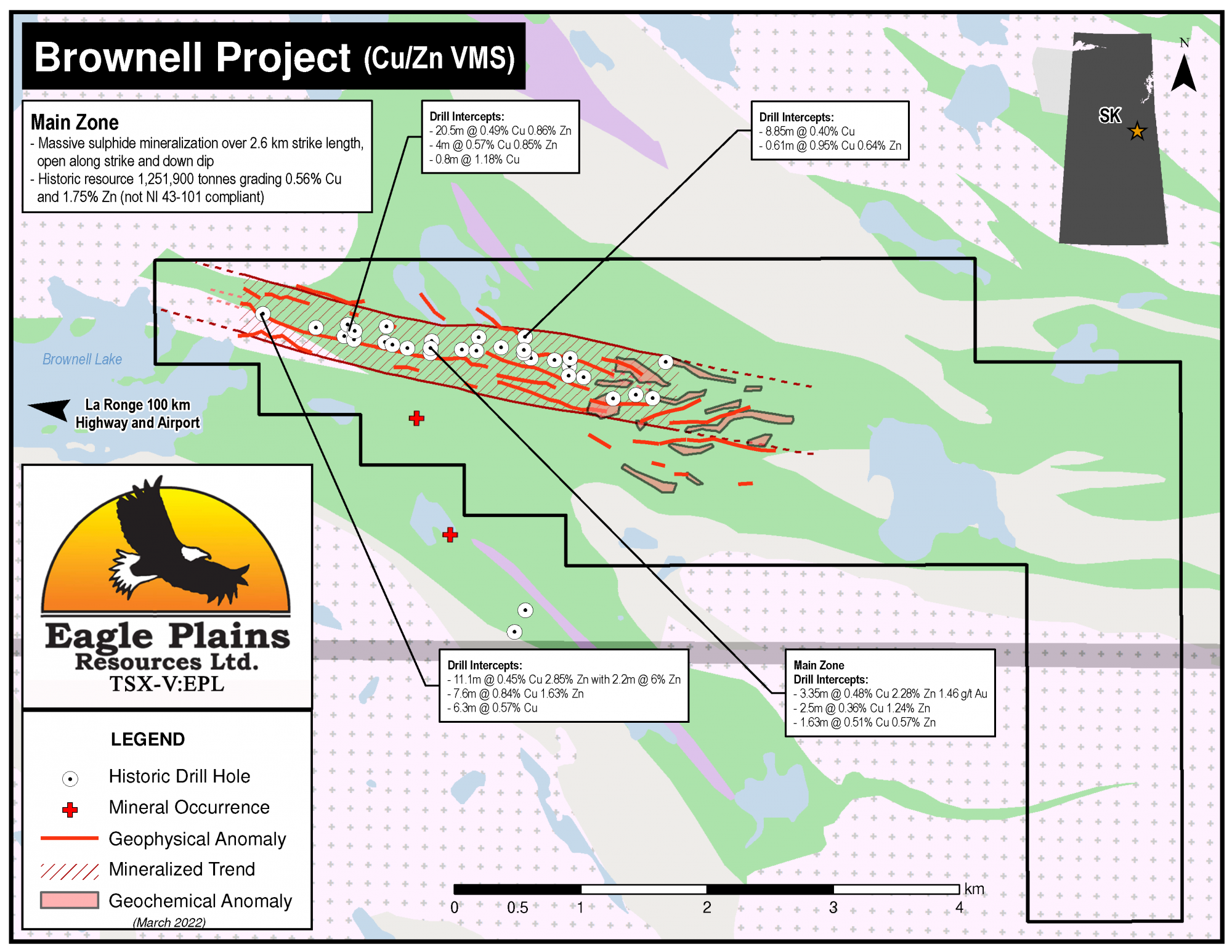
- Host to VMS mineralization with a historical resource of 1.25 million tonnes grading 0.56% Cu and 1.75% Zn*
- Significantly underexplored with encouraging early results
- Mineralization open in both directions along strike and to depth
- Encouraging exploration to date including multiple mineralized drill intercepts
- Multiple untested coincident geochemical/geophysical anomalies associated with mineralization
*Eagle Plains’ management considers these estimates to be historical in nature and cautions that a Qualified Person has not done sufficient work to classify the historical estimates as current mineral resources or mineral reserves in accordance with National Instrument 43-101. These estimates do not comply with current definitions prescribed by National Instrument 43-101 or the Canadian Institute of Mining, and are disclosed only as indications of the presence of mineralization and are considered to be a guide for additional work. The historical models and data sets used to prepare these historical estimates are not available to Eagle Plains, nor are any more recent resource estimates or drill information on the Property.
Summary
The 1863ha Brownell Lake Property is a highly prospective volcanogenic massive sulphide (“VMS”) polymetallic exploration project. Acquired in 2017, the property is located 100km east of La Ronge and 75km south of SSR Mining’s Seabee Gold Operation.
Project Highlights
- Host to VMS mineralization with a historical resource of 1.25 million tonnes grading 0.56% Cu and 1.75% Zn*
- Significantly underexplored with encouraging early results
- Mineralization open in both directions along strike and to depth
- Encouraging exploration to date including multiple mineralized drill intercepts
- Multiple untested coincident geochemical/geophysical anomalies associated with mineralization
*Eagle Plains’ management considers the mineral resource estimates to be historical in nature and cautions that a Qualified Person has not done sufficient work to classify the historical estimates as current mineral resources or mineral reserves in accordance with National Instrument 43-101. These estimates do not comply with current definitions prescribed by National Instrument 43-101 or the Canadian Institute of Mining, and are disclosed only as indications of the presence of mineralization and are considered to be a guide for additional work. The historical models and data sets used to prepare these historical estimates are not available to Eagle Plains, nor are any more recent resource estimates or drill information on the Property.
Geology
The geology on and surrounding the Brownell Property consists of arcuate belts of supracrustal and plutonic rocks at the southern end of the Glennie Domain. The property is at the northeast edge of the Brownell Lake Greenstone Belt at its contact with the Kvamsing Cataclastic Belt. The Brownell Lake pluton occurs at the southwestern edge of the property, it consists of diorite to quartz-diorite.
History
Government mapping programs began in 1913 with additional mapping, geochemical and geophysical surveys being carried out into modern times.
In 1958, base-metals were discovered when following up a geophysical anomaly at the Main Zone near the eastern end of Brownell Lake. Drilling during the 50’s, 60’s and 70’s delineated massive sulphide mineralization along an east-trending geophysical anomaly defining the Main Zone. In 1981, the available core was reinterpreted as VMS-style. Mapping, prospecting, geochemical and geophysical surveys verified mineralization at the Main Zone anomaly and located several other parallel geophysical anomalies.
In 1991, a soil geochemical survey tested geophysical anomalies with inconclusive results. Six drill holes on the Main Zone confirmed previous drill results. At the Lyn Zone, 1 km SE of the Main Zone, geophysical anomalies were identified. Follow up mapping, geochemical sampling and drilling did not locate any significant mineralization.
A historical resource (Non-43-101 compliant) had been calculated based on drill results, this resource was 1.25 million tonnes grading 0.56% Cu and 1.75% Zn.
Eagle Plains Exploration
In early 2018 all available geological data was compiled into a database. It was found that surficial geochemical data is limited and geochemical analysis of drill core to be sporadic along with variable levels of detail in the core logs.
Much of the past work has focused on the mineralized Main Zone targeting E-SE trending geophysical anomalies. Most drill holes intersect semi-massive or brecciated sulphide mineralization which appears open both down dip and along strike in both directions. Given the north-dipping orientation of mineralization and spacing/orientation of the drill holes, there appears to be multiple mineralized layers. The magnetic anomaly associated with mineralization is at least 6km long, whereas the ground-based VLF-EM survey and drill holes only cover 2.6km of this extent.
A field program consisted of four components was conducted in the summer of 2018, ground mag-vlf geophysics, soil sampling, mapping/prospecting and resampling of historic drill core.
Future Work
A modest ground-based program including mag-vlf geophysics, mapping/prospecting and soil sampling in the area of historical drilling is recommended in order to correlate/increase confidence in the historical data. The area to the east of this which was covered by the 2018 Eagle Plains program is ready to be drill tested, it is beleived that this area was not drilled historically because it was outside the tenure at that time
Eagle Plains - A Project Generator
Eagle Plains Resources is a project generator with several mineral exploration properties of merit that meet qualifying transaction requirements. We facilitate the listing process for capital pool companies and initial public offerings while providing technical expertise for exploration programs. Companies interested in co-operatively exploring any of our projects please contact: Chuck Downie at ccd@eagleplains.com or Mike Labach at mgl@eagleplains.com or call 1 866 Hunt Ore (486 8673).
The Brownell Lake project is currently unavailable for option.
Details
The 1863ha Brownell Lake Property is a highly prospective volcanogenic massive sulphide (“VMS”) polymetallic exploration project. The claims were acquired in 2017 as part of a larger area that includes the Olson Project. The property is located 100km east of La Ronge and 75km south of SSR Mining’s Seabee Gold Operation.
It is accessible by fixed wing aircraft from the village of Pelican Narrows located 47km SE which in turn is serviced by an airport, Hwy 135 - an all-weather road and a hydro power grid. Access for summer work crews by helicopter and overland in the winter is staged from Deschambault Lake located 18km SE.
The project is 100% owned by Eagle Plains with a 2% NSR held by Eagle Royalties containing a 1% buy-back clause.
Project Highlights
- Host to VMS mineralization with a historical resource of 1.25 million tonnes grading 0.56% Cu and 1.75% Zn*
- Significantly underexplored with encouraging early results
- Mineralization open in both directions along strike and to depth
- Encouraging exploration to date including multiple mineralized drill intercepts
- Multiple untested coincident geochemical/geophysical anomalies associated with mineralization
*Eagle Plains’ management considers the mineral resource estimates to be historical in nature and cautions that a Qualified Person has not done sufficient work to classify the historical estimates as current mineral resources or mineral reserves in accordance with National Instrument 43-101. These estimates do not comply with current definitions prescribed by National Instrument 43-101 or the Canadian Institute of Mining, and are disclosed only as indications of the presence of mineralization and are considered to be a guide for additional work. The historical models and data sets used to prepare these historical estimates are not available to Eagle Plains, nor are any more recent resource estimates or drill information on the Property.
Geology
The geology on and surrounding the Brownell Property consists of arcuate belts of supracrustal and plutonic rocks at the southern end of the Glennie Domain. The Glennie Domain consists of amphibolite-grade intercalated metavolcanic rocks and metasedimentary rocks with mafic to felsic plutonic rocks, it is interpreted as a Paleoproterozoic island arc. The Glennie Domain is bound to the east by the Tabbernor fault system, a regionally-extensive structure with mylonite overprinted by brittle faulting.
The Brownell Property is at the northeast edge of the Brownell Lake Greenstone Belt at its contact with the Kvamsing Cataclastic Belt along the Lake shear zone. The Kvamsing Cataclastic Belt consists of deformed amphibolite that probably has a mafic volcanic protolith. The Brownell Lake Greenstone Belt in this property consists of interlayered mafic metavolcanic rocks, metapelite, and lesser felsic metavolcanic rocks. The Lake shear zone is at the northeast end of the Brownell Property, its trace appears folded and follows Brownell Lake. The Brownell Lake pluton occurs at the southwestern edge of the property, it consists of diorite to quartz-diorite.
History
In the Brownell Lake area, reconnaissance geology in the form of government mapping programs began in 1913 with several additional mapping programs being carried out into modern times. Additional government datasets include lake sediment geochemistry and aeromagnetic surveys.
Mineral exploration on the property has focussed near the eastern end of Brownell Lake. Base-metal mineralization was discovered in 1958 by the Canadian Nickel Company (Inco’s exploration arm) when following up on an anomaly from an airborne magnetic and electromagnetic survey. Diamond drilling during the late 1950s and early 1960s delineating massive sulphide mineralization along an east-trending magnetic and electromagnetic anomaly known as the Main Zone. Other diamond drilling by Obaska Mines in 1971 also focussed on this Main Zone anomaly.
In 1981 Dunlop purchased the tenure and re-examined the 1971 core but they were unable to locate most of the core from the 1960s. The core was reinterpreted as volcanic instead of sedimentary and mineralization interpreted as VMS-style. Through the 1980s and early 1990s, Dunlop and partners conducted geologic mapping, prospecting, minor soil geochemical surveys, and magnetic/electromagnetic surveys. They verified mineralization on the east-trending geophysical anomaly within the Main Zone and located several other geophysical anomalies parallel to this mineralized anomaly.
Spectra Management purchased the tenure in 1991 and completed a soil geochemical survey to test previously-identified geophysical anomalies with inconclusive results. Spectra completed six diamond drill holes on the Main Zone and confirmed previous drill results.
The Lyn Zone is approximately 1 km southeast of the Main Zone. Geophysical anomalies were identified in this area; follow up geologic mapping, rock geochemical sampling, and diamond drilling did not locate any significant mineralization.
A historical resource (Non-43-101 compliant) had been calculated based on drill results, this resource was 1.25 million tonnes grading 0.56% Cu and 1.75% Zn.
Eagle Plains Exploration
Data Compilation
In Spring of 2018, the available historic data was digitized, referenced in GIS, and imported into a database.
Interpreted VLF-EM conductors were digitized from previous ground-based geophysical surveys over the “main zone” and airborne surveys over the entire property.
Surficial geochemical data are limited with few grab samples and none over the Main Zone which was geologically mapped but not sampled. Soil samples are from small grids around EM conductors.
The majority of drill hole data is from the 1950s through early 1970s with sporadic geochemical analyses and variable in the level of detail and lithologic descriptions of the core logs.
Interpretation
Most data are from the mineralized Main Zone in the northern part of the property. Historic exploration delineated and targeted east-southeast-trending EM and magnetic anomalies in this area.
Most drill holes intersect semi-massive or brecciated sulphide mineralization. Anomalous Cu and/or Zn intervals are generally 5-10 m and up to ~20 m wide. Mineralization appears to be semi-continuous through these zones, with multiple less than 1m wide intervals of semi-massive or brecciated pyrite, pyrrhotite, sphalerite, and chalcopyrite. Stringers and blebs of sulphide occur near the margins of the mineralized zone with elevated Cu/Zn grades. Cu and Zn grades appear inversely correlated.
Anomalous Cu, Zn, and Au in soil values are weakly correlated with the location of EM conductors and mineralized zones. These anomalous soil surveys are too small to assess their implications or value.
Grab samples from the southern part of the property have anomalous Cu and Ni values that appear to correspond to southeast-trending magnetic and EM anomalies. Mineralization was not identified in this area after geologic mapping and two diamond drill holes. However, this work was conducted in the 1960s and drill core was not assayed.
Mineralization in the Main Zone appears open both down dip and along strike in both directions. Drill holes from the same collar intersect mineralized layers that appear continuous down-dip. Drill holes that extend ~350m perpendicular to the strike of the mineralization intersect mineralized horizons. Given the proposed north-dipping orientation of mineralization and spacing/orientation of these drill holes, there appears to be multiple mineralized layers. The western extension of the mineralized Main Zone is undocumented; there are no comments on mineralization in the core logs nor assays from the westernmost drill holes. The magnetic anomaly associated with mineralization is at least 6km long, whereas the ground VLF-EM survey and drill holes only cover 2.6km of this extent. The VLF-EM anomaly and mineralization are likely to extend further along-strike with this magnetic anomaly.
Target Model
Exploration on the Brownell Property should focus on VMS mineralization, predominantly hosted in metavolcanic rocks. There is additional potential for structurally-hosted orogenic gold and intrusion-related gold in and around plutons.
VMS exploration should focus on metavolcanic rocks with corresponding EM and magnetic anomalies. Compositional layering and foliation dip moderately to steeply to the north-northeast, therefore geophysical anomalies trending east-southeast are the primary exploration target for these stratabound deposits.
The primary target for exploration on the Brownell property is the down-dip and along-strike extension of the mineralized Main Zone. The ESE-trending magnetic anomaly continues along strike to the east and west, beyond the extent of the ground VLF-EM survey. There is no apparent cut off of mineralization from diamond drill holes at the eastern or western extent of the Main Zone.
A SE-trending magnetic anomaly and EM conductor in southern Brownell property is another exploration target. Grab samples and two drill holes from this area did not find any mineralization, but that was from one survey in the 1960s with only partial coverage of the geophysical anomaly.
Deformation and possible remobilization of VMS deposits may complicate exploration. Mineral lineation plunges moderately northeast, stretched out ore zones may follow this structural trend.
2018 Exploration
The 2018 exploration program consisted of four components:
- ground Mag-VLF geophysics in order to extend historic VLF-EM conductors to the southeast
- soil sampling program completed along the 2018 Mag-VLF lines. Prospecting involved grid sampling
- mapping/prospecting program along the soil and Mag-VLF lines for the purpose of whole rock analysis and alteration mapping
- resampling of historic drill core gain a better understanding of the hydrothermal alteration signature of the Brownell Lake Cu-Zn zone
Future Work
A modest ground-based program including mag-vlf geophysics, mapping/prospecting and soil sampling in the area of historical drilling is recommended in order to correlate/increase confidence in the historical data. The area to the east of this which was covered by the 2018 Eagle Plains field program is ready to be drill tested, it is beleived that this area was not drilled historically because it was outside the tenure at that time.
Eagle Plains - A Project Generator
Eagle Plains Resources is a project generator with several mineral exploration properties of merit that meet qualifying transaction requirements. We facilitate the listing process for capital pool companies and initial public offerings while providing technical expertise for exploration programs. Companies interested in co-operatively exploring any of our projects please contact: Chuck Downie at ccd@eagleplains.com or Mike Labach at mgl@eagleplains.com or call 1 866 Hunt Ore (486 8673).
The Brownell Lake project is currently unavailable for option.
Updated April 30, 2024

Eagle Plains Secures Contractors for Fully Funded Drill Program at the Vulcan Project

Eagle Plains/Pacific Imperial Announce Geophysical Program at Brownell Lake Copper Project, Saskatchewan