Pine Channel Project
The 6358 ha Pine Channel Property is located 43 km west of Stoney Rapids, Sask. and is accessible by fixed wing aircraft or boat.
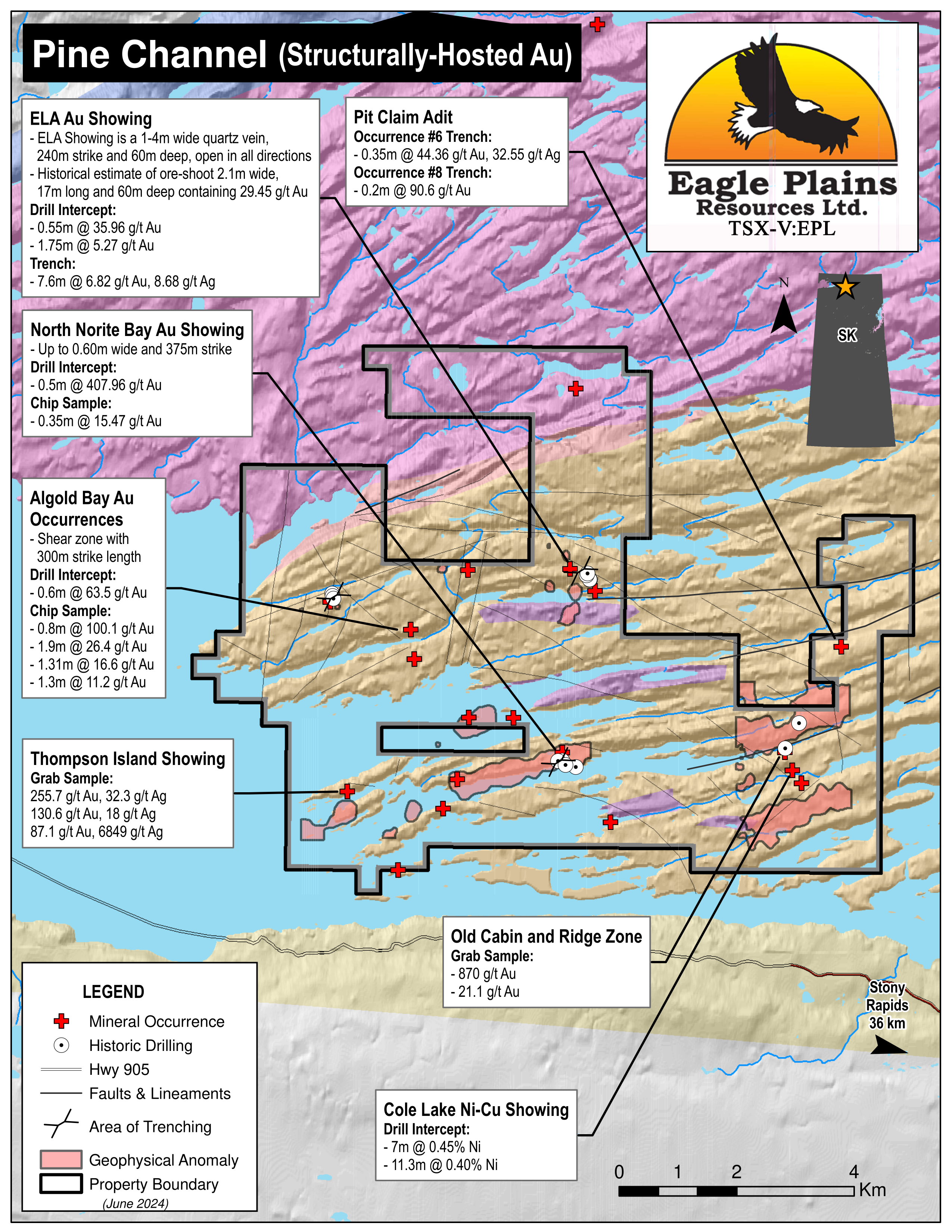
Highly prospective for fracture-hosted gold, the property contains 17 mineral occurrences and has not been explored since 1988. Reports compiled near and after exploration ceased provide a solid geological model for future programs. The project is bisected by a hydro power line.
-
- Saskatchewan
-
- Available for option: No
-
- Gold,
- Silver,
- Nickel,
- Copper,
- Uranium
Project Highlights
- Prior to acquisition it has not been explored since 1988
- Multiple encounters of bonanza-grade gold in drill intercepts
- Numerous mineralized gold occurrences
- Encouraging exploration to date with most drilling <100m
- Hydro powerline bisecting the property
Summary
The 6358 ha Pine Channel Property is located 43 km west of Stoney Rapids, Sask. and is accessible by fixed wing aircraft or boat. Highly prospective for fracture-hosted gold, the property contains 17 mineral occurrences and has not been explored since 1988. Reports compiled near and after exploration ceased provide a solid geological model for future programs. The project is bisected by a hydro power line.
Project Highlights
- Prior to acquisition it has not been explored since 1988
- Multiple encounters of bonanza-grade gold in drill intercepts
- Numerous mineralized gold occurrences
- Encouraging exploration to date with most drilling <100m
- Hydro powerline bisecting the property
Geology
The Pine Channel project lies within the Tantato Domain and the lithologies are predominantly supracrustal and appear to be derived from volcaniclastics manifest as felsic to mafelsic granulites and gneisses. These supracrustals were later intruded by granitoid bodies.
Numerous gold occurrences have been discovered within the property boundary which is located along the SW portion of the Tantato structure. This area is host to a structurally lower sequence of mylonitic garnet-quartzofeldspathic gneisses and mylonitic garnet-clinopyroxene mafic gneisses. The garnet-quartzo-feldspathic gneisses are strongly differentiated between discontinuous quartz lenses alternating with feldspar layers. The garnet-clinopyroxene gneisses have variously been referred to as norites, and meta-basites that are most likely derived from extrusive and intrusive igneous rocks. These mafic gneisses are host to concordant zones of pyrrhotite and pyrite mineralization and locally are associated with graphitic schists. The rocks have been subject to polyphase metamorphism with the dominant foliation trending to the northeast and rocks typically dipping between 40°-60° to the southeast.
Mineral Occurrences
There are 19 historical mineral occurrences on the Pine Channel Property, the majority of which are interpreted to host structurally-controlled mesothermal lode gold mineralization. Nickel and uranium are also present on the property and appear to be structurally controlled in polymetallic veins and intrusion-hosted magmatic. Notable results from some of the showings include:
| Zone | Results | Sample Type |
|---|---|---|
| ELA Au | 0.55m @ 39.96 g/t Au | Drill intercept |
| MEL-CEC | 0.6m@63.5 g/t Au | Drill intercept |
| Occurrence #6 & #8 | 0.35m @ 44.36 g/t Au and 32.55 g/t Ag | Trench |
| Cole Lake Ni-Cu | 7.0m @ 0.45% Ni | Drill Intercept |
| North Norite Bay | 0.5m @ 407.96 g/t Au | Drill Intercept |
| Occurrence #9 | 2.0m @ 4.3 g/t Au | Chip |
History
Reconnaissance geology and mapping programs by government began in the late 1950’s. Additional government datasets include 3 airborne geophysical surveys and GSC lake sediment geochemistry.
Industry exploration began in 1950 and a total of 41 work programs have been conducted to 1988. These include 126 drill holes over 15 drill programs, 17 geophysical surveys of various types and size, trenching, geologic mapping, prospecting, soil and rock sampling, biogeochemical and sediment sampling. The drilling mainly used small diameter (AX) core which is poorly suited to sampling high-grade, nuggety gold mineralization. As a result, the low gold grades obtained in drill core relative to the high grades observed at surface are likely not accurate. Additionally, most of the drilling has been relatively shallow (~<100 m) and the potential to test for further continuity at depth is considered to be excellent
Eagle Plains Exploration
A review of all available data was conducted in 2018 concluding that there are three styles of mineralization on the property of which the fracture-hosted gold mineralization is the focus of exploration activities.
Future Work
Previous operators had contrasting ideas about why and where mineralized fracture zones should be found. The latest thoughts are that mafic gneiss-graphitic schist contacts may represent significant exploration corridors. As a result, future exploration programs will consider:
- Prospecting along strike of strong geophysical conductors related to graphite schist-mafic gneiss contacts for N to NW trending mineralized fracture zones
- Targeting coincident Arsenic and geophysical anomalies for discovering new Au occurrences
Eagle Plains - A Project Generator
Eagle Plains Resources is a project generator with several mineral exploration properties of merit that meet qualifying transaction requirements. We facilitate the listing process for capital pool companies and initial public offerings while providing technical expertise for exploration programs. Companies interested in co-operatively exploring any of our projects please contact: Chuck Downie at ccd@eagleplains.com or Mike Labach at mgl@eagleplains.com or call 1 866 Hunt Ore (486 8673).
The Pine Channel project is currently unavailable for option.
Details
The 6358 ha Pine Channel Property is a highly prospective fracture-hosted gold project located 43 km west of Stoney Rapids, a community accessible by both Hwy 905 and air, located on Lake Athabasca in northern Saskatchewan. The Pine Cannel Property can be accessed year-round by fixed wing aircraft from Stony Rapids or by boat along the Fond du Lac/Lake Athabasca River system in the summer. The project is bisected by a hydro power line.
Two reports compiled near and after the cessation of exploration activities in 1988 reviewed the gold potential of the area and provided a solid geological model from which to focus exploration.
Acquired in early 2019, the project is 100% owned by Eagle Plains with a 2% NSR held by Eagle Royalties containing a 1% buy-back clause.
Project Highlights
- Prior to acquisition it has not been explored since 1988
- Multiple encounters of bonanza-grade gold in drill intercepts
- Numerous mineralized gold occurrences
- Encouraging exploration to date with most drilling <100m
- Hydro powerline bisecting the property
Geology
The Pine Channel project lies within the Tantato Domain composed of highly deformed mylonitic gneisses forming the eastern margin of the Archean Rae Craton. The lithologies within the domain are predominantly supracrustal and appear to be derived from volcaniclastics manifest as felsic to mafelsic granulites and gneisses. The supracrustals of the Tantato Domain were later intruded by granitoid bodies.
Numerous gold occurrences have been discovered within the property boundary which is located along the SW portion of the Tantato structure. This area is host to a structurally lower sequence of mylonitic garnet-quartzofeldspathic gneisses and mylonitic garnet-clinopyroxene mafic gneisses. The garnet-quartzo-feldspathic gneisses are strongly differentiated between discontinuous quartz lenses alternating with feldspar layers. The garnet-clinopyroxene gneisses have variously been referred to as norites, and meta-basites that are most likely derived from extrusive and intrusive igneous rocks. These mafic gneisses are host to concordant zones of pyrrhotite and pyrite mineralization and locally are associated with graphitic schists. The rocks have been subject to polyphase metamorphism with the dominant foliation trending to the northeast and rocks typically dipping between 40°-60° to the southeast.
Mineral Occurrences
There are 19 historical mineral occurrences on the Pine Channel Property, the majority of which are interpreted to host structurally-controlled mesothermal lode gold mineralization. Nickel and uranium are also present on the property and appear to be structurally controlled in polymetallic veins and intrusion-hosted magmatic.
Some of the more notable of these showings include:
ELA Au Showing
The ELA Au showing is a quartz vein mineralized with arsenopyrite, pyrite, and minor chalcopyrite disseminations. The vein varies between 1-4m wide, a strike length of 240m and 60m deep, open on both ends and to depth. Drilling assays reported from 0.31 g/t Au over 0.7 m to 35.96 g/t Au over 0.55 m. A size estimate of an ore shoot within the vein system was released in 1952 and recalculated again 1982 suggesting a high-grade shoot of 36.6 m long, 1.2 m wide and 60 m deep with a grade of 15.81 g/t Au. The 1982 estimate calculated it to be 17.0 m long and 2.1 m wide with an uncut grade of 29.45 g/t Au. Later work traced the vein for 240 m and in 1987, 12 NQ drill holes traced the mineralized vein to 38m deep, highlights from these programs include:
| Sample Type | Results | Description of Zone and Sampling |
|---|---|---|
| Drill Intercept | 0.55m @ 39.96 g/t Au |
ELA Au Showing, 1-4m wide, 240m strike |
| Drill Intercept | 0.52m @ 45.26 g/t Au | |
| Drill Intercept | 1.75m @ 5.27 g/t Au | |
| Trench | 7.6m @6.82 g/t Au, 8.68 g/t Ag | |
| Trench | 3.0m @ 24.52 g/t Au |
Algold Bay Zone Au Showings
The Algold Bay Zone covers several Au mineralized showings on the north shore of Lake Athabasca. Gold mineralization at Algold Bay was first reported in 1935 and subsequent work has included prospecting, trenching, geophysical surveys, and 5 short diamond drill holes, with the last recorded work in 1988 by Colchis Resources. The MEL-CEC showing is a NW striking, vertically-dipping shear zone exposed for approximately 300m strike length. The Algold Creek occurrence is a massive quartz-tourmaline vein 3.7m in width while the Occurrence 3 Au Showing is comprised of quartz stringers with arsenopyrite and visible gold. Exploration highlights from these showings include:
| Sample Type | Results | Description of Zone and Sampling |
|---|---|---|
| Drill Intercept | 0.6m @ 63.5 g/t Au | MEL-CEC |
| Chip Sample | 0.8m @ 100.1 g/t Au and 1.9m @ 26.4 g/t Au |
MEL-CEC |
| Grab Sample | 9 g/t Au | Algold Creek |
| Grab Sample | 5.7 g/t Au | Occurrence #3 |
PIT Claim Adit - Occurrences #6 and #8
These showings collectively known as the PIT Claim Adit are located 150m to 200m apart. Occurrence #6 Au consists of 5 veins. Veins 1-3 host hosting tourmaline, arsenopyrite and pyrite mineralization while veins 4 & 5 host to considerable arsenopyrite, minor pyrite and may or may not contain quartz. Located to the west, Occurrence #8 Au is a 60m long 0.03-0.3 m wide quartz vein hosted within garnet-quartz-feldspar paragneiss. The vein is mineralized with arsenopyrite and rare specks of native copper.
| Sample Type | Results | Description of Zone and Sampling |
|---|---|---|
| Trench | 0.35m @ 44.36 g/t Au and 32.55 g/t Ag | Occurrence #6 West |
| Trench | 0.2m @ 5.18 g/t Au and 0.45m @ 3.78 g/t Au | Occurrence #6 East Vein |
| Trench | 0.2m @ 90.6 g/t Au | Occurrence #8 |
| Trench | 0.3m @ 3.32 g/t Au and 0.71 g/t Ag | Occurrence #8 |
Cole Lake Ni-Cu Occurrence
The Cole Lake Occurrence is a nickeliferous pyrrhotite zone occurring within a 12.1m wide norite body. The norite body is underlain by paragneisses and has been traced for 183m on strike. Pyrrhotite is disseminated throughout the norite and also concentrated in a ~1.0 m wide gossanous fractured central portion of the norite. Four drill holes and chip sampling from trenches were conducted with the following highlights:
| Sample Type | Results | Description of Zone and Sampling |
|---|---|---|
| Drill intercept | 0.45% Ni over 7.0 m | Cole Lake Ni-Cu - drill hole #1 |
| Drill intercept | 0.40% Ni over 11.3 m | Cole Lake Ni-Cu - drill hole #2 |
| Drill intercept | 0.65% Ni over 4.6 m | Cole Lake Ni-Cu - drill hole #4 |
| Trench | 0.97% Ni and 0.13% Cu over 2.3 m | Cole Lake Ni-Cu |
North Norite Bay Au Showing
This showing is a quartz filled shear zone with veins up to 0.6 m wide and traced over a strike length of 375m in biotite-quartz-feldspar gneiss. The quartz veins and surrounding sheared host rocks contain up to 10% combined pyrite an arsenopyrite. Twelve AX drill holes and chip sampling were completed to test the mineralized shear zone, highlights include:
| Sample Type | Results | Description of Zone and Sampling |
|---|---|---|
| Drill intercept | 0.5m @ 407.96 g/t Au | Drill hole 11 – AX size |
| Drill intercept | 0.33m of 4.71 g/t Au | Drill hole 05 – AX size |
| Chip | 15.47 g/t Au over 0.35 m | Quartz Vein |
| Chip | 57.91 g/t Au over 0.2 m | Quartz Vein |
Occurrence #9 Showing (Main Vein, Rob Au Showing and AC Au Vein)
The Occurrence No. 9 Au Showing includes three gold-bearing quartz veins (Main Vein, Rob Au Showing and AC Au Vein) hosted within metamorphosed intrusive rocks. The Main Vein is a 200 m long, 0.1-2.5 m wide north-south striking vertical vein that crosscuts the quartz-pyrite-arsenopyrite AC and Rob Veins. Quartz vein-hosted mineralization consists of veinlets and lenses of arsenopyrite, pyrite, pyrrhotite, and minor chalcopyrite with gold generally associated with semi-massive arsenopyrite mineralization.
| Sample Type | Results | Description of Zone and Sampling |
|---|---|---|
| Drill intercept | 0.53 g/t Au over 0.5 m | Main Vein – AX size drill |
| Drill intercept | 0.37 g/t Au over 0.5 | AC Zone – AX size drill |
| Chip | 4.3 g/t Au over 2.0 m | Main Vein |
| Grab | 14.88 g/t Au and 13.64 g/t Ag | Main Vein |
History
In the Pine Channel area, reconnaissance geology in the form of government reviews and mapping programs began in the late 1950’s. Several additional reports on uranium deposits and gold occurrences were carried out being carried out into modern times. In the late 80’s geological mapping at the 250k scale had been completed over the area. Additional government datasets include 3 airborne geophysical surveys and GSC lake sediment geochemistry.
Industry exploration of the area began in 1950 and a total of 41 work programs have been conducted within the property. These include 20 drill holes, prospecting, trenching, mapping and geophysics by Goldfields Uranium Mines from 1950-1952. Between 1955 and 1988 the property has been investigated by a number of companies including but not limited to Cominco, Denison, SMDC, Colchis Resources, Minatco, Inexco, Varmac Uranium and Western Mines. These companies preformed 36 programs on the property including 106 holes over 11 drill programs, 17 geophysical surveys of various types and size, trenching, geologic mapping, prospecting, soil and rock sampling, biogeochemical and sediment sampling.
The last exploration program to be carried out on the property was in 1988 and the majority of the drilling to that point was completed using small diameter (AX) core. This small core is poorly suited to sampling the high grade, nuggety gold mineralization present in the Pine Channel area and that the historically low gold grades that drilling returned relative to gold grades observed at surface are likely not accurate. In addition to this, most of the drilling on the property has been relatively shallow (~<100 m) and the potential to test for further continuity at depth is considered to be excellent.
Eagle Plains Exploration
A review of all available data was conducted in 2018 concluding that there are three styles of mineralization on the property: vein hosted uranium, pyrrhotiferous Ni-Cu mineralization hosted within norite bodies, and fracture hosted gold mineralization. The fracture hosted gold mineralization is the most likely to be present in quantities of economic significances and is the focus of exploration activities.
In 2019 Eagle Plains completed a limited field program to evaluate and confirm the nature of mineralization previously documented at historical showings. During this program rock samples were collected from various known occurrences and returned values ranging from 7 ppb Au up to a maximum of 77.5 g/t (2.73 oz/T) Au.
Future Work
Previous operators had contrasting ideas about why and where mineralized fracture zones should be found. The latest thoughts are that the fractures appear to have a gross stratabound nature wherein numerous occurrences within a given area can found at the same structural level along the mineralized trend. It was also thought that while granulite terranes, such as the Tantato, are not generally favourable for gold mineralization, the rocks of the Tantato have been strongly retrogressed during the Hudsonian orogeny to amphibolite facies which must have been associated with significant fluid volumes that could also have mobilized gold. It was also suggested that the development of the north to northwest trending fracturing and formation of quartz veining was related to late regional north to northwest shortening. Competency contrast between mafic gneisses (norites) and the often associated graphitic schists could have induced slip in the graphitic schists producing wider tensional opening in the more competent mafic gneisses. These tensional openings are then flooded with hydrothermal fluids and potentially mineralized with gold. Therefore these mafic gneiss-graphitic schist contacts may represent significant exploration corridors.
These conclusions have a number of implications for exploration and targeting of fracture related gold mineralization in the Pine Channel Area:
- Prospecting along strike of strong geophysical conductors that may be related to graphite schist-mafic gneiss contacts would be an excellent way to prospect for the north to northwest trending mineralized fracture zones.
- Arsenopyrite is associated with all of the gold mineralization and therefore any surface geochemical sampling that can reliably delineate As anomalies such as biogeochemistry may be useful to focus further prospecting.
- Electromagnetic geophysical anomalies that are supported by surface As anomalies should be first priority targets for the discovery of new gold occurrences.
Eagle Plains - A Project Generator
Eagle Plains Resources is a project generator with several mineral exploration properties of merit that meet qualifying transaction requirements. We facilitate the listing process for capital pool companies and initial public offerings while providing technical expertise for exploration programs. Companies interested in co-operatively exploring any of our projects please contact: Chuck Downie at ccd@eagleplains.com or Mike Labach at mgl@eagleplains.com or call 1 866 Hunt Ore (486 8673).
The Pine Channel project is currently unavailable for option.
Updated June 20, 2024

Eagle Plains Acquires Strategic Disposition at Pine Channel Gold Project, Saskatchewan

Eagle Plains’ Partner Apogee Completes Airborne Geophysical, Lidar Surveys at Pine Channel Gold Project, Saskatchewan

Eagle Plains Partner Apogee Minerals Commences Airborne Geophysical Survey at Pine Channel Gold Project
Photos