Shasko Bay Project
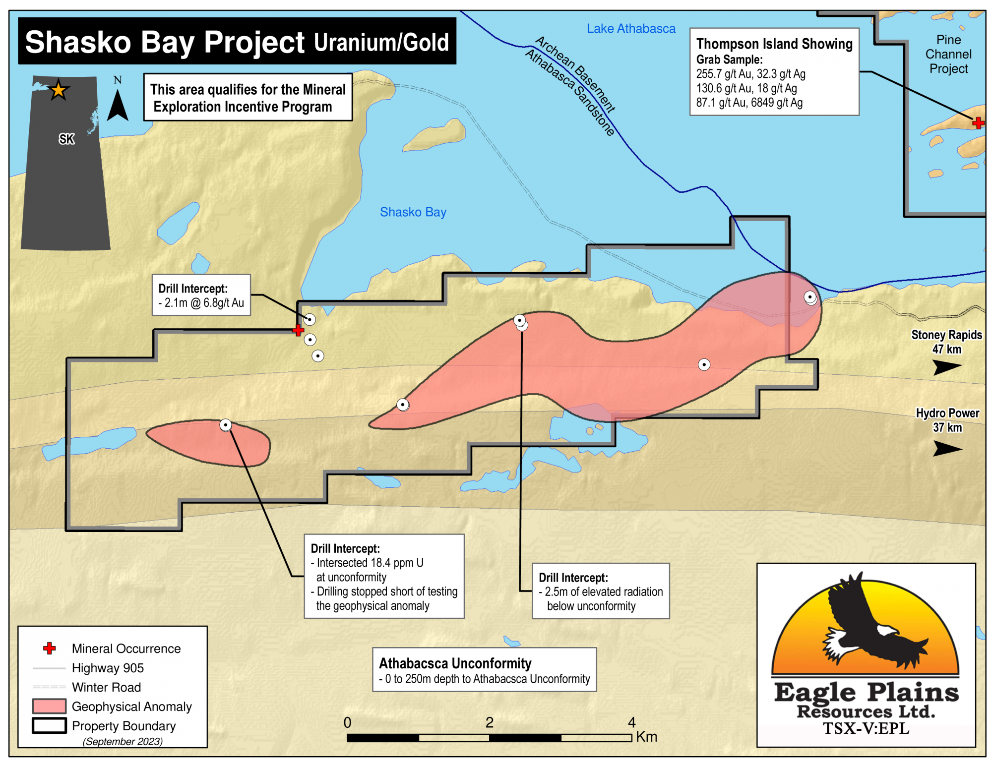
The 2571 ha Shasko Bay project is located along the SE shore of Lake Athabasca in northern Saskatchewan, 20 km SE of Fond-du-Lac, and adjacent to Eagle Plains’ Pine Channel Au project. The project was staked in 2023 for the potential of both gold and uranium mineralization.
The claims are accessible by boat, barge or float equipped aircraft from the village of Stony Rapids -- which has all season road access to southern infrastructure. The project is 100% owned by Eagle Plains with a 2% NSR held by Eagle Royalties containing a 1% buy-back clause. This area qualifies for the mineral exploration incentive program.
-
- Saskatchewan
-
- Available for option: No
-
- Uranium,
- Gold
Project Highlights
- Multiple untested geophysical anomalies associated with favourable geology
- Targets for multiple deposit models (Orogenic Au and Unconformity-U)
- Encouraging exploration to date including mineralized drill intercepts
- Mineralization underexplored and open in both directions along strike and to depth
- Excellent access with existing winter road to within 1km and central portions of the property accessible by boat or float plane
Summary
The 2571 ha Shasko Bay project is located along the SE shore of Lake Athabasca in northern Saskatchewan, 20 km SE of Fond-du-Lac, and adjacent to Eagle Plains’ Pine Channel Au project. The project was staked in 2023 for the potential of both gold and uranium mineralization.
The claims are accessible by boat, barge or float equipped aircraft from the village of Stony Rapids -- which has all season road access to southern infrastructure. The project is 100% owned by Eagle Plains with a 2% NSR held by Eagle Royalties containing a 1% buy-back clause. This area qualifies for the mineral exploration incentive program.
Project Highlights
- Multiple untested geophysical anomalies associated with favourable geology
- Targets for multiple deposit models (Orogenic Au and Unconformity-U)
- Encouraging exploration to date including mineralized drill intercepts
- Mineralization underexplored and open in both directions along strike and to depth
- Excellent access with existing winter road to within 1km and central portions of the property accessible by boat or float plane
Geology
The project area is underlain by shaley sandstone, shale and conglomerate of the Athabasca Group, with the NE tenure limit straddling the unconformity between the Athabasca Formation and underlying basement Archean high grade gneissic rocks belonging to the Tantato Domain. Depth to the Athabasca unconformity varies from 0-250m. Gold targets include perched paleo-placer horizons in the Athabasca Group and shear- and vein- lode gold structures in the underlying basement rocks. Uranium mineralization has discovery potential at both the flat lying Athabasca basin unconformity, and within feeder shear zones in the basement rocks, some of which have drill-proven graphite and sulphide bearing horizons.
History
Between the late 1960’s to the early 2000’s the region was explored for uranium and gold by various companies. The Fond Du Lac Uranium deposit is the most significant discovery in the region to date and is located 24km to the NWW.
Work in the area consisted of seismic reflection studies, multiple types of airborne and ground-based geophysical surveys, geochemical surveys, prospecting, mapping, trenching and 4 separate drill programs which intersected multi gram-per-tonne gold assays (up to 6.8 g/t Au over 2.1m) from quartz stringers in the Athabasca sediments. The underlying basement metasedimentary rocks, starting at 226m depth, also recoded mineralization in the form of disseminated pyrrhotite, pyrite, chalcopyrite and rare sphalerite, galena and molybdenite. In the 1980’s geophysics defined an 800m long conductor averaging 175m depth coincident with anomalous gold targets. The last drill program intersected anomalous uranium in Athabasca sandstone (up to 18.4 ppm) concluding with recommendations to drill test several additional targets.
Eagle Plains Exploration
In 2023 Eagle Plains Resources compiled the available data for the Shasko Bay property area.
Future Work
Several generations of geophysical and geochemical surveys at Shasko Bay have identified a plethora of promising gold and uranium targets with very few of these having been drill tested and a number of these contain gold and/or uranium with associated pathfinder elements.
Future work is to include comprehensive data compilation aided by ground-truthing of historical drill pads and geophysical cut-lines. A ground-gravity survey is recommended to assist in the definition of alteration haloes, along with updated geophysical modelling to integrate historical magnetic, EM and future gravity survey geophysical results. Future drill targets are to be derived from the results of this compilation and targeting exercise.
Eagle Plains - A Project Generator
Eagle Plains Resources is a project generator with several mineral exploration properties of merit that meet qualifying transaction requirements. We facilitate the listing process for capital pool companies and initial public offerings while providing technical expertise for exploration programs. Companies interested in co-operatively exploring any of our projects please contact: Chuck Downie at ccd@eagleplains.com or Mike Labach at mgl@eagleplains.com or call 1 866 Hunt Ore (486 8673).
The Shasko Bay Project is currently not available for option.
Details
The 2571 ha Shasko Bay project is located along the southeast shore of Lake Athabasca in northern Saskatchewan, 20 km southeast of Fond-du-Lac, and adjacent to Eagle Plains’ Pine Channel Au project.
Eagle Plains Resources Ltd. (EPL) staked the project in early 2023 in recognition of both the gold potential (with basement-hosted auriferous quartz veins and associated shears that strike onto the property from the Pine Channel Project); and for the unconformity uranium potential that is so well known in the district, in close proximity to basal contacts of the Athabasca Formation.
The claims are accessible by boat, barge or float equipped aircraft from the village of Stony Rapids which has all season road access to southern infrastructure. The project is 100% owned by Eagle Plains with a 2% NSR held by Eagle Royalties containing a 1% buy-back clause. This area qualifies for the mineral exploration incentive program.
Project Highlights
- Multiple untested geophysical anomalies associated with favourable geology
- Targets for multiple deposit models (Orogenic Au and Unconformity-U)
- Encouraging exploration to date including mineralized drill intercepts
- Mineralization underexplored and open in both directions along strike and to depth
- Excellent access with existing winter road to within 1km and central portions of the property accessible by boat or float plane
Geology
The property is underlain by Paleoproterozoic sedimentary rocks of the Athabasca Group and lies on the northern margin of the Athabasca Basin. Rocks of the Athabasca Group are interpreted to overlie basement rocks belonging to the Beaverlodge and Tantato structural domains. A major fault, the Grease River shear zone separates these tectonic domains and is interpreted to extend underneath the Athabasca Basin close to the northern boundary of the property. Athabasca Group rocks underlying the property have been mapped as quartz arenites of the Manitou Falls Formation.
The geology of the Shasko Bay property consists of Paleoproterozoic rocks of the Athabasca Group and Quaternary to recent unconsolidated sediments. Outcrop exposures are common and, based on the outcrops mapped, consist entirely of sandstone. In general, outcrops occur on north facing portions of roughly east to west trending linear topographic ridges. Towards the west the overburden appears to thicken and outcrops are less common. Sandstone beds are typically flat to very gently dipping (<5 degrees) and, on average, the regional dip appears to be to the south and it’s estimated that approximately 75‐100 metres of this stratigraphic section is exposed on the property.
Sandstones are typically quartz‐rich, variably hematite‐rich, moderately to well sorted and medium‐ to coarse‐grained. On fresh surfaces sandstone samples typically have pale beige, pink or purple colouration. Weathered samples are typically a brownish orange. Minor red siltstone or mudstone flat pebble clasts are present in some outcrops and are found as thin layers in the basal portions of sandstone beds. Beds are typically 50cm or less in thickness and vary from laterally continuous over about 20‐30m to lensoid over distances of a few metres. Trough cross‐stratification is the most common sedimentary structure. Wave ripple lamination was noted on some bed tops but this was not a common feature. Red siltstone units are found rarely and occur as recessive weathering, thin (less than 2cm) beds between sandstone units. A few paleocurrent measurements were taken from trough cross‐ stratified sandstones and these indicate a westward transport direction.
History
The region was explored for uranium and gold in the late 1960’s to early 1980’s by various companies. The most significant discovery in the region being the Fond Du Lac Uranium deposit, a shallow sandstone-hosted deposit and associated radioactive boulder trains located approximately 24km NWW of the property.
Exploration in 1963-65 focussed on the gold potential at or near the unconformity. Seismic reflection studies and airborne magnetic surveys were used to detect stratigraphic traps for paleo-placer gold and basement associated structures for lode gold targets. Drilling returned multi gram/tonne gold assays from quartz stringers in the Athabasca sediments. The underlying basement metasedimentary rocks, starting at 226m depth, also recorded mineralization in the form of disseminated pyrrhotite, pyrite, chalcopyrite and rare sphalerite, galena and molybdenite. Basement assays reported up to 0.6 g/t Au, 4.0 g/t Ag, and 0.06% Cu.
In the late 1960’s, Famok Ltd explored on and off the current project area for uranium by completing airborne radiometric and ground based seismic surveys followed by diamond drilling to basement, no significant uranium mineralization was encountered.
From 1977 – 1982 Eldorado Nuclear Ltd. completed a several programs including VLF, magnetic and radiometric geophysical surveys, hydro- and soil-geochemical surveys, geological mapping, trenching and diamond drilling of 4 holes to test 2 of 3 conductors defined by geophysics. The conductors were explained by combination of graphitic and sulphidic horizons and no exceptional radiometric intervals were encountered. Hole assays in basement did return some anomalous pathfinder elements including uranium to 12 ppm, arsenic to 1900 ppm, copper to 580 ppm, nickel to 180 ppm and boron to 10000 ppm.
In the mid to late 1980’s, Asitka Resources, followed by Athabasca Gold Resources continued gold exploration in the greater property area. Modern ground pulse EM and magnetic surveys defined an 800m long by 175m deep conductor overlapping the previous gold anomaly targets. Four closely spaced holes were drilled returning no significant gold assays. Despite the outcome, recommendations were to still follow up up on the many additional geophysical targets over the greater property area.
Between 2005 to 2008, RPT Uranium completed airborne MEGATEM survey over the greater property area and a 2007 VTEM plus magnetic survey followed by geological mapping, prospecting and boulder sampling. A 4 hole drill program was carried out targeting EM conductors spatially related to surface geochemical anomalies. Drilling encountered up to 18.4 ppm U in Athabasca sandstone with elevated Ni, Pb, As, Th, La, Co, B; and potential illite alternation near the basement unconformity concluding that the property is well endowed with geophysical targets with some supporting geochemistry, and that existing drill coverage is insufficient with recommendations to drill test several additional targets.
Eagle Plains Exploration
In 2023 Eagle Plains Resources compiled the available data for the Shasko Bay property area
Future Work
The Shasko Bay project has benefitted from several generations of geophysical and geochemical surveys that have identified a plethora of promising gold and uranium targets. Only a small percentage of these prospective targets have been drill tested, with a number of remaining untested targets containing gold and/or uranium with associated pathfinder elements.
Future work will include a comprehensive data compilation, to be aided by infield ground-truthing of historical drill pads and geophysical cut-lines. This may be followed by a ground-gravity survey to assist in the definition of alteration haloes, along with updated geophysical modelling to integrate historical magnetic, EM and future gravity survey geophysical results. Near future drill targets will be defined and drilled based on the results of this compilation and targeting exercise.
Eagle Plains - A Project Generator
Eagle Plains Resources is a project generator with several mineral exploration properties of merit that meet qualifying transaction requirements. We facilitate the listing process for capital pool companies and initial public offerings while providing technical expertise for exploration programs. Companies interested in co-operatively exploring any of our projects please contact: Chuck Downie at ccd@eagleplains.com or Mike Labach at mgl@eagleplains.com or call 1 866 Hunt Ore (486 8673).
The Shasko Bay Project is currently not available for option.
Updated April 30, 2023


Eagle Plains Increases Uranium Project Portfolio