Coyote Creek Project
The 436 ha Coyote Creek Property is located 50 km NE of Cranbrook, BC. The claims were acquired to cover a package of black shales and carbonates associated with highly-elevated base- and precious-metal geochemistry and a number of gypsum occurrences which are the focus of current work.
-
- British Columbia
-
- Available for option: Yes
-
- Gypsum
Project Highlights
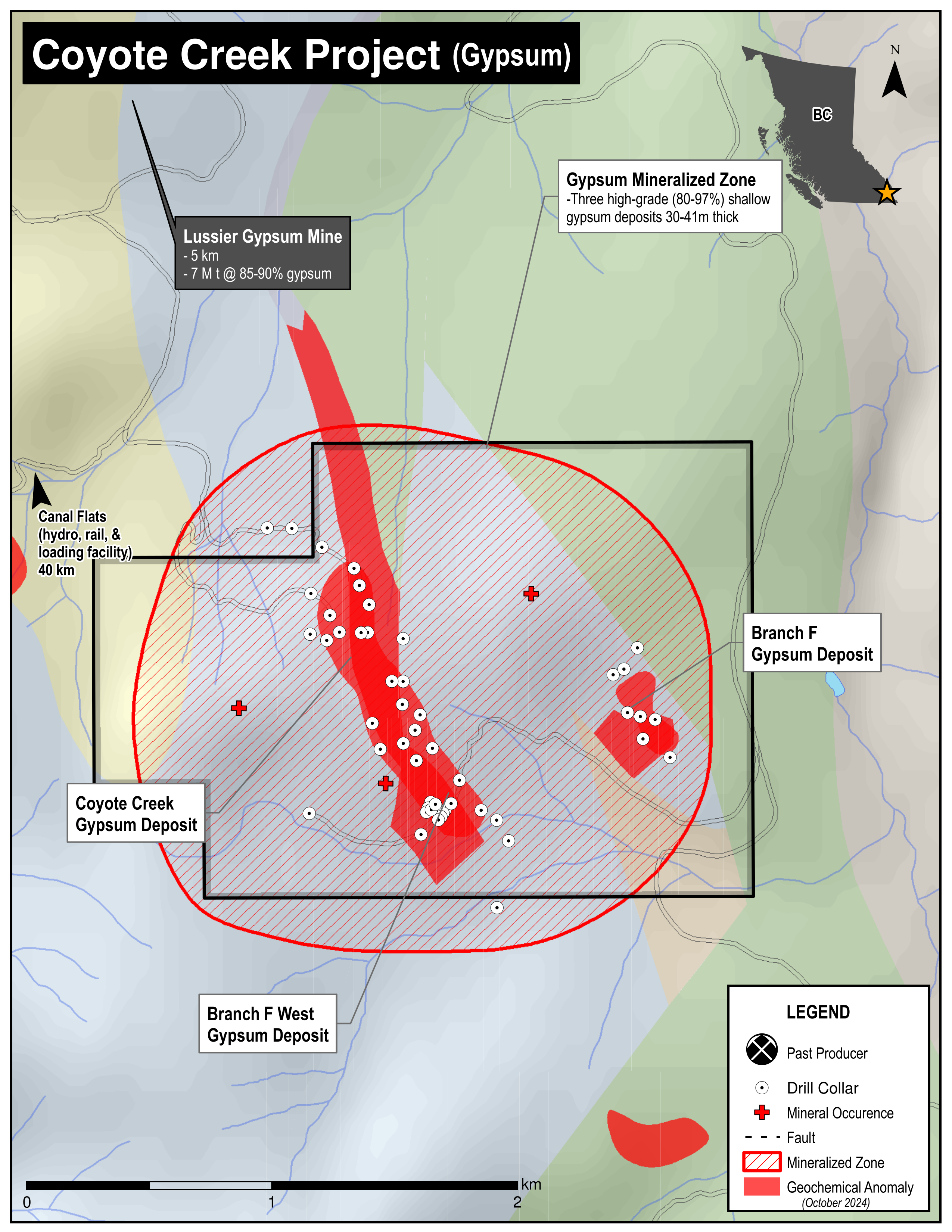
- Three known high-grade (80-97%), shallow gypsum deposits between 30-41 m thick identified through drilling
- Excellent infrastructure – all-weather road access, nearby rail, highway, hydroelectric
- Adjacent to past and current gypsum producers
- Widespread base-metal geochemical anomalies
- Base-metal potential significantly underexplored with encouraging early results
Summary
The 436 ha Coyote Creek Property is located 50 km NE of Cranbrook, BC. The claims were acquired to cover a package of black shales and carbonates associated with highly-elevated base- and precious-metal geochemistry and a number of gypsum occurrences which are the focus of current work.
Project Highlights
- Three known high-grade (80-97%), shallow gypsum deposits between 30-41 m thick identified through drilling
- Excellent infrastructure – all-weather road access, nearby rail, highway, hydroelectric
- Adjacent to past and current gypsum producers
- Widespread base-metal geochemical anomalies
- Base-metal potential significantly underexplored with encouraging early results
Geology
The Coyote Creek property is underlain by shallow and deeper water carbonate and fine grained clastic rocks. Fine-grained clastic units appear to underlie the bulk of the anomalous base-metal geochemistry. These units have minor surficial exposure and the majority of outcrops at lower elevations are in roadcuts.
The property geology can be viewed as a sequence of sedimentary rocks which has been folded into a broad and open syncline. The ridges that bisect the property are capped by the youngest rocks, resistant carbonates. The upper carbonates are encircled by successively older rocks that outcrop at lower elevations. The oldest rocks also appear mainly to be carbonates.
History
The Coyote Creek property area is distinguished by high zinc values with associated nickel, molybdenum and vanadium over the entire property area as identified by an RGS survey in 1991. Previous operators including Teck and Cominco focussed on soil and stream-sediment geochemical surveys. Although follow-up work was recommended, including geophysical surveys and trenching, no programs were carried out and the claims were allowed to lapse.
Eagle Plains Exploration
In 1999 Eagle Plains secured the entire area of interest outlined by the RGS survey and carried out property-scale geologic mapping and soil geochemical sampling. Encouraging results were followed-up with trenching and diamond drilling and although no significant base-metal mineralization was encountered by drilling, the highly-anomalous shale horizon was shown to be widespread both near surface and at depth.
In 2005, diamond-drilling successfully identified 3 gypsum deposits within the property. The ore zone is between 30 - 41 m thick with grades from 80 – 97% gypsum. The deposits are partially exposed or shallow buried.
Future Work
Base-metal exploration is to include geological mapping while using structural and lithological data as a guide for future diamond-drilling.
The areas of known gypsum should be further drill tested to measure size and grade of the gypsum resource and to determine the best location for a bulk sample.
Eagle Plains - A Project Generator
Eagle Plains Resources is a project generator with several mineral exploration properties of merit that meet qualifying transaction requirements. We facilitate the listing process for capital pool companies and initial public offerings while providing technical expertise for exploration programs. Companies interested in co-operatively exploring any of our projects please contact: Chuck Downie at ccd@eagleplains.com or Mike Labach at mgl@eagleplains.com or call 1 866 Hunt Ore (486 8673).
Coyote Creek is currently not available for option.
Updated October 4, 2024
Details
The Coyote Creek Property is located in the Lussier River/Coyote Creek area, 50 km NE of Cranbrook, BC. The 436 ha property is owned 100% by Eagle Plains and carries The project is 100% owned by Eagle Plains with a $1.50/tonne roylaty held by Eagle Royalties containing a 50% buy-back clause for $1M.
The Coyote Creek Claims were acquired by Eagle Plains to cover a package of black shales and carbonates associated with highly-elevated base- and precious-metal geochemistry. The claims also cover a number of gypsum occurrences which are the focus of current work.
Project Highlights
- Three known high-grade (80-97%), shallow gypsum deposits between 30-41 m thick identified through drilling
- Excellent infrastructure – all-weather road access, nearby rail, highway, hydroelectric
- Adjacent to past and current gypsum producers
- Widespread base-metal geochemical anomalies
- Base-metal potential significantly underexplored with encouraging early results
Geology
The Coyote Creek property is underlain by shallow and deeper water carbonate and fine-grained clastic rocks with probable Devonian and Mississippian ages. Fine-grained clastic units have minor surficial exposure, which appear to underlie the bulk of the areas of anomalous base-metal geochemistry which was the focus of the earlier base-metal exploration. There is a thick mantle of glacial till and glaciofluvial material in many places below 1600 metres, and glaciolacustrine deposits blanket many of the lowest lying areas. At higher elevations, colluvium is thick, in part because the resistant Mississippian carbonates have shed a blanket of talus and scree which covers the underlying and relatively recessive fine-grained clastic rocks. Many of the outcrops at lower elevations are in road cuts, although rare outcrops can be found on the steeper lower slopes and in stream banks.
At the most general level, the property geology can be viewed as a sequence of sedimentary rocks which has been folded into a broad and open syncline. The northerly-trending ridges between Coyote Creek and the Lussier River that bisect the property are capped by the youngest rocks, resistant carbonates of probable Mississippian age assigned to the Banff Formation. The upper carbonates are encircled by successively older rocks that in general outcrop at lower elevations. The oldest rocks, the Ordovician-Silurian Beaverfoot-Brisco Formation, also appear mainly to be carbonates.
History
The Coyote Creek Property is distinguished by high zinc values with associated nickel, molybdenum and vanadium over the entire property area, reflected in soil, silt and lithogeochemical samples. Interest in the area dated back to 1991 when results of a BCGS regional geochemical sampling (RGS) program indicated highly-anomalous zinc values for the ridge dividing Lussier River and Coyote Creek. All drainages for this area showed anomalous zinc values, ranging from 380 ppm to a high of 5500 ppm Zn.
Immediately following the RGS release, Teck Corporation, Cominco Exploration, and an individual prospector commenced staking activities. Because of the direct competition, each group managed to secure only small, irregular blocks of claims in the area. Work programs were subsequently carried out by each party, focusing on soil and stream-sediment geochemical surveys. Following a cursory exploration program, Teck geologists recommended follow-up work including geophysical surveys and trenching. Cominco also received favorable results, and reported that “more follow-up work is warranted”. Despite these recommendations, no further work was completed by either party, owing primarily to the compromised land position held by each. Over the next five years, all claims in the area were allowed to lapse.
Eagle Plains Exploration
In June 1999, Eagle Plains secured the entire area of interest outlined by the RGS study. During that summer, Eagle Plains carried out property-scale geologic mapping and a soil geochemical sampling program. Results from this program were very encouraging and follow-up work including trenching and diamond drilling was recommended.
In 2000, detailed trench sampling and diamond drilling were carried out. No significant base-metal mineralization was encountered by drilling. However, the highly-anomalous shale horizon was shown to be widespread both at or near surface and at depth in the drill holes. Further work was recommended for the property.
In 2005, the exploration focus shifted to defining the gypsum resource on the property. Three drill programs, totaling 46 diamond-drill holes, and partially funded by option partners, successfully identified 3 gypsum deposits within the property. The ore zone is between 30 - 41 m in thickness with grades from 80 – 97% gypsum. The deposits are partially exposed or shallow buried, two of the deposits have favorable access and topography to facilitate bulk sampling.
Future Work
Base-metal exploration should include geological mapping within and peripheral to the drill areas while exploiting structural and lithological data as a guide for future diamond-drilling programs.
The areas of known gypsum should be further drill tested to measure both size and grade of the gypsum resource and to determine the best location for a bulk sample.
Eagle Plains - A Project Generator
Eagle Plains Resources is a project generator with several mineral exploration properties of merit that meet qualifying transaction requirements. We facilitate the listing process for capital pool companies and initial public offerings while providing technical expertise for exploration programs. Companies interested in co-operatively exploring any of our projects please contact: Chuck Downie at ccd@eagleplains.com or Mike Labach at mgl@eagleplains.com or call 1 866 Hunt Ore (486 8673).
Coyote Creek is currently under option.
Updated October 4, 2024
Photos