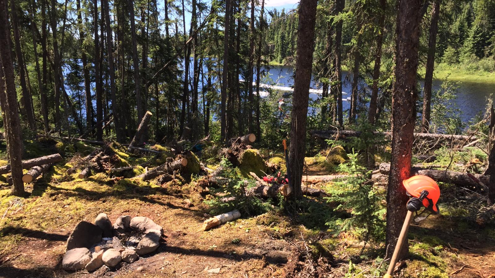
Dufferin West Project
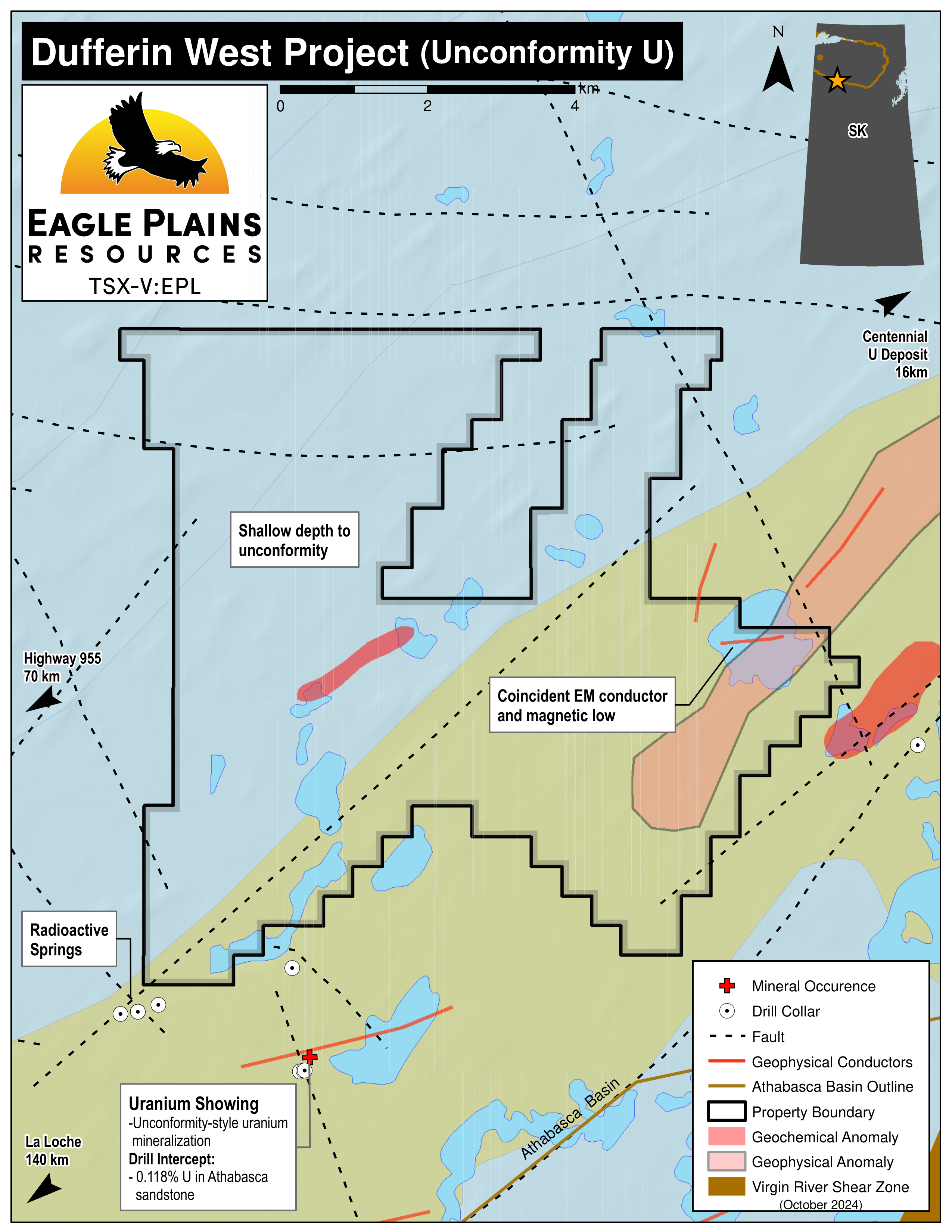
The 5465ha Dufferin West Property is located in NW Saskatchewan along the southern margin of the Athabasca Basin and is accessible by float-equipped aircraft from La Loche, Sask. 145km SW.
Acquired in 2023, the claims are 100% Eagle Plains with no underlying royalties and are highly prospective for unconformity uranium deposits, relatively underexplored and have not been drill tested.
-
- Saskatchewan
-
- Available for option: No
-
- Uranium
Project Highlights
- Excellent geology favourable for uranium deposits
- Significantly underexplored with encouraging early results
- Proven Uranium District
- Centennial U deposit is situated along-strike 20km to the ENE
- Prospective for unconformity- and basement-hosted uranium mineralization in proximity to NE-SW trending faults
Summary
The 5465ha Dufferin West Property is located in NW Saskatchewan along the southern margin of the Athabasca Basin and is accessible by float-equipped aircraft from La Loche, Sask. 145km SW. Acquired in 2023, the claims are 100% Eagle Plains with no underlying royalties and are highly prospective for unconformity uranium deposits, relatively underexplored and have not been drill tested.
Project Highlights
- Excellent geology favourable for uranium deposits
- Significantly underexplored with encouraging early results
- Proven Uranium District
- Centennial U deposit is situated along-strike 20km to the ENE
- Prospective for unconformity- and basement-hosted uranium mineralization in proximity to NE-SW trending faults
Geology
The geology of NW Sask. comprises NE trending belts of metamorphosed Archean-Proterozoic supracrustal and plutonic rocks of the Rae-Hearne craton overlain by siliciclastic rocks of the Proterozoic Athabasca basin. The suture zone of the Rae and Hearne provinces is a major structural corridor known as the Virgin River Shear Zone (VRSZ) south of the Athabasca Basin.
The major unconformity between metamorphic and granitic basement rocks and the overlying Athabasca Basin hosts the highest-grade uranium deposits in the world with most discoveries concentrated along the unconformity edge where cover is the thinnest. Dufferin West is located ~1.5km in from the southern margin of the basin overlying ~200m of the conglomeratic Manitou Falls Formation underlain by granitoid gneisses and high-grade metasedimentary rocks. The NE-SW trending trace of the VRSZ occurs 4km SE of the property.
History
Exploration programs have been conducted in the region from 1969 to recent, largely focused within the VRSZ and associated NE-SW trending faults. Geochemical and geophysical surveys are regional in scope and physical information. Lake sediment sampling located a geochemical anomaly along the western boundary while geophysics identified a NE=SW trending conductive zone in the NE corner of the property that overlaps a previously identified conductor of interest.
Eagle Plains Exploration
In late 2023, the available historic data was digitized and imported into a database. It is interpreted that a later phase of hydrothermal alteration and uranium remobilization occurred in this region after the primary phase of uranium mineralization ~1590 Ma suggesting a wider exploration approach to be taken.
Future Work
Recommendations for future work are to conduct a tier II data compilation followed by field programs including property scale airborne geophysics and targeted ground geophysical and geochemical surveys along NE-SW trending structures and conductors.
Eagle Plains - A Project Generator
Eagle Plains Resources is a project generator with several mineral exploration properties of merit that meet qualifying transaction requirements. We facilitate the listing process for capital pool companies and initial public offerings while providing technical expertise for exploration programs. Companies interested in co-operatively exploring any of our projects please contact: Chuck Downie at ccd@eagleplains.com or Mike Labach at mgl@eagleplains.com or call 1 866 Hunt Ore (486 8673).
The Dufferin West Project is currently not available for option
Details
The 5465ha Dufferin West Property is located in northwest Saskatchewan along the southern margin of the Athabasca Basin, 145km northeast of La Loche, Sask. and is highly prospective for unconformity uranium deposits. The claims are relatively underexplored and have not been drill tested.
The property is accessible by float-equipped wing aircraft from La Ronge, Sk. or Fort McMurray Ab.
The claims were acquired in 2023 are 100% owned by Eagle Plains with no underlying royalties or encumbrances.
Project Highlights
- Excellent geology favourable for uranium deposits
- Significantly underexplored with encouraging early results
- Proven Uranium District
- Centennial U deposit is situated along-strike 20km to the ENE
- Prospective for unconformity- and basement-hosted uranium mineralization in proximity to NE-SW trending faults
Geology
The geology of northwestern Saskatchewan comprises northeast trending belts of metamorphosed Archean-Proterozoic supracrustal and plutonic rocks of the Rae-Hearne craton overlain by siliciclastic rocks of the Proterozoic Athabasca basin. Archean-Proterozoic basement rocks are strongly deformed and metamorphosed from orogenic episodes 1.9 Ga and 1.8 Ga and capped by weathered regolith formed during surficial exposure prior to Athabasca Basin formation. Sedimentation of Athabasca fluvial sandstones and conglomerates occurred from ~1750-1540 Ma, creating the <2km thick sedimentary basin preserved today.
High-grade metamorphic and granitoid rocks of the Rae and Hearne provinces were accreted together during an orogeny ~1.9 Ga and sutured along a structural corridor called the Snowbird Tectonic Zone, south of the Athabasca basin, this zone is expressed by the Virgin River Shear Zone (VRSZ). The VRSZ is a major structural and tectonic feature comprising mylonitic and cataclastic rocks dividing the Rae province on the west from the Hearne province to the east. As a major tectonic feature, this zone has also hosted post-Athabasca brittle fault reactivations and brittle faulting along lithologic contacts and fabrics.
The major unconformity between metamorphic and granitic basement rocks and the overlying Athabasca Basin hosts the highest-grade uranium deposits in the world. The currently accepted model of uranium formation along the Athabasca unconformity is the reduction of oxidized uraniferous hydrothermal fluids flowing along reactivated basement faults. Reducing conditions are often attributed to graphitic rocks and shear zones where uranium mineralization is most commonly found. Most discoveries in the basin are concentrated along the unconformity edge where the sedimentary cover is the thinnest, but the discovery and tracing of faults below the basin cover is driving exploration further into the basin. In the Dufferin West area, unconformity uranium mineralization is found near faults parallel to and within the VRSZ.
The Dufferin West property is located along the southern edge of the Athabasca Basin, ~1.5km from the unconformity edge. This property overlies ~200m of the conglomeratic Manitou Falls Formation underlain by granitoid gneisses and high-grade metasedimentary rocks of the Taltson domain. The NE-SW trending trace of the VRSZ below the sedimentary cover occurs approximately 4km SE of the Dufferin West property.
Mineralization
There are no documented mineral occurrences within the Dufferin West tenure although several monometallic and polymetallic unconformity uranium occurrences are found along the Dufferin Lake fault and other NE-SW trending faults that transect the Dufferin West property. Sandstone- and basement-hosted uranium mineralization is predominantly found along these brittle post-Athabasca faults.
The most significant mineral occurrence in the region is the Centennial Zone which hosts sandstone- and basement-hosted unconformity uranium mineralization extending ~600m along a NNE trend where diamond drilling has intersected grades up to 25.6% U3O8 over 0.5m and 8.78% U3O8 over 33.9m. A relatively high concentration of secondary U-bearing minerals indicate uranium remobilization may play an important role in this region of the Athabasca Basin.
History
Diamond drilling in the surrounding area has been conducted from the late 1970s until recent, but no drilling has been completed at the Dufferin West property itself.
Exploration in the area began in 1969 when Ranger Oil conducted an airborne magnetic and radiometric survey followed by two drill holes (353m). Drilling did not intersect anything of significance and further exploration was halted.
From 1974-1978 Uranerz Exploration and Mining completed multiple airborne and ground EM, magnetic, and radiometric geophysical surveys, prospecting, mapping and geochemical surveys including lake sediments, lake water and bog soils. A seven-hole drill program (1207m) was also completed. An airborne radiometric survey discovered an anomaly associated with three individual radioactive springs located approx. 3km SW of Dufferin West, and an airborne EM survey discovered NE-SW trending EM conductors. The natural radioactive springs registered 500cps when measured at ground level, and measured 3.5x the background on the U-channel during the airborne radiometric survey. The springs were 200-300m apart, flowing out of the base of a sandstone cliff and precipitating red iron oxides at surface. Diamond drilling aimed to test the NE-SW trending EM conductors and intersected faulted and hydrothermally altered rocks in three of seven holes. Drilling also intersected a uranium showing SW of Dufferin West assaying up to 0.12% U over an undisclosed length.
In 1982 Uranerz Exploration and Mining conducted additional geophysical surveys in Dufferin West area including airborne and ground EM and magnetometer surveys, VLF-EM survey, and VL-EM and HL-EM surveys. Surface geochemistry work was done including till sampling, prospecting and trenching.
In 1998, Uranerz Exploration and Mining Ltd. completed eight diamond drill holes (6705.1m) drill core geochemistry and petrography, and an airborne GEOTEM geophysics survey in the Dufferin West area. Geophysics discovered NE-SW trending conductors parallel to major faults/shear zones. Drilling aimed to test EM conductors and projections of mineralization trends, and intersected mineralized intervals of Athabasca sandstone assaying up to 2% U over 0.2m near the Dufferin Lake fault.
In 2005, Dejour Enterprises Ltd. conducted an airborne EM and GEOTEM survey over the Dufferin West area. The survey outlined a magnetic low and a conductor axis along the Dufferin Lake fault and a weak NE-SW trending conductor in the NE corner of the Dufferin West tenure.
From 2007-2008, Titan Uranium completed an airborne VTEM geophysical survey and lake sediment, soil, and tree geochemistry surveys in the Dufferin West area. Exploration discovered a weak NE-SW trending conductor along a magnetic low identified as a target for future exploration.
In 2019, NexGen Energy Ltd. completed an airborne EM and magnetic survey in the Dufferin West area. They identified several conductive zones throughout the wider area and mapped unconformity isopachs. One conductive zone identified as a future target is a NE-SW trending zone in the NE corner of the property, overlapping a previously identified conductor of interest from 2005.
Eagle Plains Exploration
Data Compilation
In late 2023, the available historic data was digitized, referenced in GIS, and imported into a database.
Interpretation
Most exploration in the region has focused within the VRSZ and the surrounding NE-SW trending faults where occurrences of monometallic and polymetallic unconformity uranium mineralization have been discovered within reactivated brittle fault zones. Historic exploration for unconformity uranium deposits targeted EM conductors for graphitic units or shear zones, which are known to host U-mineralization along the Athabasca Basin basal unconformity.
Mineralization in the region occurs as sandstone- and basement-hosted unconformity uranium deposits localized along NE-SW trending basement faults. Athabasca-type unconformity uranium deposits are typically associated with graphitic metasediments and shear zones which yield a strong EM conductor response. At the nearby Centennial zone, uranium mineralization is found along a faulted basement contact at the edge of an unconformity high. This zone is also 200m west of a graphitic EM conductor and 300-400m east of the inferred Dufferin Lake fault. The Centennial zone is cross-cut by NW-SE trending altered diabase dykes and also contains a relatively high concentration of secondary U-bearing minerals. This indicates there was a later phase of hydrothermal alteration and uranium remobilization after the primary phase of Athabasca-type uranium mineralization of ~1590 Ma. The gap between uranium mineralization and major structural/geophysical features and evidence of uranium remobilization suggests a wider exploration approach should be employed in this region.
Target Model
Exploration on the Dufferin West property should focus on sandstone- and basement-hosted unconformity uranium mineralization. Faulted basement contacts and brittlely reactivated structures are the primary locations for mineralization. Paleo-topographic highs along the Athabasca unconformity are a first-order indicator of rheological contrast in the basement and represent ideal locations for brittle fault formation and reactivation.
A uranium showing SW of Dufferin West is located on the along-strike extension of an EM conductor zone crossing the tenure. Diamond drilling intersected altered Athabasca sandstone assaying 0.118% U over an undisclosed length. A showing of three individual natural radioactive springs SW of Dufferin West is situated along an assumed basement fault trend which runs through the west section of the claims. Additionally, an inferred basement fault below a surficial uranium anomaly intersects the southern tip of the tenure.
Future Work
Recommendations for future work are:
- tier II data compilation including digitizing surface geochemistry and regional geophysics
- field work including airborne geophysical (magnetics and resistivity) surveys and localized ground EM and resistivity surveys along regional EM conductors to target and prioritize drilling
- Geochemical data should be compiled, digitized, and mapped to identify exploratory gaps and identify notable geochemical signatures associated with proven mineralization
- Geophysical data should be digitized and mapped to identify where higher resolution surveys are needed to refine regional features
- Historical geochemistry surveys are regional in scope, delineation and discovery of geochemical anomalies may be improved with a more localized and targeted sampling approach along NE-SW trending structures and conductors
- Soil, biogeochemical and radon surveys should focus along-strike to the northeast of the radioactive springs along the inferred fault zone
- Conduct geophysical surveys to define the location and trend of graphitic and/or hydrothermally altered layers to delineate future exploration targets as strong NE-SW trending EM conductors are proven targets associated with unconformity uranium mineralization
- Ground EM and resistivity surveys to be focussed along the inferred trace of basement faults and over the trace of surface geochemistry anomalies.
Eagle Plains - A Project Generator
Eagle Plains Resources is a project generator with several mineral exploration properties of merit that meet qualifying transaction requirements. We facilitate the listing process for capital pool companies and initial public offerings while providing technical expertise for exploration programs. Companies interested in co-operatively exploring any of our projects please contact: Chuck Downie at ccd@eagleplains.com or Mike Labach at mgl@eagleplains.com or call 1 866 Hunt Ore (486 8673).
Updated October 4, 2024
