Findlay Project
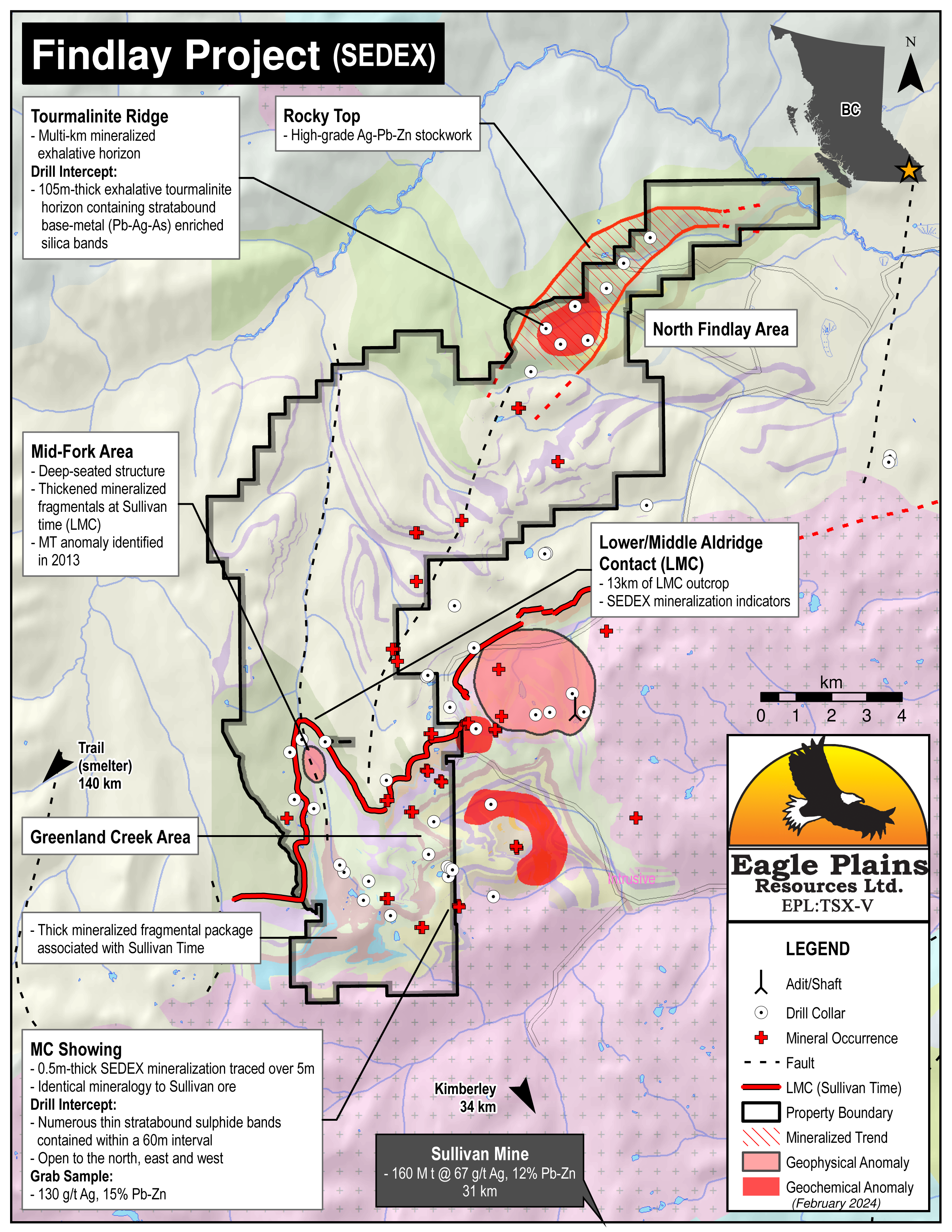
The 11,287 ha Findlay Property is located approximately 30 km north of Kimberley in south-east B.C. The claims overlie the nearest northern exposure of the prospective Lower/Middle Aldridge Formation sedimentary-exhalative (“SEDEX”) stratigraphy which hosted the world-class Sullivan deposit in Kimberley, 70 km NNE. The Sullivan contained 160m tons grading 12% Pb/Zn and 67 g/t Ag valued today at over $35B, and had a mine life of 92 years.
-
- British Columbia
-
- Available for option: No
-
- Zinc,
- Silver,
- Lead
Project Highlights
- Large property package overlying world-class Sullivan deposit stratigraphy
- Numerous Sullivan-type SEDEX mineralized occurrences and alteration
- Encouraging exploration to date with comprehensive database
- Located within the Sullivan Corridor – 30 km north of the Sullivan Mine
- Excellent infrastructure: road-accessible with nearby rail, highway, airport, smelter, hydro
Summary
The 11,287 ha Findlay Property is located approximately 30 km north of Kimberley in south-east B.C. The claims overlie the nearest northern exposure of the prospective Lower/Middle Aldridge Formation sedimentary-exhalative (“SEDEX”) stratigraphy which hosted the world-class Sullivan deposit in Kimberley, 70 km NNE. The Sullivan contained 160m tons grading 12% Pb/Zn and 67 g/t Ag valued today at over $35B, and had a mine life of 92 years.
Geology
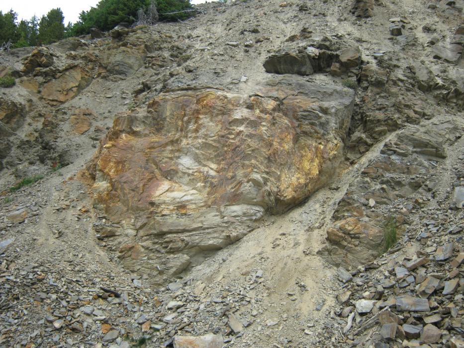
The Findlay Project overlies Aldridge Formation stratigraphy, considered prospective for SEDEX deposits. Structurally, it has been identified as an extension of the same corridor which hosts the world-class Sullivan deposit. The property displays Sullivan-style exhalative tourmaline (boron) horizons, massive fragmental sections, anomalous lead and zinc geochemistry, and base-metal occurrences. This “Sullivan-smoke” occurs throughout the Lower to Upper Aldridge formation and indicates the potential for Sullivan-style mineralization at multiple stratigraphic levels.
History
The Findlay Property has been explored by a number of companies sporadically since the 1930’s both for SEDEX-style base/precious-metals and skarn-related tungsten associated with Cretaceous intrusions.
Findlay Areas
The Findlay Property includes the following targets:
- North Findlay: 100 m thick multi-km scale mineralized and tourmaline-altered exhalative horizon related to hydrothermal venting within the Upper Aldridge stratigraphic interval.
- Greenland Creek: Diamond-drilling intersected numerous thin stratabound sulphide bands associated with albite/garnet/chlorite alteration, some of which display continuity over 60 m, and are open down-dip and along strike. Dating indicates Sullivan-age for lead mineralization in the Greenland Creek area.
- Mid-Fork: Evidence for deep-seated structures including arched gabbros and thickened, mineralized fragmental sequences at or near “Sullivan-time”.
Eagle Plains Exploration
Eagle Plains acquired the project in anticipation of a government-funded regional-scale geophysical survey carried out in 1995. In 1996 Eagle Plains completed the first drill-testing for SEDEX potential which intersected near-surface non-economic sulphide mineralization over 25 metres.
Between 1997 and 2014, several diamond-drill programs, property-scale geological and structural mapping, geochemical sampling, airborne and ground-based geophysics and prospecting have been conducted by various option partners as well as Eagle Plains. More recent exploration efforts have focussed on the Middle-Fork Creek and Phoenix Zone area to gain increased stratigraphic control on the Lower-Middle Aldridge Formation contact (LMC) which is known to outcrop on the property over a 22 km strike-length. The LMC is significant as it is the approximate stratigraphic position of the Sullivan Pb-Zn-Ag deposit.
Future Work
Future work on the property will continue to focus on SEDEX deposit exploration.
Eagle Plains - A Project Generator
Eagle Plains Resources is a project generator with mineral exploration properties of merit that meet qualifying transaction requirements. We facilitate the listing process for capital pool companies and initial public offerings while providing technical expertise for exploration programs. Companies interested in co-operatively exploring any of these projects please contact: Chuck Downie at ccd@eagleplains.com or Mike Labach at mgl@eagleplains.com or call 1 866 Hunt Ore (486-8673).
The Findlay property is currently unavailable for option.
Details
The 11,287 ha Findlay Property is located approximately 30 km north of the city of Kimberley in south-east B.C. The claims were staked in anticipation of an airborne geophysical survey conducted in the fall of 1995 by the Geological Survey of Canada (GSC), and the British Columbia Geological Survey (BCGS).
The claims overlie the nearest northern exposure of prospective Lower/Middle Aldridge Formation sedimentary-exhalative (“SEDEX”) stratigraphy from the world-class Sullivan deposit which contained 160 million tons grading 12% Pb/Zn and 67 g/t Ag. Located in Kimberley, the Sullivan was in production for 92 years and contained metal value in present dollars exceeding 35 billion.
This large project is 100% controlled by Eagle Plains with no overlying royalties or encumbrances.
Project Highlights
- Large property package overlying world-class Sullivan deposit stratigraphy
- Numerous Sullivan-type SEDEX mineralized occurrences and alteration
- Encouraging exploration to date with comprehensive database
- Located within the Sullivan Corridor – 30 km north of the Sullivan Mine
- Excellent infrastructure: road-accessible with nearby rail, highway, airport, smelter, hydro
Geology
The Findlay Project overlies Aldridge Formation stratigraphy, considered prospective for sedimentary-exhalative (“SEDEX”) deposits. Structurally, this area has been identified as an extension of the North Star-Sullivan corridor which hosts the world-class Sullivan deposit 30 km to the south. The Findlay Property displays Sullivan-style exhalative tourmaline (boron) horizons, massive fragmental sections, anomalous lead and zinc geochemistry, and base-metal occurrences. This “Sullivan-smoke” occurs throughout the Lower to Upper Aldridge formation and indicates the potential for Sullivan-style mineralization at multiple stratigraphic levels. Fieldwork by Eagle Plains has identified a number of targets including:
- North Findlay: 105 m thick multi-km scale mineralized and tourmaline-altered exhalative horizon related to hydrothermal venting within the Upper Aldridge stratigraphic interval.
- Greenland Creek: Diamond-drilling by Eagle Plains in 1997 intersected numerous thin stratabound sulphide bands associated with albite/garnet/chlorite alteration, some of which display continuity over 60 m, and are open down-dip and along strike. Dating indicates Sullivan-age for lead mineralization in the Greenland Creek area.
- Mid-Fork: Evidence for deep-seated structures including arched gabbros and thickened, mineralized fragmental sequences at or near “Sullivan-time”.
History
While the bulk of regional exploration for another Sullivan-type deposit occurred in the 1990’s, the Findlay Property has been explored sporadically since the 1930’s by Cominco, Texas Gulf Sulphur, Kerr-Addison Mines, Amax, Four Tops Mining, Billiton Canada and Teck Corp. Commodities sought were SEDEX-style base/precious-metals and skarn-related tungsten associated with Cretaceous intrusions.
Findlay Zones
North Findlay Area
The North Findlay Zone was first recognized as an extensive silver-lead-zinc-copper soil geochemical anomaly by Kerr-Addison in the 1970s. Initial drill-testing of the Doc Minfile occurrence in 1996 by Eagle Plains encountered near-surface anomalous sulphide mineralization over 25 m within a tourmaline-altered succession of Upper Aldridge stratigraphy. Follow-up drilling of the zone in 1997 by Kennecott encountered a 105 m thick package of tourmalinized Upper Aldridge stratigraphy which contained numerous thin, stratabound base-metal-bearing mineralized bands. The 105 m interval returned 0.14% Pb and 5.5 g/t Ag. Further drilling in 1999 defined similar tourmalinite alteration and stratabound mineralized bands as observed in 1997 over a 6 km strike length. The drilling also indicated that the favorable tourmalinite-altered horizons are thickening to the northwest.
Greenland Creek Area
The historic MC showing located within the south-central Greenland Creek area consists of a Sullivan-style massive sulphide lens located within Lower Aldridge stratigraphy. Drilling of the showing in 1997 indicated that sub-surface extension of the mineralization is defined by narrow stratabound massive-sulphide beds which exhibit lateral continuity. Dating indicates Sullivan-age for lead mineralization in the Greenland Creek area. Extensive soil geochemical surveys and limited diamond-drilling have focused on defining the favorable Lower-Middle Aldridge Contact (LMC).
| Sample Type | Results | Description of Zone and Sampling |
|---|---|---|
| Drill | Thin stratabound suphide bands | MC Showing, open to the North, East and West |
| Grab | 130 g/t Ag, 15% Pb-Zn | From MC Showing |
Mid-Fork Area
The Mid-Fork Zone was first recognized as a prospective SEDEX target in 1998 and work focused on the LMC. Anomalous rock, soil and stream-sediment geochemistry coupled with the identification of an extensive fragmental unit at the LMC spurred further exploration in the Mid-Fork Zone including diamond-drilling in 2007. The drilling defined thick fragmental sections coupled with tourmaline alteration and iron-sulphide mineralization at the favorable LMC stratigraphic horizon.
Eagle Plains Exploration
The property had never been drill-tested for SEDEX potential until the Eagle Plains/Miner River JV in 1996. Drilling encountered near-surface non-economic sulphide mineralization over 25 m in the area of the Doc Minfile occurrence.
Between 1997 and 2000, parts of the current Findlay Property were under option to Kennecott Canada, Billiton Canada and Rio Algom. Work by these groups as well as extensive work funded by Eagle Plains included property-scale geological and structural mapping, soil geochemical sampling, prospecting and limited diamond-drilling.
Exploration activity resumed in 2007 when Eagle Plains conducted an 8-hole diamond-drill program in the Greenland Creek and Middle-Fork Creek drainages.
In 2012, geophysical and geochemical surveys were conducted along with a 4-hole drill program in the Greenland Creek Area. In 2013 mapping, geochemical sampling and ground-based geophysics focused on two areas, the far west Middle-Fork Creek and in an area east of the current property boundary. These areas had seen very little exploration work and the goal was to gain increased stratigraphic control on the Lower-Middle Aldridge Formation contact (LMC) which is known to outcrop on the property over a 22 km strike-length. The LMC is significant as it is the approximate stratigraphic position of the Sullivan Pb-Zn-Ag deposit. The program also defined drill targets for the 2014 field season.
2014 Field Program
In July, MMG conducted a two-hole drill program south of the North Findlay area targeting SEDEX base- precious-metal mineralization. Both holes failed to reach target due to poor ground conditions, the program was concluded and MMG terminated the option.
Future Work
Analysis and interpretation of the data gathered in 2014 is ongoing. Results are encouraging and future work on the property will continue to focus on SEDEX deposit exploration.
Eagle Plains - A Project Generator
Eagle Plains Resources is a project generator with mineral exploration properties of merit that meet qualifying transaction requirements. We facilitate the listing process for capital pool companies and initial public offerings while providing technical expertise for exploration programs. Companies interested in co-operatively exploring any of these projects please contact: Chuck Downie at ccd@eagleplains.com or Mike Labach at mgl@eagleplains.com or call 1 866 Hunt Ore (486-8673).
The Findlay property is currently unavailable for option.
Updated April 29, 2024
