Haskins Project
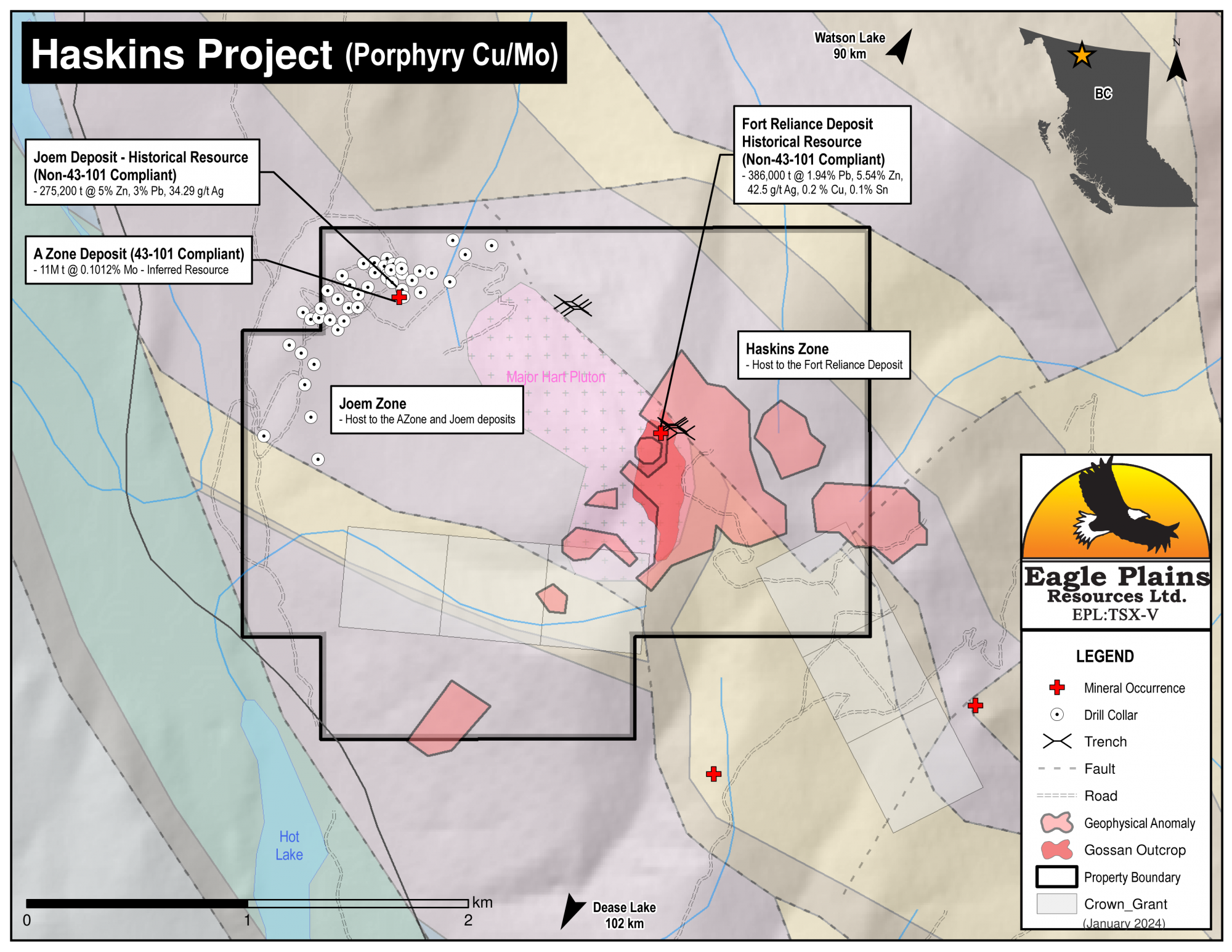
The 578 ha Mount Haskins Property hosts three mineral deposits, the A Zone, a 43-101 compliant inferred resource and the Joem and Fort Reliance historical deposits (non-43-101 compliant) within the property boundary.
Located 90km southwest of Watson Lake, YT and 105km northeast of Dease Lake, BC. the Haskins Property is road accessible via the Old Della Mines Road which branches from Hwy 37 12km north of the Cassiar junction.
The claims are 100% owned by Eagle Plains with a 2% NSR held by Eagle Royalties containing a 1% buy-back clause.
-
- British Columbia
-
- Available for option: Yes
-
- Silver,
- Copper,
- Lead,
- Molybdenum,
- Zinc
Project Highlights
- Host to the 43-101 compliant A Zone inferred resource and the Fort Reliance and Joem Non 43-101 compliant historical resources*
- A Zone Deposit - a 43-101 compliant inferred resource of 11,019,100 tonnes grading 0.1012% Mo
- Joem Deposit - a historical inferred resource (non 43-101 compliant) of 275,200 tonnes grading 5% Zn, 3% Pb and 34.29 g/t Ag
- Fort Reliance Deposit - a historical inferred resource (non-43-101 compliant) of 386,000 tonnes of 1.94% Pb, 5.54% Zn, 42.5 g/t Ag, 0.2 % Cu and 0.1% Sn
- Excellent geology highly prospective for carbonate replacement, skarn, porphyry, and vein mineralization
- Road accessible
- Contact metamorphism of the Kechika siltstones and the Atan Group limestone and quartzites by the intrusion of the granitic Major Hart Pluton caused skarn alteration, as well as the presence of Mo-W stockwork mineralization at lithological contacts and Ag-Pb-Zn bearing veins controlled by cross-cutting fault structures
*Eagle Plains’ management considers these estimates to be historical in nature and cautions that a Qualified Person has not done sufficient work to classify the historical estimates as current mineral resources or mineral reserves in accordance with National Instrument 43-101. These estimates do not comply with current definitions prescribed by National Instrument 43-101 or the Canadian Institute of Mining, and are disclosed only as indications of the presence of mineralization and are considered to be a guide for additional work. The historical models and data sets used to prepare these historical estimates are not available to Eagle Plains, nor are any more recent resource estimates or drill information on the Property
Summary
The 578 ha road accessible Mt. Haskins Property is located 105km NE of Dease Lake, BC. and hosts the A Zone, Joem and Fort Reliance mineral deposits. The claims are 100% owned by Eagle Plains with a 2% NSR held by Eagle Royalties with a 1% buy-back clause.
Project Highlights
- Host to the 43-101 compliant A Zone inferred resource and the Fort Reliance and Joem Non 43-101 compliant historical resources*
- A Zone Deposit - a 43-101 compliant inferred resource of 11,019,100 tonnes grading 0.1012% Mo
- Joem Deposit - a historical inferred resource (non 43-101 compliant) of 275,200 tonnes grading 5% Zn, 3% Pb and 34.29 g/t Ag
- Fort Reliance Deposit - a historical inferred resource (non-43-101 compliant) of 386,000 tonnes of 1.94% Pb, 5.54% Zn, 42.5 g/t Ag, 0.2 % Cu and 0.1% Sn
- Excellent geology highly prospective for carbonate replacement, skarn, porphyry, and vein mineralization
- Road accessible
- Contact metamorphism of the Kechika siltstones and the Atan Group limestone and quartzites by the intrusion of the granitic Major Hart Pluton caused skarn alteration, as well as the presence of Mo-W stockwork mineralization at lithological contacts and Ag-Pb-Zn bearing veins controlled by cross-cutting fault structures
Geology
The Mount Haskins property lies within the northern extension of the Omineca lithotectonic domain, underlain by the sedimentary Cassiar Platform of the Cariboo/Cassiar terrane, which has been intruded by Eocene granitic stocks. Regional structural trends of folding and faulting are dominantly NW.
Mineralization
There are four deposit types in the Mount Haskins area: carbonate replacement, skarn, porphyry, and vein.
History
Sulphide mineralization was discovered on Mount Haskins in the early 1900s. Multiple exploration programs were carried out between 1949 and 2009 included prospecting, geological mapping, rock and soil sampling, geophysical surveys, trenching and diamond drilling resulted in the discovery of 3 mineral deposits.
Zones
The property has 2 zones delineated by their respective mineral occurrences, the Haskins Mountain mineral occurrence of the Haskins Zone is an isolated synclinal outlier of Lower Cambrian Atan Group limestone, underlain by siltstone and occurring near the summit of Mount Haskins with the Eocene Major Hart pluton granite stock occurring to the east. This zone contains the Fort Reliance historical resource of 386,000 tonnes of 1.94% Pb, 5.54% Zn, 42.5 g/t Ag, 0.2 % Cu and 0.1% Sn
The Joem mineral occurrence is located on the NW flank of Mt. Haskin where a 600x100m molybdenite-quartz-muscovite stockwork is developed in granitic rocks and contains an inferred resource estimate of 11,019,100 tonnes grading 0.1012% Mo. Just to the north of the molybdenum zone 2 northwest trending pyrrhotite-sphalerite-galena-chalcopyrite massive skarn lenses occur in calc-silicate hornfels with common sericitic alteration and contain a historical resource of 275,200 tonnes grading 5% Zn, 3% Pb and 34.29 g/t Ag.
Eagle Plains Exploration
In 2023 Eagle Plains Resources compiled the available data for the Mount Haskins property area highlighting zones of interest and under-explored areas warranting further exploration including:
- A Tier 2 compilation to digitize historic work into a comprehensive database
- Geological modelling of the A Zone
- A magnetic and EM geophysical survey across the entire tenure
- Field work consisting of prospecting and soil sampling
- Trenching and/or diamond drilling of prospective targets resulting from the above work
Eagle Plains - A Project Generator
Eagle Plains Resources is a project generator with several mineral exploration properties of merit that meet qualifying transaction requirements. We facilitate the listing process for capital pool companies and initial public offerings while providing technical expertise for exploration programs. Companies interested in co-operatively exploring any of our projects please contact: Chuck Downie at ccd@eagleplains.com or Mike Labach at mgl@eagleplains.com or call 1 866 Hunt Ore (486 8673).
The Haskins Project is currently available for option.
Details
The 578 ha Mount Haskins Property hosts three mineral deposits, the A Zone, a 43-101 compliant inferred resource and the Joem and Fort Reliance historical deposits (non-43-101 compliant) within the property boundary.
Located 90km southwest of Watson Lake, YT and 105km northeast of Dease Lake, BC. the Haskins Property is road accessible via the Old Della Mines Road which branches from Hwy 37 12km north of the Cassiar junction.
The claims are 100% owned by Eagle Plains with a 2% NSR held by Eagle Royalties containing a 1% buy-back clause.
Project Highlights
- Host to the 43-101 compliant A Zone inferred resource and the Fort Reliance and Joem Non 43-101 compliant historical resources*
- A Zone Deposit - a 43-101 compliant inferred resource of 11,019,100 tonnes grading 0.1012% Mo
- Joem Deposit - a historical inferred resource (non 43-101 compliant) of 275,200 tonnes grading 5% Zn, 3% Pb and 34.29 g/t Ag
- Fort Reliance Deposit - a historical inferred resource (non-43-101 compliant) of 386,000 tonnes of 1.94% Pb, 5.54% Zn, 42.5 g/t Ag, 0.2 % Cu and 0.1% Sn
- Excellent geology highly prospective for carbonate replacement, skarn, porphyry, and vein mineralization
- Road accessible
- Contact metamorphism of the Kechika siltstones and the Atan Group limestone and quartzites by the intrusion of the granitic Major Hart Pluton caused skarn alteration, as well as the presence of Mo-W stockwork mineralization at lithological contacts and Ag-Pb-Zn bearing veins controlled by cross-cutting fault structures
*Eagle Plains’ management considers these estimates to be historical in nature and cautions that a Qualified Person has not done sufficient work to classify the historical estimates as current mineral resources or mineral reserves in accordance with National Instrument 43-101. These estimates do not comply with current definitions prescribed by National Instrument 43-101 or the Canadian Institute of Mining, and are disclosed only as indications of the presence of mineralization and are considered to be a guide for additional work. The historical models and data sets used to prepare these historical estimates are not available to Eagle Plains, nor are any more recent resource estimates or drill information on the Property
Geology
The Mount Haskins property lies within the northern extension of the Omineca lithotectonic domain, underlain by the sedimentary Cassiar Platform of the Cariboo/Cassiar terrane, which has been intruded by Eocene granitic stocks. The platform is made up of the Cambrian-Ordivician Kechika Group and Lower Cambrian Atan Group of clastic sediments. Regional structural trends of folding and faulting are dominantly northwesterly, with local secondary northeast-trending faulting.
The peak of Mount Haskins is dominated by the alkali feldspar granitic Major Hart Pluton. The granite stock has a coarse-grained porphyritic core which grades to fine, locally silicified granitic marginal phases with an aplitic chill margin. The pluton intruded into a sedimentary suite of rocks comprised of the Kechika Group siltstones, and the Boya Formation quartzites and Rosella Formation limestones of the Atan Group. The argillaceous rocks of the Kechika Group have been pervasively metamorphosed to hornfels nearing the porphyry.
The package of Atan Group sediments is composed of interbedded quartzite with phyllite and limestone with dolostone, northwest to northerly striking, moderate to steeply southwest dipping. The Lower Cambrian Rosella Formation consists of thin to thick bedded limestone, partially replaced by coarse, orange-weathered secondary dolomite, with recessive slatey to muddy interbeds. The limestone, commonly folded, may be recrystallized or altered to skarn or chert due to the presence of the nearby porphyry. The Rosella limestone rests conformably above the Boya Formation, which occurs as rubbly subcrop. The Boya Formation is a siliciclastic sequence consisting predominantly of quartzite with interbedded slate and siltstone, likely representing a shallow marine fan-top facies.
Pyrrhotite and sphalerite are the most abundant sulphides reported on the property, while galena, pyrite, arsenopyrite, and chalcopyrite may also be present. The patterns of mineralization and alteration are related to the emplacement of the granitoid magma, creating complex adjacent hydrothermal systems. Four types of mineralization associated with the granitic intrusion have been described:
- metasomatized metapelitic hornfels hosting stockwork molybdenum-tungsten mineralization
- series of northwest and northeast trending faults which control sulphides-skarn development and Ag-Pb-Zn bearing veins
- quartz-molybdenite stockworks within the granitic pluton, concentrated along the peripheral edge
- massive sulphide lenses and replacement beds associated with skarn alteration within sedimentary units and at their contacts
The granitic intrusion has a chilled peripheral shell of mixed carbonate skarn with elevated molybdenum and tungsten, alongside minor porphyry style mineralization within the intrusive rocks. Dykes originating from the principal intrusion were present close to the Fort Reliance mineral zone and it is likely that similar dykes will be found elsewhere in proximity to skarn-type metallic mineralization.
Polymetallic carbonate-replacement deposits and associated skarn mineralization form by the reaction of high temperature hydrothermal fluids (>>250° C) generated in igneous (i.e. porphyry) environments with carbonate bearing country rocks. The deposits form when magmatic-hydrothermal fluids expelled from cooling magmas react chemically with carbonate-rich sedimentary rocks.
History
Sulphide mineralization was discovered on Mount Haskins in the early 1900s with initial exploration work of geological mapping, trenching and rock sampling being conducted in 1949. This work resulted in the discovery of the Main Zone fault that trends northwest, dipping steeply to the northeast and hosting continuous ore for 300 ft with an average grade of 8.46% Zn, 2.68% Pb, 2.66 oz/t Ag.
The claims were restaked in 1954 and five crown grant claims were established within the tenure area at this time and remain in good standing.
In 1965 U.S. Steel reported ore reserves in excess of 386,000 tons at 1.94% Pb, 5.54% Zn. 42.5 g/t Ag, 0.2 % Cu and 0.1% Sn at the Fort Reliance Deposit in the Haskins Zone.
Della Mines Ltd. were reported to have conducted multiple drill programs between 1968 and 1971, completing approximately 50 holes, however this work and their results are found in private reports and have not been published.
Iso Mining published an indicated resource at the A Zone in 1971 which was upgraded to 43-101 standards by Velocity Minerals in 2009.
In 1973, Dalziel conducted geological mapping and a total heavy metal soil survey in the south east portion of the property. Mineralization was restricted to boundaries between quartzites and limestone, due to contact metamorphism from the granite porphyry. A weak northwest trend was observed with no strong zinc anomalies detected.
In 1976 Della Mines completed four drill holes (119m) at the A Zone. Hole A-3 intersected up to 80% magnetite from 6.1-25.9m, returning 4.75% Zn. Hole A-1 intersected skarn, with a sample of massive pyrrhotite returning 13% Zn at 9.1m and a chert sample from 24.3-30.5m returning 2.4 oz/t Ag.
In 1996 B. Ernewein collected 7 float samples typical of polymetallic skarn deposits from the eastern portion of the property one of which returned 4,485 ppm Cu, 18,127 ppm Pb, 82,929 ppm Zn and 284.2 ppm Ag.
In 1997, Demand Gold Ltd. conducted a magnetometer survey at the A Zone followed by an 8-hole 461.4m drill program. The best drill results returned 0.494% Cu, 1.77% Pb and 4.74 oz/t Ag over 1 m, 24.85% Zn over 0.6 m and 0.328% Mo over 1 m.
Diakow and Hope conducted geological mapping and prospecting in the SE portion of the property in 2006. Rock samples were collected from old workings consisting of massive pyrrhotite skarn rich in copper minerals, and large blocks of massive sphalerite-galena. Soil sample assays returned over 10,000 ppm Zn and 30 ppm Mo, with up to 4,000 ppm Cu and 20 ppm Ag.
In 2008/09 Velocity Minerals Ltd. conducted drill programs intersecting molybdenite in 12 of 13 holes in the first program of 3,427m. This confirmed molybdenum mineralization from about 100 m depth with an average grade around 0.08% Mo leading to a 43-101 compliant inferred resource of 11,019,100 tonnes grading 0.1012% Mo using a cut-off grade of 0.05% Mo at the A Zone. Four holes (783m) drilled in 2009 to locate the edges of the ore deposit did not intersect significant mineralization to expand the resource.
In 2008 Pacific Bay Minerals conducted an airborne VLF-EM geophysical survey that included a portion of the SE part of the property. Data was consistent with sedimentary backgrounds, with northwest-southeast trends confirming mapped structural orientation with magnetic anomalies associated with geological contacts and structures. Several magnetic responses correlated with topography, suggesting near horizontal beds. Many trends terminate or are offset by faults which coincide with drainage structures. An extreme magnetic low was observed SE of the peak of Mount Haskins.
Zones
Haskins Zone
The Haskins Mountain mineral occurrence, an isolated synclinal outlier of Lower Cambrian Atan Group limestone, underlain by siltstone, occurs near the summit of Mount Haskins. To the east lies the Eocene Major Hart pluton granite stock. A northwest-trending fault along the northeast end of the limestone separates Atan Group rocks from Upper Proterozoic Ingenika Group clastics to the northeast.
Massive pyrrhotite-rich garnet skarn occurs at the carbonate-clastic contact, along the fault zone and in several stratigraphically lower horizons in the upper 30 m of the siltstone. Mineralization includes abundant sphalerite and lesser amounts of chalcopyrite, galena, arsenopyrite and beryl. One drill intersection from 1949 assayed 67.2 g/t Ag, 9.0% Zn and 4.5% Pb over 3.6 m.
The Haskin Zone includes the Fort Reliance historical resource of 386,000 tonnes of 1.94% Pb, 5.54% Zn, 42.5 g/t Ag, 0.2 % Cu and 0.1% Sn, which has been prospected and trenched on surface, hosting strong pyrrhotite with sphalerite and galena.
Joem Zone
The Joem mineral occurrence is located on the northwestern flank of Mount Haskin where a molybdenite-quartz-muscovite stockwork is developed in granitic rocks and extends into the adjacent cherty sediments. The molybdenum zone measures approximately 600x100 m and contains an inferred resource estimate of 11,019,100 tonnes grading 0.1012% Mo. Reports also state elevated levels of tungsten, tin and bismuth in the molybdenite mineralized areas.
Two northwest trending pyrrhotite-sphalerite-galena-chalcopyrite massive skarn lenses occur in calc-silicate hornfels with common sericitic alteration just to the north of the molybdenum zone and contains a historical resource of 275,200 tonnes grading 5% Zn, 3% Pb and 34.29 g/t Ag.
Eagle Plains Exploration
In 2023 Eagle Plains Resources compiled the available data for the Mount Haskins property area and highlighted zones of interest and under-worked areas which warrant further exploration.
Future Work
Recommendations for further exploration work at the Mount Haskins project includes the following:
- A Tier 2 compilation to completely digitize historic work and record data within a single, comprehensive database
- Geological modelling and targeting of the “A Zone” using historic diamond drill logs and analytical assay results
- A magnetic and EM geophysical survey across the entire tenure to determine magnetic and conductive anomalies
- Field work consisting of prospecting and geochemical soil sampling with a focus on lithological contacts, important structural zones and areas of intense alteration
- Evaluation of mineral occurrences
- Evaluation of access roads
- Trenching or diamond drilling of prospective targets resulting from the above work
- Infill drilling of historic holes to confirm/replicate previous results
Eagle Plains - A Project Generator
Eagle Plains Resources is a project generator with several mineral exploration properties of merit that meet qualifying transaction requirements. We facilitate the listing process for capital pool companies and initial public offerings while providing technical expertise for exploration programs. Companies interested in co-operatively exploring any of our projects please contact: Chuck Downie at ccd@eagleplains.com or Mike Labach at mgl@eagleplains.com or call 1 866 Hunt Ore (486 8673).
The Haskins Project is currently available for option.
Updated April 30, 2024