Ice River Project
The 2310 ha Ice River Property, located 45km east of Golden, B.C., covers the eastern limit one of the largest and best preserved alkaline intrusive complexes in the world which contains base- and precious- metals, Rare Earth Elements (“REE’s”) and industrial metal mineralization.
-
- British Columbia
-
- Available for option: Yes
-
- Rare Earth Elements,
- Industrial Minerals,
- Lead,
- Zinc,
- Gold,
- Niobium
Project Highlights
- Exceptional geology favourable for base, precious, rare and high tech metals (REE, Nb, Zr)
- Numerous untested geochemical anomalies
- Encouraging new base metal and REE showings located in the last 5 years
- Drill ready targets for rare earth elements, nepheline syenite, and niobium
- Forest Service road access to property boundary with nearby infrastructure
Summary
The 2310 ha Ice River Property, located 45km east of Golden, B.C., covers the eastern limit one of the largest and best preserved alkaline intrusive complexes in the world which contains base- and precious- metals, Rare Earth Elements (“REE’s”) and industrial metal mineralization.
Project Highlights
- Exceptional geology favourable for base, precious, rare and high tech metals (REE, Nb, Zr)
- Numerous untested geochemical anomalies
- Encouraging new base metal and REE showings located in the last 5 years
- Drill ready targets for rare earth elements, nepheline syenite, and niobium
- Forest Service road access to property boundary with nearby infrastructure
Geology
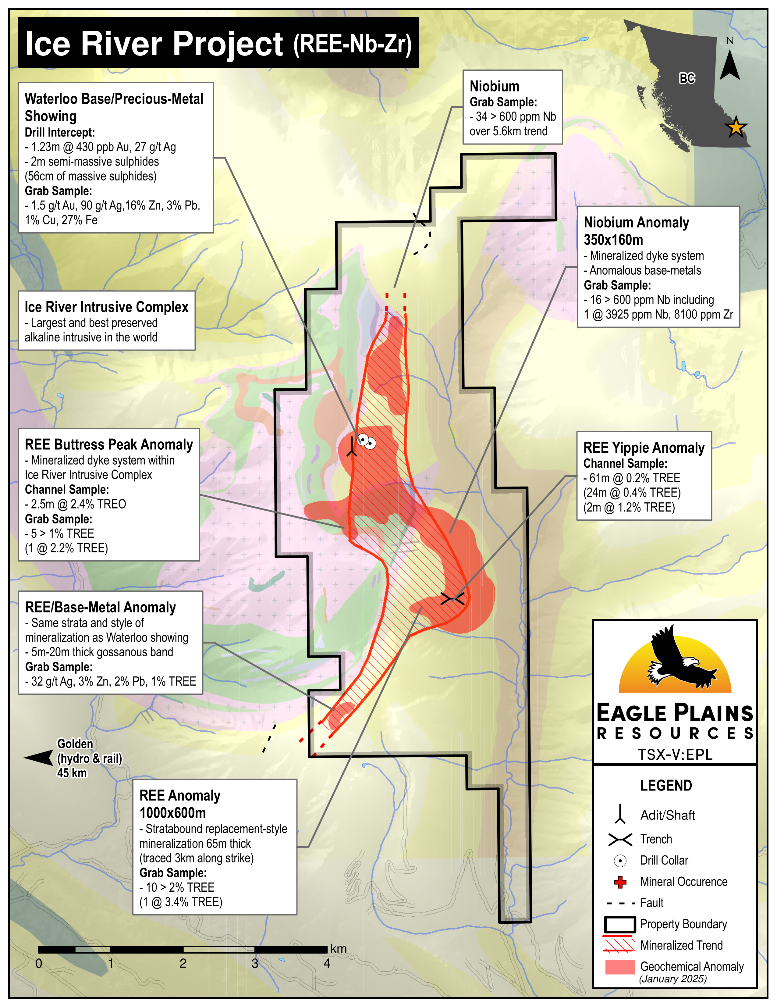
The Ice River Complex (IRC) is a large, J-shaped intrusion. Within the complex, two distinct suites are present; an early, rhythmically layered, syenite intrusion cored by a carbonatite plug. It is later zoned by a cross-cutting syenitic carbonitite.
Ice River Complex Zones
Within the complex several significant mineralized zones are present and distinguished by consisting of Rare Earth Elements, Niobium and base- and precious-metals.
History
The Ice River property has seen geologic investigation since the early 1900s due to the rarity of and unique geological and geochemical characteristics of alkaline intrusive complexes. Associated with this complex is considerable economic mineral potential.
2005 - 2012 Eagle Plains conducted exploration programs consisting of geologic traverses, mapping, geochemical and geophysical surveys and diamond drilling which resulted in:
- Verifying mineral potential for industrial or rare metals (including titanium, niobium, zirconium) and a variety of rare earth elements
- Significant Pb, Zn, Ag, and Cu mineralization in drill intercepts in the Waterloo area with notable gold values up to 340 ppb
- Identifying a significant mineralized base-metal/REE stratigraphic unit that is interpreted to extend up to at least 4 km. This unit is coincident with geochemical anomalies, namely:
- Waterloo historic showing
- A new stratabound base-metal sulphide showing
- The large (1000 m x 600 m) Buttress Peak REE anomalous zone containing the new Yippie showing
- The 350m x 160m stratabound Nb anomalous zone
| Sample Type | Results | Description of Zone |
|---|---|---|
| Rock | 3% Total Rare Earth Oxides | Within the IRC intrusion halo |
| Rock | 5600 g/t Niobium/Columbian Oxide | Within the IRC intrusion halo |
| Chip | 2.5m @ 2.4% TREO | Within the IRC intrusion halo |
| Rock samples over 700m | 5 of 18 samples > 1% and up to 2.28% TREE | Buttress Peak REE zone |
| 100m chip and channel, (61.4m true thickness) | - 61.4m of 0.22% TREE - Including: 24m of 0.41% TREE - Including: 2m of 1.28% TREE and several 2m intervals over 0.5% TREE |
Yippie showing |
| Rock | Six anomalous samples up to: 2.72% Zn, 2.41% Pb and 31.8 g/t Ag + all are REE anomalous up to 1% TREE |
From the REE/base-metal showing of strata-bound sulphides near the southern limit of the property |
Future Work
Three targets have been identified for follow-up work:
- Detailed prospecting, sampling and drilling of two anomalies, the Buttress Peak REE replacement anomaly that is open in two directions and the 350 m x 160 m Nb anomaly.
- Detailed mapping/prospecting and rock sampling of the new base-metal stratabound mineralization and associated REE along the south portion of the property.
Eagle Plains - A Project Generator
Eagle Plains Resources is a project generator with several mineral exploration properties of merit that meet qualifying transaction requirements. We facilitate the listing process for capital pool companies and initial public offerings while providing technical expertise for exploration programs. Companies interested in co-operatively exploring any of our projects please contact: Chuck Downie at ccd@eagleplains.com or Mike Labach at mgl@eagleplains.com or call 1 866 Hunt Ore (486 8673).
Details
The Ice River Property is situated 45 km east of Golden, B.C. and is currently accessed by helicopter. Forest Service roads reach to within 5 km of the property boundary. The 2310 ha property was staked in 2003 and is owned 100% by Eagle Plains Resources with a 2% NSR held by Eagle Royalties containing a 1% buy-back clause.
The Ice River Complex (IRC) is one of the largest and best preserved alkaline intrusive complexes in the world. It has been the focus of several projects from both industrial and academic perspectives since its discovery around 1900. Mineral collectors have long been drawn to the area which is known for its sodalite-bearing syenites and specimen-quality zeolites.
Historical prospecting in the area focussed on several base- and precious-metal showings in the contact aureole of the IRC. Field work on the property by Eagle Plains since 2006 has established widespread distribution of Rare Earth Elements (“REE’s”) and Niobium mineralization.
Project Highlights
- Exceptional geology favourable for base, precious, rare and high-tech metals (REE, Nb, Zr)
- Numerous untested geochemical anomalies
- Encouraging new base-metal and REE showings located in recent programs
- Drill-ready targets for rare earth elements, nepheline syenite, and niobium
- Forest Service road access to property boundary with nearby infrastructure
Geology
The Ice River Complex (IRC) is a large, J-shaped alkaline intrusion, approximately 18 km long with a total exposure of 29 sqkm. Within the complex, two distinct suites are present: an early, rhythmically layered, feldspar-free intrusion of jacupirangite, ijolite, and urtite, cored by a carbonatite plug and cross-cut by carbonatite dykes rich in mafic silicates and oxides; and a later zoned and cross-cutting syenitic series, associated with a zeolite and feldspar-bearing carbonatite. The alkaline rocks intruded Cambrian and Ordovician shales and carbonates of the Chancellor, Ottertail and McKay Formations.
The western half of the 2.8 km wide by 6.0 km long property is dominated by intrusives of the zoned syenite complex and subordinate but significant occurrences of the layered mafic complex. The central to eastern parts of the property, including the eastern flanks of Zinc and Buttress peaks down to the valley bottom, is dominated by limestone of the Ottertail formation. The Waterloo prospect lies in the centre of the property area, within the Ottertail formation, approximately 350 m east of the northerly-trending contact with the syenite complex.
History
The Ice River property overly a sequence of rocks that have seen geologic investigation since the early 1900’s due to the unique geological and geochemical characteristics of the area and the considerable economic potential located there. Various groups have completed programs in the area, first described in 1914 by J.A. Allan in GSC Memoir No. 55. The area is also of great interest to mineral collectors primarily for sodalite, and also for a wide variety of rare minerals associated with alkaline complexes.
Ice River Complex Zones
Within the IRC, several distinct anomalous mineralized zones are present:
Rare Earth Elements
REE replacement mineralization has been recently discovered along East IRC contact. A mineralized zone 65 m thick and traced along strike over 3 km is consistent with multi-percent-REE rock samples from a 1000m x 600m REE geochemical anomaly. This zone comprises broad replacement-style mineralization within host limestones in contact with the IRC. This is located along the SE flank of Buttress Peak.
Niobium
Nb mineralization in sodalite-syenite dykes has been identified in an area 350m x 160m approximately 300 m north of the REE replacement zone. Samples are also anomalous in Zr, Pb, and Zn. This is located along the NE Flank of Buttress Peak.
Base and Precious Metals
Two zones of metal-bearing sulphide mineralization within the property are known:
- The Waterloo Showing consists of sulfide horizons exposed in two historical adits with grab samples returning assays up to 3.69% Pb, 16.10% Zn, 1.59% Cu, 27.30% Fe, 90 g/t Ag and 1.5 g/t Au.
- A REE/base-metal anomaly consisting of stratabound sulphides in association with REE mineralization has recently been discovered in the SE part of the property. The mineralization style is similar to the Waterloo showing and is significant since it is located 4 km to the south in the same stratigraphic horizon. Fieldwork in this area has been limited but outcrop exposure is good. Samples returned up to 2.72% Zn, 2.41% Pb and 31.8 g/t Ag, with REE values up to 1% Total REE.
Eagle Plains Exploration
Eagle Plains commenced exploration activities in 2005. Geologic traverses successfully located and verified mineral potential for industrial or rare metals (including titanium, niobium, zirconium), a variety of rare earth elements, the semiprecious gemstone sodalite and dimension stone. Many occurrences of zeolite mineralization/alteration were also noted throughout the property area.
In 2006 geological mapping at the Waterloo Showing identified a significant mineralized stratigraphic sub-unit that is now known to extend up to 4 km to the southern extent of the property. Mapping also revealed the presence of two previously unreported zones rich in sodalite syenite.
The 2007 exploration program consisted of soil sampling, prospecting and mapping as well as a five-hole diamond-drill program which successfully verified significant Pb, Zn, Ag, and Cu mineralization with notable gold values up to 340 ppb.
The 2008 exploration program consisted of geologic mapping and sampling outside the distinct mineralized zones sampled previously and within the area of intrusions. This exploration led to focussing efforts on the alteration halo that make up the now known distinct zones of mineralization.
| Sample Type | Results | Description of Zone and Sampling |
|---|---|---|
| Rock Sample | 3% Total Rare Earth Oxides | Within the IRC intrusion halo |
| Rock Sample | 5600 g/t Niobium/Columbian Oxide | Within the IRC intrusion halo |
| Channel Sample | 2.5m @ 2.4% TREO | Within the IRC intrusion halo |
In 2009 exploration continued to focus on REE, Nb and base-metals associated with the intrusions of the Ice River Complex (IRC). This consisted of geochemical surveying, soil sampling, mapping, prospecting, and rock and stream sediment sampling. By this time the styles of mineralization were well established with the most prospective being that associated with syenite and carbonatite dykes and zones that have been extensively zeolite and/or fennite altered.
Fieldwork in 2010 consisted of prospecting, geologic mapping and rock sampling. The purpose of the program was to follow-up the large REE soil anomaly discovered along the southeast flank of Buttress Peak.
| Sample Type | Results | Description of Zone |
|---|---|---|
| Rock | 5 of 18 samples collected over 700m returned > 1% and up to 2.28% TREE | From the Buttress Peak REE Anomaly |
2012 Field Program
Fieldwork in 2012 consisted of two components:
- Detailed mapping/prospecting, channel sampling, and infill soil geochemical sampling in the vicinity of the Buttress Peak REE anomaly
- Property-scale prospecting, mapping, and soil and silt geochemical sampling from the Buttress Peak REE anomaly to the tenure limit 1.8 km to the south.
The soil geochemical results along the east flank of Buttress peak revealed a stark ovoid-shaped REE-Zn-Mn-Ba-Mo anomaly 1000 m x 600 m in size and open in 2 directions. Within this anomaly, a new showing, the Yippie, was discovered and a 100 m (64 m true thickness) continuous channel & chip sample taken over it. The Yippie along with another new REE/base-metal showing of strata-bound sulphides discovered near the Southern limit of the property resulted in:
| Sample Type | Results | Description of Zone and Sampling |
|---|---|---|
| 100m channel sample, (61.4m true thickness) | 61.4m - 0.22% TREE - including 24m - 0.41%, - including 2m of 1.28% - several other 2m intervals of over 0.5% ppm |
From the Yippie showing |
| Rock Sample | Six samples returned up to: 2.72% Zn, 2.41% Pb and 31.8 g/t Ag + all are REE anomalous up to 1% TREE |
From the REE/base-metal showing of strata-bound sulphides near the southern limit of the property |
It is significant to note that the stratabound REE mineralization at the Yippie showing within the Buttress Peak anomaly, the new REE/base-metal showing of strata-bound sulphides, the historic Waterloo showing and the Nb geochemical anomaly appear to occur at the same stratigraphic horizon. The Waterloo Showing is located approximately 3 km to the north of the Yippie showing and 4 km north of the new REE/base-metal showing. Approximately half-way between is a significant 350 m x 160 m Nb anomaly.
Future Work
Recommendations for three targets that are of interest at this stage of exploration:
- Follow-up detailed prospecting and sampling of the REE replacement anomaly that is open in two directions. Diamond-drill testing of this anomaly along the NE trend to determine continuity of mineralization along the 1000m anomalous soil geochemical strike-length.
- Follow-up detailed prospecting, rock sampling and 300m of drilling targeting the 350m x 160m Nb anomaly associated with the sodalite-syenite dykes. This anomaly is located approximately mid-way between the Yippie and Waterloo showings which are interpreted to be hosted in the same stratigraphic sequence.
- Detailed follow-up mapping/prospecting and rock sampling of the new base-metal stratabound mineralization and associated REE along the south portion of the property.
Eagle Plains - A Project Generator
Eagle Plains Resources is a project generator with several mineral exploration properties of merit that meet qualifying transaction requirements. We facilitate the listing process for capital pool companies and initial public offerings while providing technical expertise for exploration programs. Companies interested in co-operatively exploring any of our projects please contact: Chuck Downie at ccd@eagleplains.com or Mike Labach at mgl@eagleplains.com or call 1 866 Hunt Ore (486 8673).
Updated January 10, 2025
Photos