Kalum Project
The 2871 ha Kalum Property is located 35 km NW of Terrace, BC. Numerous high-grade, vein-type gold occurrences have been explored over 80 years for high-grade stand-alone mineralization. Eagle Plains has consolidated these gold occurrences into one property. The property is located within 4km of the Northwest Transmission Line and accessed by a network of logging roads.
-
- British Columbia
-
- Available for option: Yes
-
- Gold,
- Silver,
- Copper
Project Highlights
- Intrusion-related gold target
- Encouraging exploration to date including mineralized drill intercepts
- Excellent geology with multiple high-grade gold +/- occurrences
- Numerous untested coincident geochemical and geophysical anomalies
- Excellent infrastructure - highway, logging roads, NW Transmission Line, 35 km to Terrace
Summary
The 2871 ha Kalum Property is located 35 km NW of Terrace, BC. Numerous high-grade, vein-type gold occurrences have been explored over 80 years for high-grade stand-alone mineralization. Eagle Plains has consolidated these gold occurrences into one property.
The property is located within 4km of the Northwest Transmission Line and accessed by a network of logging roads.
Project Highlights
- Intrusion-related gold target
- Encouraging exploration to date including mineralized drill intercepts
- Excellent geology with multiple high-grade gold +/- occurrences
- Numerous untested coincident geochemical and geophysical anomalies
- Excellent infrastructure - highway, logging roads, nearby NW Transmission Line, 35 km to Terrace
Geology
The Kalum property is centered on an 8-by-12 km irregularly shaped granodioritic pluton of the Coast Crystalline Complex. This pluton and many associated smaller intrusions were emplaced into Upper Jurassic to Lower Cretaceous Bowser Lake Group sedimentary rocks. Intrusions range in composition from quartz monzonite to granodiorite and diorite and vary in size from small stocks to large batholiths, contacts between the intrusions and sedimentary rocks are generally irregular.
Exploration History
Eagle Plains’ acquisition in 2003 represents the first time these mineral showings have been consolidated and evaluated as a whole by a single owner. For 80 years prior each showing area had been worked by various operators separately.
Eagle Plains has completed 5 significant exploration programs on the Kalum claims that have included: geological mapping, prospecting, rock, channel, stream sediment and soil sampling, airborne and ground-based geophysical surveys and diamond-drilling.
Most of the high-grade mineralization on the property is located near the margins of the main Allard Pluton, both within the granodiorite and in the surrounding sedimentary country rocks. This indicates that most fluid-flow was focused near the intrusion margins, and in country-rock roof pendants around the main pluton. Only a relatively small portion of the sedimentary-intrusive contact zone has been explored to date.
These programs have been very successful and defined numerous new, high-grade zones of Au-Ag mineralization including new showings and confirming that the Kalum property is highly prospective for economically viable Au-Ag epithermal vein-type deposits.
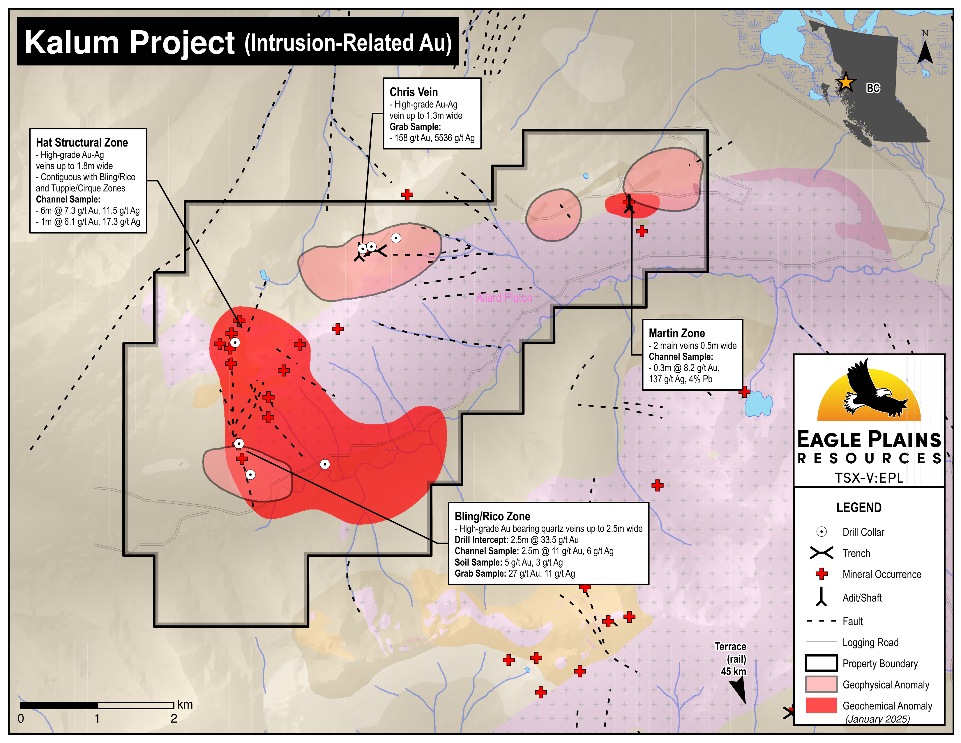
Mineralized Zones
The Kalum Property is characterized by 4 zones of mineralization. It is interpreted that the majority of Hat Zone showings are structurally linked representing a single large-scale mineralized system over 1 sq. km with the zones structurally repeating on a scale of 50 m over a thickness of 300 m, an excellent target for a bulk-tonnage, low-grade, open-pit operation. Furthermore, the Bling/Rico Zone is interpreted to be structurally linked with the Hat Zone as well. Below is an exploration highlight from each:
| Sample Type | Results | Zone |
|---|---|---|
| Channel | 6m @ 7.3 g/t Au and 11.5 g/t Ag | Hat Structural Zone |
| Diamond drill - 101.8m to 104.3m | 2.5m @ 33.5 g/t Au | Bling/Rico |
| Channel sample | Systematic channel sampling along 300m extent of exposed Chris vein averaged 11.2 g/t Au, 80 g/t Ag, and 1.4% Pb |
Chris Vein up to 1.3m wide |
| Channel | 0.3m @ 8.2 g/t Au, 137 g/t Ag and 4.0% Pb | Martin |
Future Work
The geology, alteration, and structure suggest that the Bling-Rico Zone is a large-scale continuous structural/hydrothermal feature that has acted as a conduit for precious-metal-bearing hydrothermal fluids. Further work is required to determine what is controlling deposition.
A relatively small portion of the sedimentary-intrusive contact zone has been explored to date. Potential exists along the unexplored contact zones, especially in areas that have a favorable geophysical signature. In areas of known mineralization, new discoveries are possible through soil geochemical sampling, prospecting and airborne geophysics. Ground work has been greatly aided due to the low annual snow pack and recession of glaciers which has exposed many mineralized veins, structures and favorable geology for the first time in modern history.
Eagle Plains - A Project Generator
Eagle Plains Resources is a project generator with several mineral exploration properties of merit that meet qualifying transaction requirements. We facilitate the listing process for capital pool companies and initial public offerings while providing technical expertise for exploration programs. Companies interested in co-operatively exploring any of our projects please contact: Chuck Downie at ccd@eagleplains.com or Mike Labach at mgl@eagleplains.com or call 1 866 Hunt Ore (486 8673).
Updated April 29, 2024
Details
The 2871 ha Kalum Property is located 35 km NW of Terrace, British Columbia. A number of high-grade, vein-type gold occurrences have been explored by various operators over the past 80 years with all efforts being directed toward discovery of high-grade stand-alone mineralization.
The property is located 4 km west of the Northwest Transmission Line and accessed by a network of logging roads. The project is 100% owned by Eagle Plains with a 2% NSR held by Eagle Royalties containing a 1% buy-back clause.
Project Highlights
- Intrusion- related gold target
- Encouraging exploration to date including mineralized drill intercepts
- Excellent geology with multiple high-grade gold +/- occurrences
- Numerous untested coincident geochemical and geophysical anomalies
- Excellent infrastructure - highway, logging roads, nearby hydro power-line, 35 km to Terrace
Geology
The Kalum property is located on an 8-by-12 km irregularly shaped granodioritic pluton of the Coast Crystalline Complex. This pluton and many associated smaller intrusions were emplaced into Upper Jurassic to Lower Cretaceous Bowser Lake Group sedimentary rocks.
More specifically, it is located on the NE-trending contact between dioritic intrusions of the Cretaceous-age Coast Crystalline Complex, and the fine-grained sedimentary and volcanic sequence of the Upper Jurassic to Lower Cretaceous-age Bowser (Lake) Group. Intrusions range in composition from quartz monzonite to granodiorite and diorite and vary in size from small stocks to large batholiths, contacts between the intrusions and sedimentary rocks are generally irregular. Hypabyssal rocks, in the form of porphyritic, aplitic, and basaltic dikes and sills, intrude both the sediments and Coast granitoids. On the northern part of the Property, in the area of the Chris occurrence, cross-cutting rhyolite dykes have also been reported
History
The current Eagle Plains land position represents the first time the mineral showings have been consolidated and evaluated as a whole by a single owner, prior to this each showing area had been worked by various operators separately. A brief history of each zone follows:
Kalum Zones
The Kalum Property has 4 exploration zones, the following are exploration highlights including Eagle Plains programs:
Hat Structural Zone (“HSZ”)
A geochemical survey indicating anomalous arsenic and silver led to the discovery of the Hat showing in 1980. Further sampling, prospecting, and mapping located additional quartz veins with arsenopyrite, galena, sphalerite, and pyrite. Exploration concluded that precious-metal values are associated with quartz-arsenopyrite veins and these in turn appear to be associated with a diorite intrusion. Sampling and mapping of the most highly mineralized veins resulted in the values below:
| Sample Type | Results | Description of Zone and Sampling |
|---|---|---|
| Channel | 6.0m @ 7.3 g/t Au and 11.5 g/t Ag | Babit Showing |
| Channel | 1m @ 6.1 g/t Au and 17.3 g/t Ag | 5000 Vein |
| Channel | 0.7m @ 4.8 g/t Au and 380 g/t Ag | Pick Vein |
| Channel | 0.45m @ 7.3 g/t Au and 1077 g/t Ag | 4700 Vein |
| Channel | 0.3m @ 2.7 g/t Au and 72.9 g/t Ag | Trango Vein |
Bling/Rico Zone
Discovered in 2002 by Eagle Plains, it is thought to represent a complex structural zone. The main sub-vertical fault zone is 5 to 10 m wide and is locally heavily pyritized and silicified. Prospecting and mapping has revealed high-grade Au bearing quartz veins up to 400 m along strike from the main Rico vein. It is interpreted that the Bling/Rico Zone is structurally related to the Hat Structural Zone.
| Sample Type | Results | Description of Zone and Sampling |
|---|---|---|
| Drill | 2.5m @ 33.5 g/t Au | From 101.8m to 104.3m - 2004 EPL drilling |
| Channel | 2.5m @ 11 g/t Au and 6 g/t Ag | Rico Vein |
| Soil | 5 g/t Au and 3 g/t Ag | 400m x 130m Au soil anomaly |
Chris Vein
The Chris Vein showing was first staked in 1945 and a number of trenches were completed in the 1950’s. In 1962 a 57 m adit was driven into the vein structure but mapping in 1980 revealed that the adit had missed the major shear vein system.
1981 work indicated consistent gold and silver values over 300 m of the up to 1.3 m wide Chris vein system. Sampling of another vein 40 m south of the main vein was conducted. Soil sampling along strike of the Chris vein indicate a subsurface extension for at least another 300m.
| Sample Type | Results | Description of Zone and Sampling |
|---|---|---|
| Grab samples from trenches | Avg 16 g/t Au and 89.6 g/t Ag, up to 158 g/t Au and 5536 g/t Ag | Chris vein system up to 1.3m wide |
| Systematic channel sampling across vein | Samples taken along the 300m exposure of the up to 1.3m wide Chris Vein averaged 11.2 g/t Au, 80 g/t Ag, and 1.4% Pb | Au and Ag grades consistent across the Chris Vein along 300m of exposure |
| Soil samples | Up to 11.6 g/t Au | Indicates Chris vein extends sub-surface for at least another 300m |
| Channel sampling - 35m along strike | Average grade 2 g/t Au, 8.2 g/t Ag, and 0.1% Pb | Along a vein located 40m to the south of the Main vein system |
Martin Zone
The Martin zone mineralization consists of gold-bearing quartz veins near the contact between sediments and granodiorite. Historical exploration programs included chip sampling of these veins.
| Sample Type | Results | Description of Zone and Sampling |
|---|---|---|
| Channel | 0.3m @ 8.2 g/t Au, 137 g/t Ag and 4.0% Pb | Main gold-bearing quartz vein at contact of sediments and granodiorite |
| Channel | 0.18m @ 6.8 g/t Au and 12.3 g/t Ag | Parallel vein, 50m from the Main vein |
Eagle Plains Exploration
2003
Eagle Plains completed a significant exploration program on the Kalum property included geological mapping, prospecting, rock, channel, stream sediment and soil sampling. It was very successful and defined numerous new, high-grade zones of Au-Ag mineralization.
In addition, many of the historical showings on the property were located, sampled and surveyed. This work confirmed that the Kalum property is highly prospective for economically viable Au-Ag epithermal vein-type deposits.
2004
The 2004 exploration program included an airborne VTEM geophysical survey, an extensive geochemical program and a 19-hole diamond-drill program that intersected high-grade Au mineralization at every showing tested, the Misty, Bling/Rico, Tuppie/Cirque, Chris & Kalum.
2005
Exploration to date indicated the Hat Structural Zone (“HSZ”) as having the best potential to host high-grade and bulk-tonnage Au mineralization. Surficial geology, geochemistry and a three-hole drill program tested this theory. Although the limited drill program did not intersect ore grade Au-Ag mineralization, the surface program resulted in the discovery of three new high-grade polymetallic Au – Ag showings.
2009
Prospecting and geochemical sampling in the areas of the HSZ and Misty showings were conducted. The results were very favourable, with the discovery of a new high-grade gold showing and defining of high-priority geophysical targets.
It is interpreted that the majority of HSZ showings are structurally linked and represent a single large-scale mineralized system over one square kilometre in size. The best sample collected during this program returned 973 g/t Au and 502 g/t Ag. The area is attractive because these zones are structurally repeated on a scale of 50 m over a thickness of 300 m, making it an excellent target for a bulk-tonnage, low-grade, open-pit operation.
2012 - Field Program
Geological reconnaissance and XRF analysis were used to target drilling at the Bling-Rico Structure. A two-hole program intersected a sedimentary package that has been intruded by several porphyry dykes. Alteration was generally very weak except in proximity to the porphyry dykes. Hydrothermally-related sulphide mineralization in the form of pyrite, chalcopyrite and galena was very weak and limited to sub-metre scale shear zones.
Future Work
Exploration to date suggests that the Bling-Rico Structure has acted as a conduit for precious-metal-bearing hydrothermal fluids. The geology, alteration, and structure suggest that the Bling-Rico Zone is a large-scale continuous structural/hydrothermal feature. Further work is required to understand controls on gold deposition.
Other high-priority targets that are suitable for grassroots and diamond-drill exploration include the Martin Vein, the Tuppie Zone, and the southern extension of the HSZ. Most of the high-grade mineralization on the property is located near the margins of the main Allard Pluton, both within the granodiorite and in the surrounding sedimentary country rocks. This indicates that most fluid-flow was focused near the intrusion margins, and in country-rock roof pendants around the main pluton. Only a relatively small portion of the sedimentary-intrusive contact zone has been explored to date. Potential exists along the unexplored contact zones, especially in areas that have a favorable geophysical signature. In areas of known mineralization, new discoveries are possible through soil geochemical sampling, prospecting and airborne geophysics. Ground work has been greatly aided due to the low annual snow pack that currently exists at the higher elevations in the Coast Mountains and recession of glaciers, which in turn has exposed many mineralized veins, structures and favorable geology for the first time in modern history.
The HSZ remains a highly prospective zone, continued mapping, prospecting, and geochemical surveys along strike of the Bling Rico Zone to the south is highly recommended. Detailed mapping to target drilling along the eastern portions of the HSZ is also recommended including the Babit Showing (6.0 metres @ 7.3 g/t Au – channel sample), and similar showings in the area.
Recent development of the Northwest Transmission Line Project, which transects the Kalum Property, has led to substantial road building, clearing, and blasting along the eastern margin of the claims and these new should be mapped, prospected and covered by geochemical surveys.
Eagle Plains - A Project Generator
Eagle Plains Resources is a project generator with several mineral exploration properties of merit that meet qualifying transaction requirements. We facilitate the listing process for capital pool companies and initial public offerings while providing technical expertise for exploration programs. Companies interested in co-operatively exploring any of our projects please contact: Chuck Downie at ccd@eagleplains.com or Mike Labach at mgl@eagleplains.com or call 1 866 Hunt Ore (486 8673).
Updated January 10, 2025
Photos


 river at the Misty Zone of the kalum Property in Northwestern British Columbia")