Ketch Project
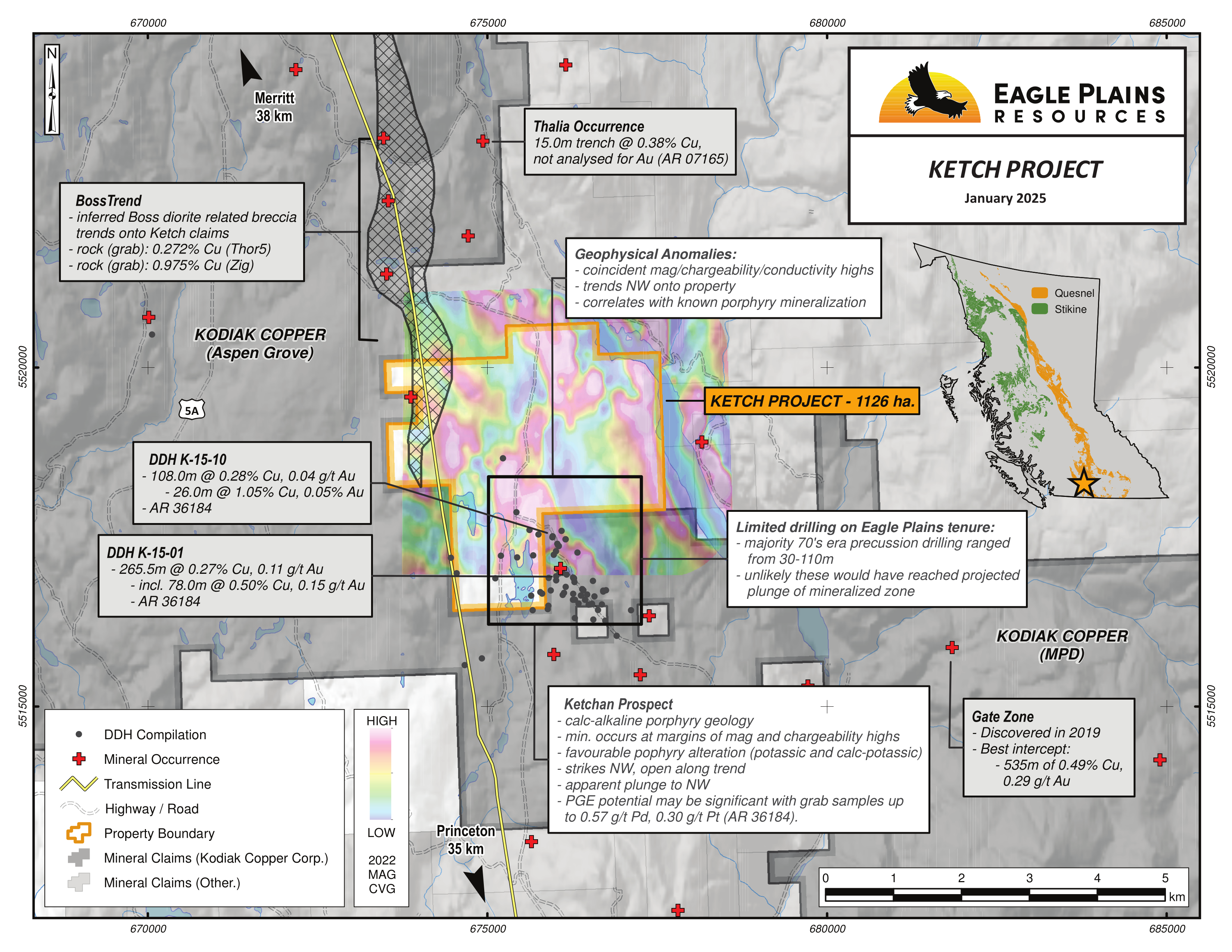
The 1126 ha Ketch property is located in South-Central British Columbia, 37 km north-northwest of Princeton and 40 km southeast of Merrit. The claims are highly prospective for porphyry related mineralization. The property is positioned 3 km east of highway 5A and is accessible via a well-maintained network of roads and is bisected by a high-powered transmission line.
The project was acquired through staking and is owned 100% by Eagle Plains Resources with no underlying royalties or encumbrances.
-
- British Columbia
-
- Available for option: Yes
-
- Copper,
- Gold,
- Silver,
- Platinum
Project Highlights
- Road accessible with nearby rail, highway, hydro and ore processing facilities
- Located in the Quesnel Terrane, a world-class porphyry district
- Calc-alkalic porphyry geology with Copper, Gold, Silver, PGE’s
- Untested high-priority geophysical targets associated with favourable geology
- Significant Cu-Au porphyry drill intercepts within ~150m of the SE property boundary
Details
The 1126 ha Ketch property is located in South-Central British Columbia, 37 km north-northwest of Princeton and 40 km southeast of Merrit. The claims are highly prospective for porphyry related mineralization. The property is positioned 3 km east of highway 5A and is accessible via a well-maintained network of roads and is bisected by a high-powered transmission line.
The project was acquired through staking and is owned 100% by Eagle Plains Resources with no underlying royalties or encumbrances.
Project Highlights
- Road accessible with nearby rail, highway, hydro and ore processing facilities
- Located in the Quesnel Terrane, a world-class porphyry district
- Calc-alkalic porphyry geology with Copper, Gold, Silver, PGE’s
- Untested high-priority geophysical targets associated with favourable geology
- Significant Cu-Au porphyry drill intercepts within ~150m of the SE property boundary
Geology
The Ketch Property overlies geology of the southern Quesnel Terrane, a complex package of Late Triassic to Early Jurassic plutonic, volcanic and sedimentary rocks deposited in a volcanic island arc. The Quesnel Terrane hosts a number of known mineral deposits (mainly porphyry Cu-Au±Ag±Mo) and within South-Central BC the terrane hosts five operating mines: Gibraltar, Mount Polley, New Afton, Highland Valley Copper and Copper Mountain. Locally, bedrock consists primarily of Upper Triassic Nicola Group extrusive volcanic rocks and coeval subvolcanic rocks which are intruded by Early Jurassic diorites and gabbro. Within the Ketch project area, the Nicola Group rocks can be subdivided into three facies (western, central, eastern) constrained by two North-South trending regional faults related to the Nicola volcanism. The property overlies the central facies of the Nicola group, bound by the Allison Fault, separating the western and central facies 4 km west of the tenure. The Kentucky-Alleyne fault runs east of the tenure, intersecting the property in the northeast corner. The central Volcanic facies is intruded by coeval and co-magmatic diorite to monzodiorite intrusive bodies known to host alkalic porphyry copper-gold mineralization.
On a property scale, the east side is dominated by tuffs and volcanic-derived sediments of the Missezula and Iron Mountain Formations. The southern and central core of the project is mapped as dominantly extrusive volcanic and volcanic-derived sediments of the Shrimpton and Iron Mountain Formations. Geophysical and mapping interpretation by past operators indicated that geology of these zones may include significantly more Late Triassic diorites (Ketchan Trend) that form a NW-SE trend onto the southern extent of the property. The late Triassic intrusions in the Ketchan Trend display intense k-feldspar alteration and are further altered by monzonite breccias of hydrothermal origin. The north and northwestern portion of the property is dominated by volcanic derived sedimentary rocks of the Shrimpton Formation and Late Triassic monzodiorites of the Copper Mountain Suite.
The Ketchan prospect is a significant zone of alkalic porphyry copper-gold-silver mineralization. The Ketchan diorite, which is recognizable in regional magnetic geophysical surveys as a 1x15 km long magnetic high, trends SE-NW directly onto the Southern portion of the Ketch claims. Mineralization is hosted by a multiphase intrusive sequence (pyroxene-biotite diorite, a hornblende monzonite/monzodiorite and diorite to monzodiorite breccias) that have undergone widespread brecciation and extensive alteration. Interpretation of historic drill results indicate that mineralization is hosted dominantly within an early potassic (magnetite+epidote+K-feldspar) and later sodic-calcic (albite+epidote+amphibole) alteration facies and grade may be best in zones of overprinting alteration facies. Mineralization consists mainly of chalcopyrite and lesser bornite. Multiple drillholes on claims adjacent to the Ketch Property have tested the Ketchan trend. DDH K-15-01 (150m east of current tenure) returned 265.5m @ 0.27% Cu and 0.11 g/t Au; DDH K-15-10 (130m east of current tenure) returned 108.0m @ 0.28% Cu and 0.04 g/t Au. Historical drill holes on the Ketch tenure targeted the Ketchan trend but are interpreted to have shut down shallow of the target stratigraphy and did not adequately test the mineralization potential of the porphyry stock. Recent analysis of magnetite-rich diorites indicates potential for significant PGE enrichment in zones that may not be prospective for Cu-Au mineralization. PGE sampling and interpretation to date is limited, follow-up is recommended.
The Boss trend includes a sequence of Mineral Occurrences (including the Log 1, Zig, Zig 1-3, Thor 5 and Boss) that form a north-south trend that underlies the northern portion of the Ketch claims. The zone is recognizable in geophysical surveys as an extensive (2x3 km) magnetic high interpreted to represent the Boss Diorite which is underlain by dioritic intrusive breccia complex. Outcrop mapping along the Boss Diorite complex shows lithologies ranging from massive, strongly magnetic diorite, intrusive breccias and well fragmented monomictic diorite breccias. Epidote alteration and carbonate veinlets are common with mineralization consisting of chalcopyrite, chalcocite and malachite. Mineralization has been traced out in historical trenches and blast pits over a length of 350m. Percussion drillholes completed by Cominco in 1979 confirmed the position of altered diorite, returning grades of 0.141% Cu over 32 m.
The Thalia Trend is spatially separated from the Boss Diorite complex by a sequence of tuff breccias. Unlike the Boss diorite, the Thalia diorite is represented in geophysical surveys as a series of magnetic lows due to the high hematite content and relative lack of magnetite. The Thalia diorite is adjacent to the north trending Kentucky-Alleyne Fault system which trends south to Missezula lake, bisecting the eastern portion of the property. Modern mapping of historical trenches indicates two phases of intrusion including a crowded plagioclase-phyric diorites and a pervasively hematized monzodiorite. Contacts between the intrusive types appear to grade into each other and magnetite may increase locally along trend to the south. Where the Thalia diorite is inferred to underly the tenure it is overlain by Quaternary basalt flows. Mineralization within the Thalia diorites is associated with widespread carbonate, sericite, epidote and hematite alteration and consists mains of disseminated and vein hosted chalcocite and copper carbonate. Historical trench samples returned results of 0.38% Cu over 15 meters.
Exploration History
Exploration in the Ketchan Lake Area began in the 1960’s with Plateau Metals and Adera Mining completing a magnetometer and IP surveys with accompanying diamond drilling and trenching programs. Holes targeted the Ketchan Trend southwest of the current Ketch property boundaries.
Between 1973-1980 Bethlehem Copper was actively exploring the Log Group mineral claims. Exploration included large scale geological mapping and geochemical sampling programs that were followed up with a series of diamond and percussion drill programs. Limited information of these drill programs is publicly available.
In 1991-1992 Cominco Ltd completed 23 percussion drillholes along the Ketch Trend. These holes produced the first economically significant results from the trend. While 3 of the holes drilled by Cominco overlap the current Ketchan mineral claims (PDH B-04 to -06) they did not return significant results. Future operators interpreted these holes to have been stopped short of geophysical anomalies that define the Ketchan diorite complex.
Additional diamond drilling was completed in 2005-2007 by Copper Belt Resources and Midland Resources on the Ketchan Lake Property, completing 17 holes at the Ketchan Lake trend. The holes successfully delineated the trend, with hole K-05-04 (560m west of current tenure boundary) returning 100.6m @ 0.38% Cu and 0.10 g/t Au.
In 2013-2014 West Cirque Resources completed detailed mapping and sampling of outcrops and historical trenches in the Ketchan Lake area. 12 representative trench samples returned results from 0.08-1.07% Cu and up to 0.458 g/t Au over a strike length of 300m. Mapping and prospecting also highlighted the potential for PGE mineralization in magnetite-bearing diorites. Geologists indicate that PGE mineralization may be unrelated to Cu-Au mineralization and should be considered a secondary target.
Further Diamond drilling by Kaizen Resources was completed around the Ketchan Area in 2015-2016. Drillhole K-15-01 (170m west of current tenure boundary) and K-15-10 (130m west of current tenure boundary).
In 2018 Golden Lake Exploration Inc completed an airborne EM survey (Expert Geophysics MobileMT) to further define lithologies, structure and alteration zones within the Copperview North Property. The southwestern edge of the survey overlaps the current Ketch Project and provides valuable geophysical data (magnetics and conductivity) further defining the Ketchan, Boss and Thalia trends within the claim boundaries.
Eagle Plains Exploration
In 2024 Eagle Plains completed prospecting and property reconnaissance to assess outcrop potential and property access.
Future Work
Advancing the Ketch property and vectoring to mineralization may be achieved through a combination of field mapping, rock sampling, soil sampling, IP and Magnetic geophysical surveying. Specific recommendations are as follows:
- Compile all historical data available for the project to identify prospecting/mapping coverage, make interpretations based on available data and highlight any gaps
- Complete notice of work (NOW) application for a 5-year Area Based Exploration Permit (MYAB)
- Complete strategic IP surveys to further delineate targets related to the Ketch, Boss and Thalia Trends
- Complete diamond drill campaign assessing geochemical and geophysical targets
Eagle Plains - A Project Generator
Eagle Plains Resources is a project generator with mineral exploration properties of merit that meet qualifying transaction requirements. We facilitate the listing process for capital pool companies and initial public offerings while providing technical expertise for exploration programs. Companies interested in co-operatively exploring any of these projects please contact: Charles Downie at ccd@eagleplains.com or Mike Labach at mgl@eagleplains.com or call 1 866 Hunt Ore (486 8673).
The Ketch property is currently available for option.
Updated January 17, 2025