Lost Horse Project
The 3,759 ha Lost Horse property is located in South-Central British Columbia, 99 km north of Kamloops and 27 km west-southwest of Clearwater. The project, owned 100% by Eagle Plains Resources, was acquired through staking and third-party purchase agreements.
The claims are highly prospective for porphyry intrusion and epithermal type precious- and base-metal mineralization. The property is road accessible via a well-maintained network of forest service roads.
-
- British Columbia
-
- Available for option: Yes
-
- Gold,
- Silver,
- Zinc,
- Copper
Project Highlights
- Potential for multiple deposit types including: alkalic porphyry copper-gold, epithermal gold and skarn
- Untested coincident geochemical/geophysical anomalies associated with favourable geology
- Road accessible with nearby rail, highway, hydro and ore processing facilities
- Active 5-year MYAB exploration permit
Summary
Geology
The property is located on the Nehalliston Plateau and is underlain by arc volcanic, plutonic, and sedimentary rocks belonging to the Quesnel Terrane. Locally, the Quesnel Terrane is composed primarily of Upper Triassic Nicola Group rocks which are intruded by Early Jurassic diorites. The property overlies significant regional faults
There are many significant mineral occurrences in the areas immediately surrounding the tenure boundaries displaying skarn-, epithermal- and porphyry-type mineralization. The number of mineral occurrences proximal to the Lost Horse Project, ranging from underexplored to advanced stage, highlights the highly prospective nature for porphyry related mineralization.
Exploration History
Industry exploration has a long history in the region with the Lakeview skarn prospect discovered in 1930. Systematic exploration in the region continued in 1966 to present, focussing on Co-Mo-Au porphyry exploration and has included significant mapping, prospecting, geophysical and drilling campaigns.
Eagle Plains Exploration
During August 2022 soil sampling, stream silt sampling, rock sampling, and geologic mapping field program were completed on the property. The results returned from this program indicate that the Lost Horse property has significant mineral potential.
Based on historical geophysical results, geochemical trends, and visual indicators, mineralized features on the property have a well-defined, northwest trend. Field observations suggest that mineralization on the property is likely related to low-sulphidation epithermal veining which could also indicate a buried, mineralized porphyry in the region.
Eagle Plains - A Project Generator
Eagle Plains Resources is a project generator with mineral exploration properties of merit that meet qualifying transaction requirements. We facilitate the listing process for capital pool companies and initial public offerings while providing technical expertise for exploration programs. Companies interested in co-operatively exploring any of these projects please contact: Charles Downie at ccd@eagleplains.com or Mike Labach at mgl@eagleplains.com or call 1 866 Hunt Ore (486 8673).
The Lost Horse property is currently available for option.
Updated August 27, 2024
Details
The 3,759 ha Lost Horse property is located in South-Central British Columbia, 99 km north of Kamloops and 27 km west-southwest of Clearwater. The project, owned 100% by Eagle Plains Resources, is comprised of the main Lost Horse claim with 4 non contiguous mineral claims and were acquired through staking and third-party purchase agreements.
The claims are highly prospective for porphyry intrusion and epithermal type precious- and base-metal mineralization. The property is road accessible via a well-maintained network of forest service roads.
The project has an active Multi-Year Area Based (MYAB) exploration permit valid until Sept 2028. Permitted activities include diamond drilling, mechanical trenching, road building and IP geophysics
Project Highlights
- Potential for multiple deposit types including: alkalic porphyry copper-gold, epithermal gold and skarn
- Untested coincident geochemical/geophysical anomalies associated with favourable geology
- Road accessible with nearby rail, highway, hydro and ore processing facilities
- Active 5-year MYAB exploration permit
Geology
The property is located on the Nehalliston Plateau and is underlain by arc volcanic, plutonic, and sedimentary rocks belonging to the Quesnel Terrane. Locally, the Quesnel Terrane is composed primarily of Upper Triassic Nicola Group rocks which are intruded by Early Jurassic diorites. Nicola Group rocks on the property can be subdivided into three units: basaltic volcanics, felsic volcanics, and intercalated volcanic and sedimentary rocks.
The eastern portion of the main Lost Horse tenure is cut by the north-northwest trending Rock Island Lake Fault System. Just west of the property the northwest-trending Monticola Lake – Gammarus Lake Fault System juxtaposes Nicola volcanic rocks to the east with sedimentary rocks of the Ripple Lake belt to the west. A major fold, the NW-striking Nehalliston Syncline, has been interpreted to cross the centre of the property.
Mineralization
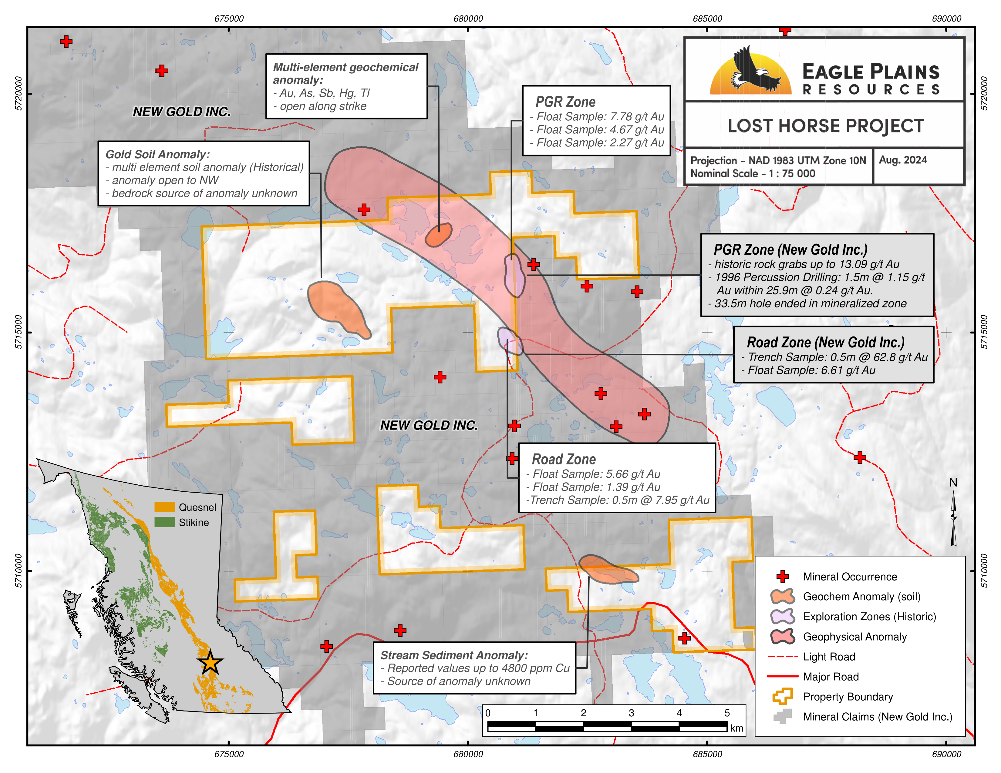
A single documented mineral occurrence occurs on the tenure package, underlying the Lost Horse Southeast claims, however there are many significant occurrences in the areas immediately surrounding the tenure boundaries. The Latremouille Showing (MinFile 092P 166) is described as an epidote altered hornblende diorite cut by a narrow, mineralized (pyrite-chalcopyrite) quartz vein. Historical analytical results returned 2.2 g/t Ag and 892.0 ppb Au but the showing has not undergone significant exploration work or interpretation and remains underexplored.
Significant showings in the surrounding area include the HC Gold, HC Silver, and PGR occurrences. These showings are described as healed fault-breccia zones within sedimentary and volcanic units of the Nicola Group. Hydrothermal activity, presumably associated with alkalic porphyries, is evident with prominent quartz-carbonate veins which host gold, silver, lead, zinc, and copper. Comparable mineralization has been observed on the property.
Near Deer Lake, several occurrences, namely the Silver, Wandering Dog, and Pycu showings, are located along the margins of dioritic intrusions as skarns. Mineralization is hosted within carbonate units proximal to these intrusions as heavy disseminations to massive magnetite, pyrite, and pyrrhotite with anomalous copper, zinc, and gold values.
Two occurrences, the RO and FL showings, are located north of the property and Friendly Lake. These showings are both hosted in brecciated volcanic rock and host disseminated pyrite, chalcopyrite, galena, sphalerite, molybdenite, and arsenopyrite. The anomalous copper, molybdenum, lead, and zinc is considered to be indicative of a possible Cu-Mo-Au porphyry.
The number of mineral occurrences proximal to the Lost Horse Project, ranging from underexplored to advanced stage, highlights the highly prospective nature for porphyry related mineralization.
Exploration History
Industry exploration has a long history in the region with the Lakeview skarn prospect discovered in 1930.
From 1966 to 1974, several companies, including Anaconda American Brass Limited, United Copper, and Imperial Oil, conducted extensive exploration programs in the region. Exploration focused on the discovery of Cu-Mo porphyry deposits by extensive soil sampling, geophysical surveying, and geological mapping. Although several soil and geophysical anomalies were delineated, no major discoveries were made.
From 1981 to 1986, exploration work by SMD Mining Co. Ltd., Lornex Mining Corporation Ltd., Selco, and BP Resources Canada targeted alkalic Cu-Au porphyry deposits. Programs mainly consisted of extensive soil sampling, stream silt sampling, and IP geophysical surveying which led to the demarcation of numerous anomalous zones. Percussion drilling conducted by Lornex in 1983 returned some anomalous copper and zinc values, but overall non-economic results.
From 1988 through to 2009, exploration activity focus shifted to auriferous veins and alteration zones. Lancer Resources Inc. and Rat Resources Ltd. conducted several soil sampling, trenching, and drilling programs in 1988/89. One hole drilled in 1988 returned 4.3 g/t Au over 3.10m from quartz-iron carbonate veins in pyritic siltstone. From 1992 to 1995, R.C. Wells, P.S. Watt, and Electrum Resource Corp. conducted a series of small rock sampling, soil sampling, and stream-silt sampling programs with rock samples returning up to 7.78 g/t Au at Zone A and 5.66 g/t Au at the Road Zone. In 1995 and 1997, Cambridge Minerals Ltd. completed a trenching and drilling program which returned 62.8 g/t Au + 183.0 g/t Ag, and 1.15 g/t Au over 1.5m, respectively. From 1998 to 2009, Christopher James Gold Corp., Electrum Resources Corp., and Lithic Resources Ltd. completed a number of smaller rock sampling, stream-silt sampling, airborne, trenching, and geophysical surveying programs.
Eagle Plains Exploration
During August 2022 soil sampling, stream silt sampling, rock sampling, and geologic mapping field program were completed on the property. Geological mapping and rock sampling work was conducted with the primary goal of defining structural controls, alteration zoning, and lithological implications for gold-silver mineralization. Foot traverses were undertaken throughout the central and eastern portions of the property. The program was successful in confirming gold-silver-zinc mineralization on the property. The work program confirmed and characterized mineralizing features at historically described showings. Overall, gold-silver-zinc mineralization on the property is primarily related to extensional, brecciated, sulphide-bearing quartz veins hosted in altered andesite host rock. The results returned from this program indicate that the Lost Horse property has significant mineral potential.
TerraLogic Exploration recently completed the 2024 field program at the Lost Horse. Fieldwork included mapping and prospecting, till sampling and tight spaced soil sampling in areas of interest identified with past work. Results from the 2024 program are pending.
Based on historical geophysical results, geochemical trends, and visual indicators, mineralized features on the property have a well-defined, northwest trend. Field observations suggest that mineralization on the property is likely related to low-sulphidation epithermal veining which could also indicate a buried, mineralized porphyry in the region.
Future Work
Advancing the Lost Horse property and vectoring to mineralization may be achieved through a combination of field mapping, rock sampling, soil sampling, and IP geophysical surveying. Specific recommendations are as follows:
- Extension of the central soil grid to the north, east of Lost Horse Lake. A broad geochemical anomaly exists at the northern end of the 2022 soil grid, further soil sampling to the north is recommended to define the extent of the anomaly
- Further soil sampling in the western portion of the property should be completed around a gold-in-soil anomaly to determine the extents of that anomaly
- Follow-up field mapping and rock sampling should be completed over soil geochemical anomalies identified in the 2022 program, particularly on the under-explored western portion of the property
- IP geophysical surveying in the central and eastern portions of the property around the Road and A Zones. IP surveying may prove useful to identify silicified, resistive zones or chargeable, disseminated sulphide-bearing zones. Historic geophysical surveys conducted near the eastern portion of the property indicate a chargeability high that trends towards the Lost Horse tenure, IP geophysical surveying may indicate whether this chargeability feature is present as a buried target in the eastern portion of the property
- Mapping and prospecting of claims that have seen limited historical exploration work
Eagle Plains - A Project Generator
Eagle Plains Resources is a project generator with mineral exploration properties of merit that meet qualifying transaction requirements. We facilitate the listing process for capital pool companies and initial public offerings while providing technical expertise for exploration programs. Companies interested in co-operatively exploring any of these projects please contact: Charles Downie at ccd@eagleplains.com or Mike Labach at mgl@eagleplains.com or call 1 866 Hunt Ore (486 8673).
The Lost Horse property is currently available for option.
Updated August 27, 2024

Eagle Plains Provides Update on Lost Horse Copper-Gold Project / Announces Termination of Agreement With 1416753 B.C. Ltd
Photos