Rusty Springs Project
The 627 ha Rusty Springs Property is located 8 km south of the Arctic Circle and 29 km east of the Alaska border. Access is by wheel/ski-equipped aircraft or by winter road.
The great extent of mineralized and altered rocks, stratabound nature and common significant thicknesses, high grades and potential for supergene enrichment make Rusty Springs an attractive target for large-tonnage base- and precious-metal deposits.
-
- Yukon Territory
-
- Available for option: Yes
-
- Silver,
- Zinc,
- Lead
Project Highlights
- Multiple Bonanza-grade Ag occurrences property-wide
- High-priority drill targets
- Favourable geology for hosting a significant sulphide replacement zone
- Encouraging exploration to date with comprehensive database
- Infrastructure includes airstrip and bulldozer on-site
Summary
The 627 ha Rusty Springs Property is located 8 km south of the Arctic Circle and 29 km east of the Alaska border. Access is by wheel/ski-equipped aircraft or by winter road.
The great extent of mineralized and altered rocks, stratabound nature and common significant thicknesses, high grades and potential for supergene enrichment make Rusty Springs an attractive target for large-tonnage base- and precious-metal deposits.
Project Highlights
- Multiple Bonanza-grade Ag occurrences property-wide
- High-priority drill targets
- Favourable geology for hosting a significant sulphide replacement zone
- Encouraging exploration to date with comprehensive database
- Infrastructure includes airstrip and bulldozer on-site
Geology
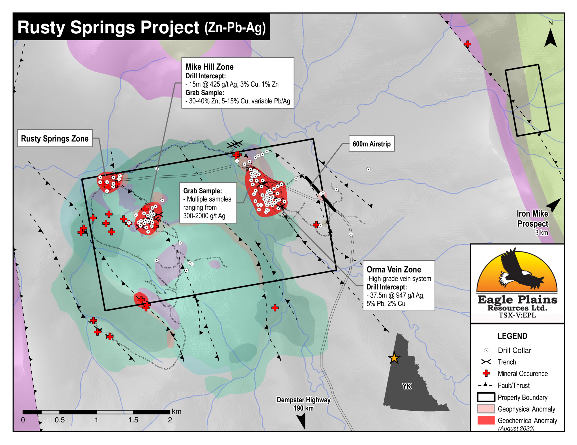
Exploration has targeted either stratabound or discordant styles of mineralization, both of which are found throughout the property. They occur almost exclusively in the upper Ogilvie Formation and in the vicinity of the Mike Hill and Orma Vein zones. Their spatial association, similar geochemistry and association with similar brecciated and dolomitized zones suggest a genetic link. Although stratabound mineralization may have greater thickness, much greater continuity, and can be much more readily explored, high grade epithermal Pb-Ag veins are also an attractive target.
History
Discovered and staked in 1975, Rusty Springs has had nearly $5m in exploration, including 123 drill holes, targeting high-grade Ag, Pb, Cu, and Zn mineralization. Prospecting, mapping, geochemistry and geophysics were used to select drill locations. Previous operators commonly averaged 300 – 2000 g/t Ag in grab samples and up to 30-40% Zn, and 5-15% Cu in samples of float material.
Recovery of drill core was poor and penetration to the target horizon was thwarted by a cap layer of “chert”, however, when drilling was successful results have been significant:
| Sample Type | Interval | Results |
|---|---|---|
| Drill 1977 | 37.5 m | 947 g/t Ag, 4.72% Pb, 2.36% Cu, poor recoveries overall |
| Drill 1995 (EPL) | 15.3 m | 425 g/t Ag, 3% Cu and 1.3% Zn |
Eagle Plains Exploration
Nine significant exploration programs have been conducted since acquisition in 1992 consisting of regional reconnaissance, trenching, diamond-drilling, reverse circulation drilling, geochemical and geophysical surveys, mapping and prospecting. Other work includes airstrip and road construction. Recent exploration focussed on placing the mineralization in a modern, regional context, resulted in:
- The base-metal and Ag showings at Orma and Mike Hill are structurally controlled, epigenetic, hydrothermal metal concentrations.
- There is appreciable hydrothermal alteration in the four showings
Future Work
Put the main mineral showings in the context of fold and thrust belts which may provide vectors to a prospect of economic significance. This should be done concurrently with development of both a sulphide and an oxide Zn target.
Incorporate the large amount of past work into a single database. Integration of the drill and surface data should help to predict where structures intersect in the subsurface.
Reinterpretation and integration of the geophysical data
Eagle Plains - A Project Generator
Eagle Plains Resources is a project generator with several mineral exploration properties of merit that meet qualifying transaction requirements. We facilitate the listing process for capital pool companies and initial public offerings while providing technical expertise for exploration programs. Companies interested in co-operatively exploring any of our projects please contact: Chuck Downie at ccd@eagleplains.com or Mike Labach at mgl@eagleplains.com or call 1 866 Hunt Ore (486 8673).
Details
The 627 ha Rusty Springs Property is located 8 km south of the Arctic Circle and 29 km east of the Alaska border. Access to the property is via wheel or ski-equipped aircraft or by winter road. An all-weather, 600m airstrip was completed in 1996 and brushed in 2011 with a D7 Cat. A 193 km winter road accesses the property from the Dempster Highway. The project is 100% owned by Eagle Plains with a 2% NSR held by Eagle Royalties containing a 1% buy-back clause.
The property has seen considerable exploration over a 40 year period, and remains highly prospective for a large-tonnage precious-metal enriched base-metal deposit. The great extent of mineralized and altered rocks, together with their stratabound nature, common significant thicknesses, local high grades, and potential for supergene enrichment make Rusty Springs an attractive exploration target.
Associated with the Rusty Springs project is the Iron Mike property located 3 km to the NE. The mineralization of interest at the Iron Mike is a ridge of massive bedded magnetite measuring 366 m along strike and 46 m thick. Several samples taken along strike have returned values of between 55% and 58% iron.
Project Highlights
- Multiple Bonanza-grade Ag occurrences property-wide
- High-priority drill targets
- Favourable geology for hosting a significant sulphide replacement zone
- Encouraging exploration to date with comprehensive database
- Infrastructure includes airstrip and bulldozer on-site
Geology
Exploration models utilized at Rusty Springs have tended to exclusively target either stratabound or discordant styles of mineralization (e.g, Mississippi Valley-type or Irish Plains-type for the former, hydrothermal veins for the latter).There is evidence for both styles on the property, and they appear to be genetically related. Both styles of mineralization are found almost exclusively in the upper Ogilvie Formation and in the vicinity of the Mike and Orma discoveries. Their spatial association, similar geochemical signatures and association with similar brecciated and dolomitized zones suggests a genetic link.
History
Rusty Springs was first staked in 1975 after investigation of the deep red-orange springs and seeps in the valley of Carrol Creek led to the discovery of nearby Ag, Pb, Zn, and Cu mineralization.
Since the discovery, the property has had nearly $5m exploration, including ten separate drill campaigns in two major phases (1975-83 and 1994-96) totalling over 10,000 m of drilling in 123 holes.
Exploration has mainly targeted high-grade Ag, Pb, Cu, and Zn mineralization within brecciated and quartz and carbonate cemented and veined dolomite, and has been based on several genetic models including: Mississippi Valley-type (“MVT”); Irish-type (carbonate hosted exhalative); epithermal-type (veins and/or hydrothermal replacement along a karsted surface, with supergene enrichment); and manto-chimney-type (high temperature, carbonate-hosted massive sulphides).
Drill holes were located by prospecting, mapping, geochemistry and geophysics. Drilling was plagued by poor recoveries in the strongly oxidized and leached mineralized intervals, loss of water pressure in blocky brecciated zones with abundant open space and by resistant siliceous 'chert' horizons that cap the mineralized stratigraphy. Trenching also met with varying success because of deep permafrost and overburden.
Rio Alto (1976 – 80) and Kenton Natural Resources (1982 – 86) conducted exploration at Rusty Springs. Samples collected from several localities on the property returned values of:
| Sample Type | Results |
|---|---|
| Float | 30-40% Zn, 5-15% Cu, and variable Pb/Ag |
| Grab | commonly averaged 300 – 2000 g/t Ag |
Although recovery of drill core was poor and penetration to the target horizon thwarted by a cap layer of “chert”, when drilling was successful results have been significant:
| Sample Type | Interval | Results |
|---|---|---|
| Drill 1977 | 37.5m | 947 g/t Ag, 4.72% Pb, 2.36% Cu, poor recoveries overall |
| Drill 1995 (EPL) | 15.3m | 425 g/t Ag, 3% Cu and 1.3% Zn |
The claims were gradually allowed to lapse, and in 1992 Eagle Plains restaked the core area of the property.
Eagle Plains Exploration
Eagle Plains has conducted 9 significant exploration programs on the property from 1994 through 1999, then 2001, 2006 and 2011. Exploration work consisted of regional reconnaissance, trenching, diamond-drilling, reverse circulation drilling, geochemical and geophysical surveys, mapping and prospecting.
Other work on the project has included airstrip and exploration trail construction. A clean-up effort of refuse and fuel barrels from previous programs resulted in the Yukon government awarding Eagle Plains with the 2005 Robert E. Leckie Award for Outstanding Exploration Reclamation Practices.
In 1997, Robert Hodder, Ph.D., P.Eng., visited the property and examined existing drill core, outcrop, trenches and technical data. He concluded that "The limonitic interval at Rusty Springs is a resource of hundreds of millions of tons, but of very subeconomic amounts of base- or precious-metals ... the limonitic interval and it's enclosed quartz veins and lamellae are however vital symptoms that ore forming processes existed for major deposits of Ag-Pb-Zn and that deposits of this type cluster in districts of economic potential". He also recommended focusing on locating sulphides below the present and paleo water table. In 2006, Hodder revisited the property with a subsequent data review suggesting that although the current geologic dataset is accurate, it could be reinterpreted in a modern geologic context. Specifically, the property geology / mineralization be put in a fold and thrust context and the close to 40 showings may be utilized to vector towards larger sulphide or non-sulphide Pb-Zn deposits.
Eagle Plains Exploration – 2011 Field Program
The main objective of this program was to revisit and define geologic features to determine how they may be used to direct future exploration efforts. The program consisted of a regional geophysical survey and an attempt to place the mineralization in a modern, regional context. Conclusions and results include:
- The base metal and Ag showings at Orma and Mike Hill are structurally controlled, epigenetic, hydrothermal metal concentrations.
- There is appreciable hydrothermal alteration in the four showings
- The exploration should target Pb and Ag in epigenetic quartz veins as well as stratabound mineralization
- The geophysical survey did not delineate any obvious buried intrusives or discordant magnetic anomalies on the property.
Future Work
- Integrate the main mineral showings into the current context of fold and thrust belts to provide vectors to locate a prospect of economic significance. This should be done concurrently with development of both a sulphide and an oxide Zn target.
- Incorporate the large amount of past work into a single geologic / geochemical database. Integration of the drill and surface data should help to predict where structures intersect in the subsurface.
- 3rd party interpretation of the geophysical data involving geologic integration
Eagle Plains - A Project Generator
Eagle Plains Resources is a project generator with several mineral exploration properties of merit that meet qualifying transaction requirements. We facilitate the listing process for capital pool companies and initial public offerings while providing technical expertise for exploration programs. Companies interested in co-operatively exploring any of our projects please contact: Chuck Downie at ccd@eagleplains.com or Mike Labach at mgl@eagleplains.com or call 1 866 Hunt Ore (486 8673).
Updated May 1, 2024
Photos