Schott's Lake Project
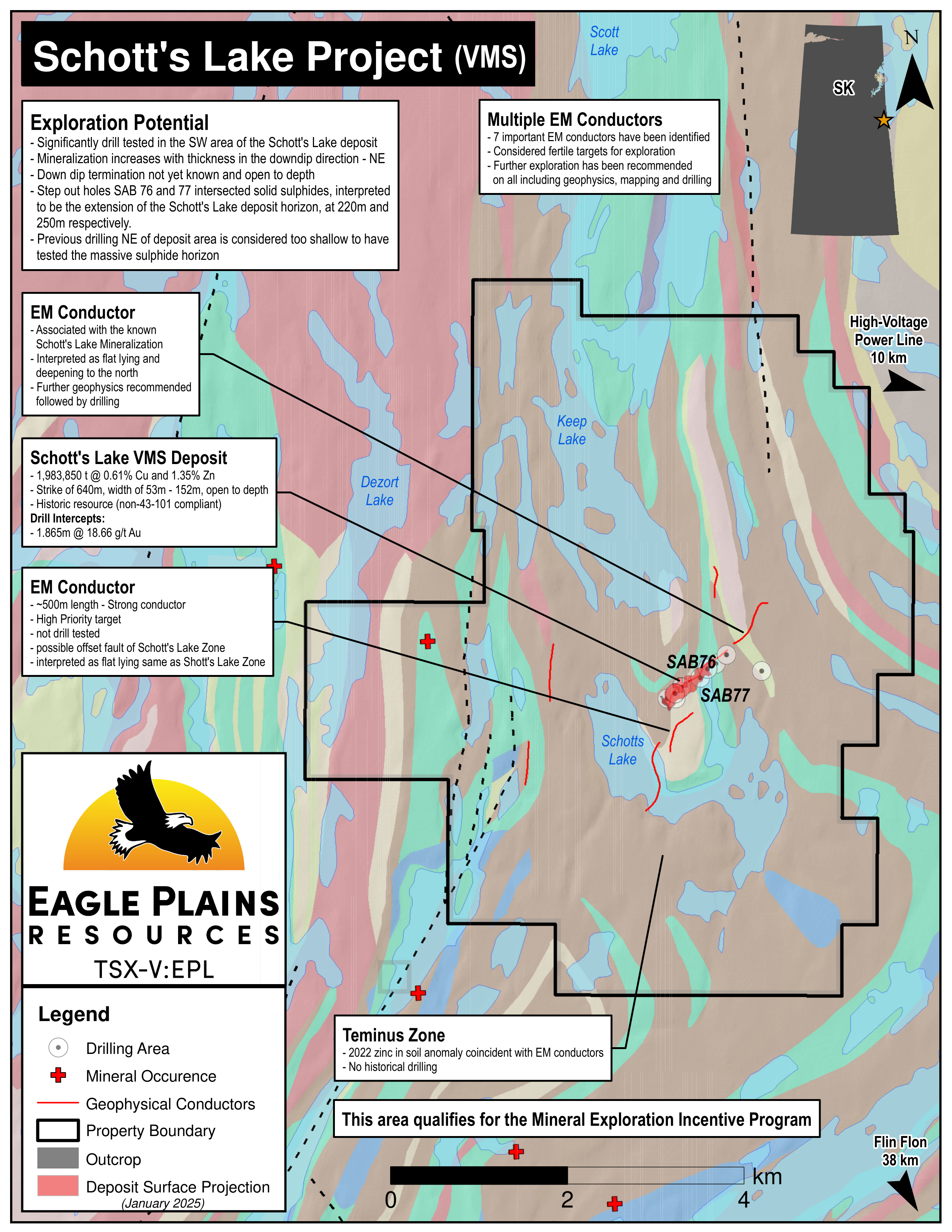
The 3225 ha Schotts Lake Property hosts the Schotts Lake Zone, a volcanogenic massive sulphide (“VMS”) polymetallic deposit with a historical resource (non-43-101 compliant) of 1,983,850 tonnes grading 0.61% Cu and 1.35% Zn. The property is located 40km NW of Flin Flon Manitoba and 8.5km west of a power transmission line. Access is by winter road or float plane. The project is 100% owned by Eagle Plains with a 2% NSR held by Eagle Royalties containing a 1% buy-back clause.
-
- Saskatchewan
-
- Available for option: Yes
-
- Copper,
- Zinc
Project Highlights
- Host to the Schotts Lake Zone - a VMS deposit with a historic resource and open to depth*
- Excellent geology highly prospective for VMS mineralization
- Prospective untested conductive trend to the west of the Schotts Lake Zone
- Numerous untested geophysical conductors
- Excellent Infrastructure including drill roads and nearby rail, highway, airport, hydro
*Eagle Plains’ management considers these estimates to be historical in nature and cautions that a Qualified Person has not done sufficient work to classify the historical estimates as current mineral resources or mineral reserves in accordance with National Instrument 43-101. These estimates do not comply with current definitions prescribed by National Instrument 43-101 or the Canadian Institute of Mining, and are disclosed only as indications of the presence of mineralization and are considered to be a guide for additional work. The historical models and data sets used to prepare these historical estimates are not available to Eagle Plains, nor are any more recent resource estimates or drill information on the Property..
Summary
The 3225 ha Schotts Lake Property hosts the Schotts Lake Zone, a volcanogenic massive sulphide (“VMS”) polymetallic deposit with a historical resource (non-43-101 compliant) of 1,983,850 tonnes grading 0.61% Cu and 1.35% Zn. The property is located 40km NW of Flin Flon Manitoba and 8.5km west of a power transmission line. Access is by winter road or float plane. The project is 100% owned by Eagle Plains with a 2% NSR held by Eagle Royalties containing a 1% buy-back clause. Project Highlights
- Host to the Schotts Lake Zone - a VMS deposit with a historic resource and open to depth*
- Excellent geology highly prospective for VMS mineralization
- Prospective untested conductive trend to the west of the Schotts Lake Zone
- Numerous untested geophysical conductors
- Excellent Infrastructure including drill roads and nearby rail, highway, airport, hydro
*Eagle Plains’ management considers these estimates to be historical in nature and cautions that a Qualified Person has not done sufficient work to classify the historical estimates as current mineral resources or mineral reserves in accordance with National Instrument 43-101. These estimates do not comply with current definitions prescribed by National Instrument 43-101 or the Canadian Institute of Mining, and are disclosed only as indications of the presence of mineralization and are considered to be a guide for additional work. The historical models and data sets used to prepare these historical estimates are not available to Eagle Plains, nor are any more recent resource estimates or drill information on the Property..
Geology
The area of the Schotts Lake property is host within the Reindeer Zone of the Paleoproterozoic Trans-Hudson Orogen. The Reindeer Zone lies between the northwestern edge of the Churchill-Superior Boundary Zone and the southeastern margin of the Wathaman-Chipewyan Batholith. The Reindeer Zone consists of a collage up to 400 km wide of arc and ocean floor volcanic rocks, plutons, and younger molasse and turbiditic sedimentary rocks. The Schotts Lake property is situated within the Attitti Block, which is characterized in the Wildnest Lake area by upper amphibolite facies supracrustal rocks and granitoids. The Attitti Block is interpreted to be a high-grade metamorphic equivalent of the Flin Flon Domain that extends to the south and east. The boundary between the Attitti Block and the Kisseynew Domain to the east is interpreted as a facies change from dominantly volcanic to dominantly sedimentary rocks.
History
In 1953 mineralization at Schotts Lake was discovered by J.A.Syme and in 1954 a small drill program into the gossan discovered the deposit. Between then and 2014 Schotts Lake has been explored approx. 9 companies including HudBay Exploration and Development Co. It’s been the focus of 15 exploration programs including 7 geophysical surveys, both airborne and ground based, and 6 diamond drill programs for approx. 77 holes over 11262m.
Mineralized Zone
The Schotts Lake mineralized zone, as indicated by drilling, extends from the outcrop area on the west side of the narrow north arm of Schotts Lake to a point beneath the eastern shoreline of this arm. The zone strikes 325°, dips 18° to 20°NE and has a down dip length of approximately 640 m. Width varies from 53 m to 152 m and an average thickness of 20.4 m. Mineralization is probably continuous, thickness increases with depth, and the lower limit has not been ascertained. Drilling has indicated bands of disseminated sulphides with local concentrations of ore grade material. These bands vary from a few inches to over 15.2 m. The deepest drilling, 266 m, has revealed two distinct copper-bearing zones which generally increase in copper content with depth and decrease in zinc.
Future Work
The Schotts Lake deposit is interpreted to sit on the eastern limb of a synformal anticline. The western limb has not been explored adequately. There are a string of VTEM and SpectrEM anomalies on the western limb that plunge in the same direction as the VTEM and SpectrEM anomalies from the eastern limb (Schotts Lake deposit). DPEM coverage is recommended to adequately cover the western limb, over the lake and to the north near the deposit.
The 2015 geophysical survey identified several highly prospective conductors, namely conductor #4 located south of the Schott’s Lake deposit. Geophysical interpretation suggests this could be a faulted offset of the Schott’s Lake deposit and has not been drill tested.
Other prospective areas include to the north and north east of the deposit area where drilling has not tested the projected depth of dip of the Schott’s Lake deposit.
Eagle Plains - A Project Generator
Eagle Plains Resources is a project generator with several mineral exploration properties of merit that meet qualifying transaction requirements. We facilitate the listing process for capital pool companies and initial public offerings while providing technical expertise for exploration programs. Companies interested in co-operatively exploring any of our projects please contact: Chuck Downie at ccd@eagleplains.com or Mike Labach at mgl@eagleplains.com or call 1 866 Hunt Ore (486 8673).
Details
The 3225 ha Schotts Lake Property hosts the Schotts Lake Zone, a volcanogenic massive sulphide (“VMS”) polymetallic deposit with a historical resource (non-43-101 compliant) of 1,983,850 tonnes grading 0.61% Cu and 1.35% Zn. The property is located 40km NW of Flin Flon Manitoba and 8.5km west of a power transmission line. Access is by winter road or float plane. The project is 100% owned by Eagle Plains with a 2% NSR held by Eagle Royalties containing a 1% buy-back clause. Project Highlights
- Host to the Schotts Lake Zone - a VMS deposit with a historic resource and open to depth*
- Excellent geology highly prospective for VMS mineralization
- Prospective untested conductive trend to the west of the Schotts Lake Zone
- Numerous untested geophysical conductors
- Excellent Infrastructure including drill roads and nearby rail, highway, airport, hydro
*Eagle Plains’ management considers these estimates to be historical in nature and cautions that a Qualified Person has not done sufficient work to classify the historical estimates as current mineral resources or mineral reserves in accordance with National Instrument 43-101. These estimates do not comply with current definitions prescribed by National Instrument 43-101 or the Canadian Institute of Mining, and are disclosed only as indications of the presence of mineralization and are considered to be a guide for additional work. The historical models and data sets used to prepare these historical estimates are not available to Eagle Plains, nor are any more recent resource estimates or drill information on the Property..
Geology
The bedrock underlying the Schotts Lake showing area consists essentially of Kisseynew-type gneisses of sedimentary origin, particularly hornblende, biotite, biotite-garnet, and calc-silicate gneisses. The only surface indications of mineralization are several outcrops of rusty, quartz-biotite gneiss and biotite-garnet gneiss near the east shore of the broad peninsula separating the two northern arms of Schotts Lake. The gossan consists of a red, calcrete-like soil that occurs within a creek bed over a strike length of 100 m (328.1 ft) across a width of 25 m (82.0 ft). A single outcrop exposes a series of quartz-rich rocks with minor simmimanite, muscovite, and pyrite. Over the zone, trenching through the yellow-orange soil exposes disrupted quartz-rich rocks that contain up to 7% pyrite.
The overturned massive sulphide mineralization that comprises the zone lies on the abnormal limb of a Z-fold located on the eastern limb of the major synform. The axial plane of this synform dips moderately to the east and plunges moderately to the NE. The deposit is thought to be a typical exhalitive massive sulphide zone of mineralization that formed proximal to volcanic and volcaniclastic rocks. The host rocks are mapped as a series of volcanic and volcaniclastic rocks. An interpreted alteration zone (poikiloblastic hornblende-plagioclase-quartz gneiss and quartz-feldspar-biotite-sillimanite gneiss) overlies the massive sulphide deposit. The alteration zone is overlain by a small calcsilicate unit. The footwall alteration zone mineralogy is variable and this zone has a discordant relationship with the other rock units. The deposit contains some distal magnetite-bearing sulphide facies and oxide-silicate facies iron formation (up to 10% pyrite plus rare chalcopyrite). Re-mapping described the host rocks as being derived from felsic volcanic rocks and associated sedimentary rocks with subsequent interpretation of the host rocks representing interbedded arenaceous to argillaceous sediments and felsic to intermediate volcanic rocks.
History
In 1953 J.A. Syme staked the Schott’s Lake area and in 1954 completed drill 7 holes over 49.5 m into the gossans and discovered the deposit. Later that year the property was optioned to Hudbay, and electromagnetic geophysics located several anomalies that were tested by 32 drill holes over 3116.3 m intersecting sections of mineralization.
In June 1955, Kay Lake Mines followed up surface work with 31 drill holes over 3763 m revealing sulphide mineralization at depth.
In 1960, Schott Lake Mines Ltd. calculated a reserve estimate.
In 1966, International Mineral Corp. completed two drill holes encountering disseminated to massive mineralization.
In 1969, Scope Resources and Stall Lake Mines completed 26 drill holes over 3314 m on the deposit and increased the reserve estimate of the deposit.
In 1991, OMT Oils completed ground VLF-EM and magnetic surveys covering the deposit and the following year Sarabat Gold completed ground EM and magnetic surveys on the showing. In 1993, these parties drilled 2 holes to test the deposit at depth, one encountered the down-dip extension of the zone and the other a pyrite-graphite horizon.
In 1998, Aur Resources completed a magnetic survey over the deposit. Partnering with Thundermin Resources, they completed geological mapping, prospecting, and rock sampling and re-logged the drill hole that encountered the down-dip extension. This work covered the deposit and adjacent areas to the west and north.
The next significant work was conducted by Hudbay in 2015, an airborne geophysical survey to expose any previously undetected conductors in the vicinity of the Schotts Lake zone. This program identified 7 conductors of interest and made specific work recommendations for each:
Geophysical Conductors - HudBay 2015 Deep Penetrating Electromagnetic Survey
- Conductor #2 - Located west of Schott’s Lake and trending SSW to NNE, this 1.7km long conductor is interpreted to be shallow in the south (~100m) and deepening to the north (>500m). Recommendations are to conduct further geophysics and drill test the southern portion
- Conductor #3 - Located east of the Schott’s Lake VMS deposit and bisecting Schott’s Lake, this SSW to NNE trending EM conductor is 3km long, 2-300m in depth and extremely conductive. Further geophysics are recommended
- Conductor #4 - This 500m long SSW to NNE trending conductor is located directly south of the Schott’s Lake VMS deposit area and in the center of the broad peninsula between the two northern arms of Schott’s Lake. It is interpreted as being a potential faulted off portion of the Schott’s Lake VMS deposit. It is a flat lying strong conductor, has not been drill tested and represents high priority drill target
- Conductor #5 - Recommendations for this N-S south trending 900m long strong conductor is for further geophysics
- Conductor #6 - This conductor is associated with the known mineralization of the Schott’s lake VMS deposit and bisects it on a SW to NE trend. It is interpreted to indicate that the mineralization is laying horizontal and deepening to the north. This conductor has been extensively drill tested to the south but in the north it has been tested with only two holes, 34 and 35. Hole 34, drilled vertically, hit near solid sulphide (with little chalcopyrite but some sphalerite intersections) at around 220m and hole 35 hit near solid sulphide at 250m with chalcopyrite around the intersection
- Conductor #7 - Located NE of the Schott’s Lake VMS Deposit, it appears to be associated with conductor #6 that bisects the deposit but is interpreted to be separate as it starts as a moderate signal in the south and increases in strength to the north. Geologically they could have some relation but geophysically they appear unique. Recommendations are for further geophysics to refine drill targets
- Conductor #8 - This 600m long N-S trending conductor is located approx. 450m east of the SE shore of Keep Lake. It is extremely conductive and unique for the area due to its broad shoulder response. Drill Hole 22 tested the area but only to a depth of 53m, this anomaly is interpreted to be significantly deeper, therefore, it remains untested. Further geophysics and ground investigation is recommended.
Mineralized Zone
The Schotts Lake deposit is interpreted to sit on the eastern limb of a synformal anticline. The western limb has not been explored adequately. There are a string of VTEM and SpectrEM on the western limb that plunge in the same direction as the VTEM and SpectrEM from the eastern limb (Schotts Lake deposit) and are extremely conductive.
The Schotts Lake mineralized zone, as indicated by drilling, extends from the outcrop area on the west side of the narrow north arm of Schotts Lake to a point beneath the eastern shoreline of this arm. The zone strikes 325°, dips 18° to 20°NE and has a down dip length of approximately 640 m. Width varies from 53 m to 152 m and an average thickness of 20.4 m. Mineralization is probably continuous, thickness increases with depth, and the lower limit has not been ascertained. Drilling has indicated bands of disseminated sulphides with local concentrations of ore grade material. These bands vary from a few inches to over 15.2 m. The deepest drilling, 266 m, has revealed two distinct copper-bearing zones which generally increase in copper content with depth and decrease in zinc.
The following table outlines significant historical drill intercepts:
Table 1- Significant Drill Intercepts-Schotts Lake Project*
| Hole | Width (m) | From (m) | To (m) | Cu (%) | Zn (%) |
|---|---|---|---|---|---|
| 1 | 16.7 | unk | unk | 1.1 | 1.83 |
| 4 | 0.76 | unk | unk | 4.3 | 3.3 |
| 13 | 5.8 | 30.4 | 36.2 | 2.5 | 0.17 |
| 35 | 1.7 | 256.8 | 258.5 | 2.07 | 0.01 |
| 65 | 15.8 | 82.3 | 98.1 | 0.38 | 1.84 |
| 66 | 7.6 | 71.6 | 79.2 | 0.96 | 5.48 |
| 67 | 3.0 | 49.1 | 52.1 | 1.71 | 3.48 |
| 68 | 17.9 | 133.8 | 151.7 | 0.85 | 1.53 |
| 69 | 18.3 | 128.2 | 146.5 | 0.53 | 1.09 |
| 70 | 22.7 | 149.7 | 172.4 | 0.54 | 1.96 |
| 75 | 27.4 | 183.5 | 210.9 | 0.35 | 2.25 |
Future Work
The Schotts Lake deposit is interpreted to sit on the eastern limb of a synformal anticline. The western limb has not been explored adequately. There are a string of VTEM and SpectrEM anomalies on the western limb that plunge in the same direction as the VTEM and SpectrEM anomalies from the eastern limb (Schotts Lake deposit). DPEM coverage is recommended to adequately cover the western limb, over the lake and to the north near the deposit.
The 2015 geophysical survey identified several highly prospective conductors, namely conductor #4 located south of the Schott’s Lake deposit. Geophysical interpretation suggests this could be a faulted offset of the Schott’s Lake deposit and has not been drill tested.
Other prospective areas include to the north and north east of the deposit area where drilling has not tested the projected depth of dip of the Schott’s Lake deposit.
Eagle Plains - A Project Generator
Eagle Plains Resources is a project generator with several mineral exploration properties of merit that meet qualifying transaction requirements. We facilitate the listing process for capital pool companies and initial public offerings while providing technical expertise for exploration programs. Companies interested in co-operatively exploring any of our projects please contact: Chuck Downie at ccd@eagleplains.com or Mike Labach at mgl@eagleplains.com or call 1 866 Hunt Ore (486 8673).
Updated January 10, 2025